near to Colne, Lancashire, England
Coverage
We have
248 images
in grid square SD8839
Maps
TIP: Click the map for more Large scale mapping
Tip: Click the map to open the coverage map
A sample of 12 photos from 248
for SD8839
- View this square in the Browser >>>

|
Terrace Houses, Walton Street, Colne, Lancashire
The three terraces shown on this picture, from left to right, are Walton Street west and east side, and Basil Street west side. The outlines of other buildings, now demolished, can be traced from stones that remain.
|

|
Colne Town Centre
Since 1972 this building has been used by the Providence Independent Methodists as their place of worship. It was originally built in 1869 for Nicholas England, a local cotton manufacturer. In 1907 it was converted and became a Carnegie... (more)
|

|
Knotts Lane
Knotts Lane in Colne.
|

|
End of the line
Beyond the buffers were freight yards and an engine shed, so this solitary buffer stop is a world away from the heyday of railways
|

|
"TaxAssist Accountants" 1, Primet Hill, Colne, Lancashire BB8 9NF
by Robert Wade
|

|
Path from Green Road to Hagg Street, Colne |

|
Elizabeth II Postboxes on Albert Road, Colne
by JThomas
Outside the former Post Office.
Postbox No. BB8 359.
Postbox No. BB8 360.
See SD8839 : Former Post Office on Albert Road, Colne for context.
|

|
Admiral Lord Rodney, Mill Green, Colne |

|
Colne station plaques
The two blue plaques record that Colne was connected by rail to Skipton from 1848 to 1970 and to Burnley from 1849 to the present day.
|
|
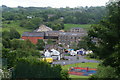
Colne South Valley
by Bill Boaden
In the centre is the Admiral Lord Rodney. I planned my walk around this pub, knowing it was supposed to be a good supplier of local ales, only to find that it was shut.
|

|
Colne from the railway viaduct
A residential area of Colne on the south side of Colne Water as viewed from the railway viaduct.
|

|
Methodist Church Building Colne
Situated at the junction of Smith St with Albert Rd Colne, the building has a date stone 1906 and was a Methodist Church although I do not know what it was called. It may have been used by Sutherland Terrace Wesleyan Methodists although... (more)
|
Explore more images in this square: | View Filtering options | View all 248 images page by page >>> |
|