near to Hobson, County Durham, England
Coverage
We have
24 images
in grid square NZ1655
Maps
TIP: Click the map for more Large scale mapping
Tip: Click the map to open the coverage map
Sample images
Breakdown list
images taken from NZ1655 [1]
A sample of 12 photos from 24
for NZ1655
- View this square in the Browser >>>

|
Path along Mountsett Fell
Looking SW towards Dipton. The path runs along the route of an 18th century colliery waggonway. The Fell was once lowland heath, but is now much overgrown with scrub. The flowers are Rosebay Willowherb.
|

|
Trees beside Lintzhall Dene
Lintzhall Dene is the shallow groove beyond the foreground crop. Chopwell Woods are seen in the middle distance beyond the Derwent Valley.
|

|
Bowes Railway Path
by Oliver Dixon
The Bowes Railway was one of the oldest railways in the world, sections of which were constructed by George Stephenson in 1826, and extended from Pontop to the Tyne at Jarrow. In 1842 it was bought and restored by John Bowes and Partners... (more)
|

|
Track to Toft Gate Farm
by JThomas
|

|
Toft Gate Farm, near Pickering Nook
by Alan Fearon
|

|
Terraced Houses Upper Lintz
by Les Hull
|
|
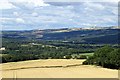
View up the valley from Mountsett
A view looking west up the Derwent Valley from the path along Mountsett Fell. This is on the top of the southern slope of the valley, hence the good views. Hamsterley Hall can be seen on the extreme left. The farm in the woods to the right... (more)
|

|
Toft Gate Farm
by JThomas
|

|
Looking down the road towards Pickering Nook
This road was the former main road, until a bypass was built to the right to cut off the steep hill climb.
|

|
Foot- and cycle-path alongside Syke Road
by Oliver Dixon
This path forms part of Regional Route 11 of the National Cycle Network, which for the most part follows the trackbed of the old Bowes Railway.
Over this section it appears to have diverged from the line of the railway and runs behind... (more)
|

|
Farmland, Toft Gate
by JThomas
|

|
Lane north from Upper Lintz
This country lane runs from Upper Lintz farm to Lintz estate in Burnopfield. This was originally the site of Lntz Colliery.
|
Explore more images in this square: | View Filtering options | View all 24 images page by page >>> |
|