near to Tarbet Hole [water Feature], Fife, Great Britain
Coverage
We have
270 images
in grid square NT6599
Maps
TIP: Click the map for more Large scale mapping
Tip: Click the map to open the coverage map
A sample of 12 photos from 270
for NT6599
- View this square in the Browser >>>
|
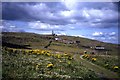
Isle Of May
The Isle of May is in the background the shot was taken from the summit of North Berwick Law
|
|
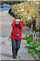
Tern Attack
by Anne Burgess
The path between the landing stage and the main part of the island crosses the Arctic Tern nesting area. The terns are aggressive and noisy and attack visitors as they walk up or down the path. Here a visitor shields her head as two angry... (more)
|
|
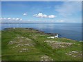
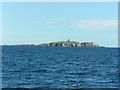
North end of the island
by James Allan
Looking from the top of the Main Light towards the North Horn on the Isle of May. The distant coast is Fife, near Crail, about five miles away.
|
|
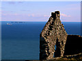
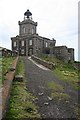
May Isle first lighthouse
Built in 1636 this lighthouse burned coal to help the sailing ships avoid the rocks. It was taller when it was built but they reduced the height when a more modern light was built.
|
|
Isle of May - track towards lighthouse
by Colin Park
|
|
Approaching the Isle of May |
|
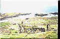
Saint Adrian's Priory, Isle of May
by ronnie leask
St.Adrian was killed on the May by marauding Vikings in 875 and in the 12th century King David founded a priory dedicated to him. Archaeological excavations have taken place over the past few years and human remains unearthed, thought to be... (more)
|
|
Coastline, Isle of May
The eastern coastline of the Isle of May.
|
|
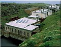
Fluke Street
by James Allan
This was the name given to this row of lighthouse buildings by Royal Navy personnel stationed on the Isle of May during WW2. The nearest building is the compressor house, which once supplied air (stored in the red cylindrical tanks) to... (more)
|
|
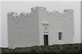
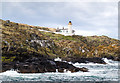
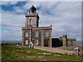
The Main Light
by Anne Burgess
This is the principal light on the island, built on the highest point, and the only one still in operation, though since 1989 it has been remotely operated.
|
|
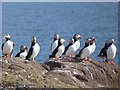
A circus of puffins (set of 3 images)
by Oliver Dixon
The puffins have arrived in their thousands at the end of March this year, unusually early.
|
|
Lighthouse on the Isle of May |
Explore more images in this square: | View Filtering options | View all 270 images page by page >>> |
|