near to Port Ramsay, Lismore, Argyll And Bute, Scotland
Coverage
We have
44 images
in grid square NM8944
Maps
TIP: Click the map for more Large scale mapping
Tip: Click the map to open the coverage map
Sample images
Breakdown list
images taken from NM8944 [2]
A sample of 12 photos from 44
for NM8944
- View this square in the Browser >>>
|
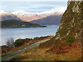
Lynn of Lorne
by Chris Morgan
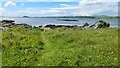
Looking over Appin Rocks
|
|
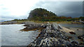
Lynn of Lorn from near the Appin Rocks
Looking across to the northern tip of Lismore with Beinn na Cille directly behind.
|
|
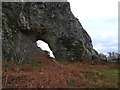
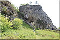
Clach Tholl
by Gordon Brown
- means 'Holed Rock' at the south end of the Port Appin promontory.
|
|
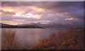
Appin rocks with Lismore in the background
I'm fairly sure that the mountains in the distance are on Mull.
|
|
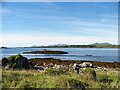
Rubha Clach Thoull
by Peter Bond
From right out at the edge of the tide.
|
|
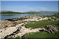
Rubha Clach Tholl
On the southeast shoreline of the Lynn of Lorn to the southwest of Port Appin, with the northeast end of the island of Lismore on the left.
|
|
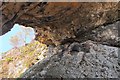
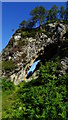
Underneath the arch, Clach Toll
by Jim Barton
The rock arch from below; the photo's orientation is correct - check the tree!
|
|
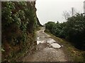
Gravel road (gated) near Clach Tholl
by Steven Brown
|
|
Clach Thoull near Airds Bay, taken from Lismore side
for more details see NM8741 : Eilean Dubh taken from the South (Lynn of Lorn)or NM8944 : Clach Thoull near Airds Bay
|
|
Clach Thoull Footpath
The footpath from Port Appin to Clach Thoull (sometimes Tholl, as on OS map) - the stone with the hole. Lismore Island, Loch Linnhe and the hills of Kingairloch in the distance.
|
|
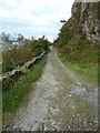
Track to Port Appin
by Peter Bond
Part of the circular path that takes in Clach Thoull.
|
|
At Port Appin - Clach Tholl Natural Arch
by Colin Park
|
Explore more images in this square: | View Filtering options | View all 44 images page by page >>> |
|