St. Louis River AOC
Leah Medley
(medley.leah@epa.gov)
312-886-1307
Overview
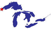
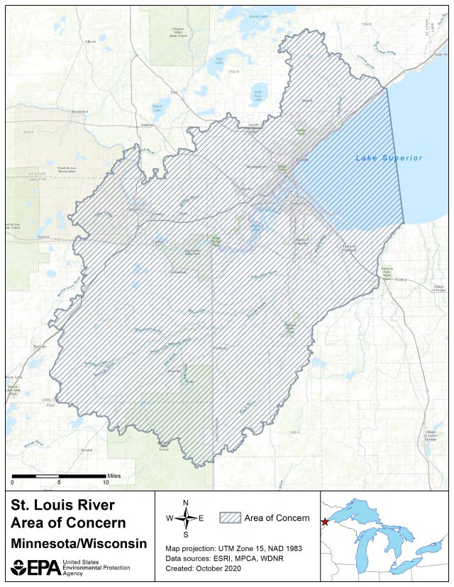
The St. Louis River AOC is one of the 31 U.S.-based Areas of Concern across the Great Lakes created under the 1987 Great Lakes Water Quality Agreement. Draining 3,634 square miles of watershed and encompassing a 1,020 square-mile area, the St. Louis River is the second largest U.S.-based AOC. It crosses state boundaries, including both the states of Minnesota and Wisconsin. As the largest tributary to Lake Superior, the St. Louis River is vital to the regional economy and encompasses the Port of Duluth-Superior, an essential port for Great Lakes shipping. The AOC also includes Superfund sites, large boat slips, important fish spawning habitat and Spirit Lake - a site with spiritual significance to the Fond du Lac Tribe.
Historical industrial use of the river, before the onset of modern pollution laws, resulted in sediments contaminated with mercury, dioxins, polychlorinated biphenyls, polycyclic aromatic hydrocarbons and other toxins.
Pollutants in the AOC are also due to historical discharges from wastewater and landfills and other discharges within the AOC.
Beneficial Use Impairments
An interim success of remediation and restoration work is removing Beneficial Use Impairments (BUIs). BUIs are designations created by the International Joint Commission, representing different types of significant environmental degradation. As cleanup work is completed, and monitoring demonstrates sufficient environmental health improvements, BUIs can gradually be removed. The list below shows which BUIs have been removed, and which remain. Once all BUIs are removed, the process of delisting the AOC can begin.
- Restrictions on Fish and Wildlife Consumption
- Degraded Fish and Wildlife Populations - Removed January 2021
- St. Louis River Fish Tumors BUI Removals (pdf) - Removed February 2019
- Degradation of Benthosenthos
- Restrictions on Dredging Activities
- St. Louis River Eutrophication or Undesirable Algae BUI Removal package (pdf) - Removed April 2020
- Beach Closings
- St. Louis River Aesthetics BUI Removals (pdf) Removed August 2014
- Loss of Fish and Wildlife Habitat
General information about BUIs: Beneficial Use Impairments for the Great Lakes AOCs
Remediation and Restoration Work
EPA has continually worked with federal, state and local partners to execute remediation and restoration work in the area with the goal of removing the AOC designation and revitalizing the surrounding communities.
To delist the St. Louis River AOC, 80 management actions must be completed. Forty-four of these management actions are sediment remediation and habitat restoration construction projects and half of those have been completed.
Sediment remediation projects will remove contaminants such as PAHs and heavy metals from the environment. Habitat restoration is beneficial for improving plant and animal populations. Actions for completing restoration invasive species control, fish passage projects, wetland restoration, and increasing habitat connectivity.
To delist this AOC, a goal of restoring 50 percent (1,700 acres) of degraded aquatic habitat has been set. Not only will these projects enhance environmental productivity, but they will also add significant socioeconomic value to the surrounding communities.
-
Completed Project Highlights

Remediation and restoration project accomplishments.
-
Table of Projects
Remediation and restoration table.
-
Restoration Documents

Remediation and restoration documents.
Active Projects
Sediment Remediation Project: C Reiss Superior Dock Terminal Environmental Dredging

The C Reiss Superior Dock Terminal is a 53-acre dock and slip in Port of Superior, Wisconsin. In Partnership with the C Reiss Coal Company, LLC, EPA plans to dredge portions of the slip to remove contaminated sediment to address beneficial use impairments. Sediment quality has been impacted by the historical, industrial use of the slip which included bulk material handling operations, including coal and petroleum products. Remedial design is complete, and implementation is anticipated to begin Summer 2024.
Elevated levels of polycyclic aromatic hydrocarbons (PAHs) within the sediments at C Reiss Superior Dock Terminal have impacted benthic invertebrate populations living within it, and this in turn affects other animal populations that feed on those invertebrates. Based on the levels of contaminants present in available samples, dredging followed by confined disposal of any dredged sediments from this site has been identified as the most suitable remediation action to address the contaminants in the slip. Prior to removal of contaminated sediment, dock wall rehabilitation must occur first for safe removal contaminated sediment.
The St. Louis River Area of Concern (AOC) identifies sediment remediation in the C Reiss Superior Dock Terminal as management action 5.29 for removing Beneficial Use Impairments (BUIs) at this AOC. The completion of this project will contribute to the removal of the Restrictions on Dredging Activities and Degradation of Benthos BUIs, and will ultimately help lead to the delisting of the St. Louis River as an AOC.
Sediment Remediation Project: Munger Landing
Munger Landing, also known as Clyde Avenue Boat Launch, is located on a small channel separated from the main shipping channel by a long, narrow island on the St. Louis River. Located in western Duluth in the St. Louis River AOC, Munger Landing features one of three boat launches in Duluth and a fishing pier, making it a popular recreational location for fishing, birding, and boating activities. However, due to historical industrial activity, contaminated sediment containing lead, nickel, zinc, polychlorinated biphenyls (PCBs), and dioxins/furans has accumulated at the landing, within the channel, and in a nearby wetland, contributing to public and wildlife health concerns.
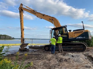
EPA, Minnesota Pollution Control Agency (MPCA), and Wisconsin DNR, in partnership with industry, began a 2-year project to remediate contaminated sediment at the Munger Landing site. The remediation project dredged approximately 100,000 cubic yards of sediment and soil from the landing, channel, and wetland. Dredged areas will be covered with a clean layer of sand. The project will remove invasive species, install native plants, and restore underwater areas for fish spawning. The project will also replace the boat ramp and create a sandy paddle sport launch area north of the fishing pier. The Munger Landing sediment removal project began in summer 2022 and is anticipated to be completed in the 2023/2024 winter season. The second and final season of dredging began June 24, 2023 at Munger Landing. During this time, Munger Landing will be closed to the public.
An additional cleanup took place in Snively Creek upstream of the Munger Landing project area in summer 2023 to control sources of contamination. Contaminated soil and sediment will be removed from the upper reach of the creek. Contamination assessments on the middle and lower reach areas of Snively Creek are ongoing.
Munger Landing Sediment Project Factsheet (pdf)

After completing the remediation, the Munger Landing site will provide a cleaner and safer area for recreation and for fish and wildlife. There are additional plans by the City of Duluth to add trails and increase water access for boaters and paddlers. This project will contribute to the removal of the following BUIs:
- Restrictions on Fish and Wildlife Consumption
- Loss of Fish and Wildlife Habitat
- Beach Closings
- Degradation of Benthos
- Restrictions on Dredging Activities
Sediment Remediation Project: Thomson Reservoir

Thomson Reservoir is located where St. Louis and Midway rivers meet just north of Thomson, Minnesota within the St. Louis River AOC. The 330-acre Thomson Reservoir was constructed in 1908 to be used in hydroelectric power generation. The St. Louis River flows through the Thomson Reservoir, and due to historic industrial and municipal activity, contaminated sediments have accumulated within the reservoir and need to be addressed.
A Focused Feasibility Study of sediment quality in the reservoir discovered elevated concentrations of dioxins/ furans in the sediments. Dioxins/furans are likely to affect benthic invertebrates that live in/on the sediment. As birds and fish consume the invertebrates, the contaminants move up the food chain. Studies have confirmed that fish within the reservoir contain varying levels of the bioaccumulative contaminant, dioxin/furans.
GLRI funding was used in the project's design phase by the U.S. Army Corps of Engineers (USACE) in partnership with the MPCA. With the design phase complete, EPA and MPCA are partnering under the Great Lakes Legacy Act to implement the project. In-water work will begin in 2024 and will wake place over two seasons. The remediation project will address contaminated sediment by placing a carbon amendment in the reservoir where significant levels of contamination are present. A carbon amendment reduces the contaminant uptake by plants and animals by reducing the availability of toxins in the sediment to the macroinvertebrates. Macroinvertebrates are an essential food source for fish. Therefore, by reducing the levels of contaminants to macroinvertebrates, levels of contaminants higher up in the food chain will also be reduced.
After sediment remediation, Thomson Reservoir will be a cleaner, safer environment for aquatic organisms and humans. This project will contribute to the removal of the following BUIs:
• Restrictions on Dredging Activities
• Degradation of Benthos
• Restrictions on Fish and Wildlife Consumption
Sediment Remediation Project: Legacy Act Spirit Lake Cleanup
Spirit Lake is a large open area in the St. Louis River located near the former U.S. Steel site. When the Duluth Works steel plant was operational, several pollutants including PAHs and heavy metals such as lead, copper, and zinc, were released into Spirit Lake. Under the Great Lakes Legacy Act, EPA and U S Steel (USS) worked with project partners to develop a comprehensive plan to remediate contaminated sediment from Spirit Lake.
The project involved dredging contaminated sediment, in-place capping, thin-layer capping and placement of material on two on-site confined disposal facilities that were constructed as part of the project. A total of 460,000 cubic yards of impacted sediment was removed and a protective cap was placed over 119 acres. Dredging will also improve the aquatic ecosystem by creating new public waters, including a 42-acre shallow, sheltered bay, restoring open water aquatic habitat for fish spawning and restoring wetlands. The cleanup plan goals are to lower concentrations of PAHs and heavy metals below certain levels in the river.
The cleanup operations began in October 2020. Dredging and capping of contaminated sediment was completed in 2022. Habitat restoration plantings took place through fall of 2023 and occurred in upland and in-water portions of the site. Construction of the recreational features, including the pedestrian trail, were completed in fall of 2023 and are expected to be open to the public in spring 2024. In addition to the pedestrian trail, installation of interpretive signage, establishment of a publicly accessible waterfront with fishing, and canoe-kayak launches provides significant recreational improvements. In total over 138 acres of habitat was created or enhanced.
Read information and look at pictures from the Spirit Lake Great Lakes Legacy Act Cleanup.
Sediment Remediation Project: Ponds Behind Erie Pier
Ponds Behind Erie Pier are two backwater ponds surrounded by shallow marsh wetlands located behind Duluth’s Erie Pier. In 2015, this area, as well as a portion of a connecting creek, was investigated for cleanup where heavy metals, mercury, PAHs, PCBs and dioxins/furans were determined to be contaminants of concern in the sediment. These contaminants are the legacy of historical heavy industry activity before environmental regulations. To address the contaminated sediment, the EPA and Minnesota Pollution Control Agency have signed a $16 million Great Lakes Legacy Act Project Agreement to remediate contaminated sediment in this area. As a cost sharing partnership, MPCA will contribute up to $5.6 million.
Ponds Behind Erie Pier Trail Closure (pdf)
- Restrictions on Fish Consumption
- Loss of Fish and Wildlife Habitat
- Degradation of Benthos
- Restrictions on Dredging Activities
Remediation consisted of dredging the two ponds and the connecting Shopper’s Creek, temporarily storing and dewatering the sediments on site, disposing of the dewatered sediments at an off-site landfill and placing approximately 6-inches of clean cover material over the two ponds. The contaminant levels in fish will be reduced, making them safer for consumption. After the cleanup native vegetation will be restored and the clean cover material will create habitat for bottom-dwelling bugs and fish.

Sediment Remediation Project: Scanlon Reservoir
Scanlon Reservoir is located on the St. Louis River downstream of Cloquet and east of Scanlon, Minnesota within the St. Louis River AOC. The reservoir is approximately 40 acres and is immediately upriver of the Scanlon Dam. Scanlon Reservoir was constructed in 1923 and the water has been used for hydroelectric generation since its completion. St. Louis River flows through the Scanlon Reservoir and due to historic industrial and municipal activity, contaminated sediments have accumulated within the reservoir and need to be addressed.
In 2014, MPCA conducted a targeted investigation of sediment quality in the reservoir and discovered elevated concentrations of dioxins/ furans in the bottom sediments. Dioxins/furans are likely to affect benthic invertebrates that live in/on the sediment. As invertebrates are consumed by birds and fish, the contaminants move up the food chain. Studies have confirmed that fish within the reservoir contain varying levels of the bioaccumulative contaminant, dioxin/furans.

In 2022, EPA and MPCA completed the remediation of 55,000 cubic yards of contaminated sediment in the Scanlon Reservior. Project partners applied a thin layer of carbon pellets to 13.5 acres of aquatic habitat in the reservoir. A carbon layer reduces the contaminant uptake by plants and animals by reducing the availability of toxins in the surface sediment to the macroinvertebrates. Macroinvertebrates are an important food source for fish. Therefore, by reducing the levels of contaminants to macroinvertebrates, the levels of contaminants up the food chain should also be reduced. Open water areas with contamination received an application of a carbon sand mixture. Areas of shallow water with wetlands had only carbon applied to protect sensitive plants. Additionally, native plants were restored in upland construction areas.
After sediment remediation, Scanlon Reservoir will be a cleaner, safer environment for both aquatic organisms and humans. This project will contribute to the removal of the following BUIs:
- Restrictions on Dredging Activities
- Degradation of Benthos
- Restrictions on Fish and Wildlife Consumption
Partners
- NOAA
- U.S. Army Corps of Engineers
- U.S. Fish and Wildlife Service
- U.S. Geological Survey
The following links exit the site


