JOURNAL OF GEOPHYSICAL RESEARCH, VOL. 112, F02029, doi:10.1029/2006JF000598, 2007
Analysis of the 2001 lava flow eruption of Mt. Etna from
three-dimensional mapping
M. Coltelli,1 C. Proietti,1,2 S. Branca,1 M. Marsella,2 D. Andronico,1 and L. Lodato1
Received 14 June 2006; revised 17 November 2006; accepted 21 December 2006; published 1 June 2007.
[1] The 2001 Etna eruption was characterized by a complex temporal evolution with the
opening of seven eruptive fissures, each feeding different lava flows. This work
describes a method adopted to obtain the three-dimensional geometry of the whole lava
flow field and for the reconstruction, based on topographic data, of the temporal evolution
of the largest lava flow emitted from a vent located at 2100 m a.s.l. Preeruption and
posteruption Digital Elevation Models (DEM) were extracted from vector contour maps.
Comparison of the two DEMs and analysis of posteruption orthophotos allowed us to
estimate flow area, thickness, and bulk volume. Additionally, the two-dimensional
temporal evolution of the 2100 flow was precisely reconstructed by means of maps
compiled during the eruption. These data, together with estimates of flow thickness,
allowed us to evaluate emitted lava volumes and in turn the average volumetric flow rates
The analysis performed in this paper provided, a total lava bulk volume of 40.1 � 106 m3
for the whole lava flow field, most of which emitted from the 2100 vent (21.4 � 106 m3).
The derived effusion rate trend shows an initial period of waxing flow followed by a
longer period of waning flow. This is in agreement not only with the few available effusion
rate measurements performed during the eruption, but also with the theoretical model
of Wadge (1981) for the temporal variation in discharge during the tapping of a
pressurized source.
Citation: Coltelli, M., C. Proietti, S. Branca, M. Marsella, D. Andronico, and L. Lodato (2007), Analysis of the 2001 lava flow
eruption of Mt. Etna from three-dimensional mapping, J. Geophys. Res., 112, F02029, doi:10.1029/2006JF000598.
1. Introduction
[2] On active volcanoes each new effusive eruption alters
the local topography and builds new morphological features. This requires to modify existing maps for keeping
topographic maps up-to-date and collecting accurate quantitative data such as flow area, volume and effusion rate.
The availability of detailed maps contributes to monitoring
efforts and it is valuable to understand and model the
eruptive processes. Currently, several numerical lava flow
models are available [Costa and Macedonio, 2005; Crisci et
al., 2003; Hidaka et al., 2005; Vicari et al., 2007] with the
aim of providing real-time lava flow simulation tools for
predicting areas under threat. These models need to be
verified and validated by simulating and checking the lava
flow emplacement of test-case eruptions. In addition, to run
properly the models and to give realistic output values,
accurate preeruption topography and effusion rate estimates
have to be used together with appropriate physical-chemical
parameters of the lava [Vicari et al., 2007].
[3] Because Mount Etna is one of the most active volcanoes on the Earth, well known for its frequent lava flow
1
Istituto Nazionale di Geofisica e Vulcanologia, Sezione di Catania,
Catania, Italy.
2
Dipartimento Idraulica Trasporti e Strade, Università di Roma
‘‘La Sapienza,’’ Rome, Italy.
Copyright 2007 by the American Geophysical Union.
0148-0227/07/2006JF000598
eruptions, the problem of keeping maps up-to-date is an old
and critical issue. The first geological map of the volcano was
published by Waltershausen [1880], and documented the
presence of several lava flow fields produced by recent
activity. Since then, geologists have mapped every new lava
flow and have generated, in some cases, very detailed maps,
such as that showing the flows of the 1910 eruption [Vinassa
de Regny, 1911]. These early maps represent the evolution
from a pictorial approach (the use of drawing and painting the
shape of lava flows dates back to 15th century) toward
topographic maps, though their geometrical content rarely
included detailed altimetric information [Riccò, 1902].
[4] During the 20th century, ground surveying and aerial
photogrammetry methods were used to update topographic
maps during and after the emplacement of new lava flows.
However, initially such techniques were not systematically
adopted because they were considered too expensive for
mapping the final lava morphology and, especially, for
frequently updating (ideally every day) the area covered by
new lava. In the last few decades, the possibility to estimate
lava flow volume from topographic data, and to document
the evolution of the flow field, has increasingly supported
scientific and civil protection applications, such as numerical
simulations of lava flow emplacement [e.g., Crisci et al.,
1986; Ishihara et al., 1989; Wadge et al., 1994].
[ 5 ] The well-documented 1983 eruption of Etna
[Frazzetta and Romano, 1984; Guest et al., 1987; Kilburn
and Guest, 1993] initially raised the problem of uncertainty
F02029
1 of 18
�F02029
COLTELLI ET AL.: THE 2001 ETNA LAVA FLOW ERUPTION
associated with lava-volume estimation from different sources, because different authors reported the same planimetric
but different volumes. Frazzetta and Romano [1984], for
example, calculated a volume of 100.2 � 106 m3 from daily
measurements of lava flux near the vent; conversely Murray
[1990] compared data collected by topographic field surveying to the 1969 IGM 1:25,000 contour map and estimated a volume of 78.5 � 106 m3.
[6] Since the early 1990s, the availability of handheld
GPS receivers has opened up the possibility to easily collect
three-dimensional (3D) point measurements to contribute to
the geological mapping of an ongoing eruption. Different
3D ground surveying techniques, for example, GPS and
EDM [Calvari et al., 1994; Stevens et al., 1997] gave
comparable results for evaluating the volume of the
1991 – 1993 Etna’s flow field.
[7] Lava flow volume can be derived indirectly from
observed or extrapolated geometrical parameters, or directly
by subtracting preeruption and posteruption surfaces. The
former method, also known as the planimetric approach
[Stevens et al., 1999] requires measurements of the flow
area, using remote sensing techniques or field data, and
mean lava thickness from field surveys. The accuracy of this
method strongly depends on the quality of the mapping and
on the uncertainties of the thickness measurements. The
availability of field-measured 3D points across the entire
flow is necessary to obtain reliable results [Calvari et al.,
1994; Stevens et al., 1997]. The latter method, known as the
topographic approach [Stevens et al., 1999], requires a 3D
reconstruction of the topographic surfaces (i.e., DEM generation) before and after the eruption. DEMs can be directly
extracted from remote sensing data [Rowland et al., 1999,
2003] or derived from preexisting vector maps [Stevens et
al., 1999]. The topographic approach can provide more
detailed data whose accuracy can be easily assessed.
[8] In this work a combination of the two approaches was
utilized to evaluate the final area and volume of the 2001
Etna flow field (Figure 1). An error analysis permitted us to
evaluate the accuracy associated with volume estimates
derived from the different methods. The planimetric approach was also adopted to perform a multitemporal analysis of the flow emitted from the 2100 m vent (Figure 1)
because syneruptive DEMs were unavailable. This temporal
analysis was based on quasidaily mapping supported by
photographs taken during helicopter overflights and allowed
us to reconstruct the flow rate trend.
[9] Several attempts to evaluate the flow rate trend of an
Etna eruption have been carried out in the past [Frazzetta and
Romano, 1984; Calvari et al., 1994; Behncke and Neri, 2003]
without providing the necessary information to establish
the methodology and data quality. In the paper we detail
the methodology applied to the 2001 eruption, which
required analysis of preeruption and posteruption DEMs,
as well as of daily maps produced during the eruption.
2. Lava Flow Mapping and DEM Generation: A
Review of Remote Sensing–Based Methods
[10] A number remote of remote sensing techniques are
now available for observing the evolution of an eruption in
safety [Baldi et al., 2002] and collecting quantitative data
useful for monitoring the morphological changes on the
F02029
volcano surface. In order to monitor a specific eruption
parameter (volume and area of the lava field, effusion rates,
lava temperature, etc.) the observing system should be
selected by considering its temporal and spatial resolution
and the achievable accuracy of the measured parameters.
[11] Regarding the geometrical parameters, most of the
available satellite-borne systems provide data which, after
being georeferenced and rectified, can be used for mapping
2D (planimetric) features, such as lava flow field limits. In
this case, estimates of erupted lava volume may be obtained
if thickness measurements are available from external data
sources. If 3D coordinates of ground points can be measured, it is possible to directly estimate the lava volumes
emplaced over a known time period. This can be achieved
by reconstructing the surface topography through a Digital
Elevation Model (DEM), for example by using SAR interferometry (InSAR) [Franceschetti and Lanari, 1999] techniques or processing stereopairs acquired by medium- to
high-resolution sensors [Curlander and McDonough, 1991;
Ridley et al., 1997].
[12] Limiting factors for the use of satellite data are not
only the generally low spatial resolution (with the exception
of the recently available high-resolution commercial satellites) but also the constraints stemming from a predefined
acquisition schedules. Satellite overpasses may, for example, coincide with cloudy periods or may miss short-lived
activity altogether.
[13] A more flexible and accurate alternative to the
satellite-based methods for DEM generation over large
areas is aerial data collection using Light Detection And
Ranging (LIDAR) systems [Fouler, 2001] and photogrammetric cameras [e.g., Baldi et al., 2002]. Both of these
methods permit the acquisition of a large number of 3D
points and generation of high-resolution DEMs (space grid
density down to few point per square meters). The aerial
surveys can be repeated, if logistical and weather conditions
are favorable, many times during an eruption and thus
appropriate for monitoring the spatial evolution of lava
flows [e.g., Baldi et al., 2005; Honda and Nagai, 2002].
Recently, the application of LIDAR systems is increasing
[e.g., Mouginis-Mark and Garbeil, 2005] owing to their
capability of acquiring dense and accurate 3D point networks which permit accurate representation of terrain features, with less processing time than the photogrammetric
technique.
[14] A summary of the main characteristics of the available techniques to directly extract medium to high spatial
resolution DEMs is reported in Table 1. If a DEM cannot be
directly extracted from data collected during dedicated
surveys, preexisting contour maps can be digitized and
analyzed as described in this work and, for example, by
Stevens et al. [1999]. In this case, the planimetric and
vertical accuracies should be derived from the map scale.
3. The 2001 Eruption
3.1. Eruption Narrative
[15] The narrative of the 2001 eruption is hereby
reported with the support of six maps (Figure 2) which
track the complex temporal evolution of the flow field.
The six maps are drawn from digital aerial images that
were rectified to posteruption 1:10,000 aerial orthophotos
(Figure 1) of the Provincia Regionale di Catania (PRC).
2 of 18
�F02029
COLTELLI ET AL.: THE 2001 ETNA LAVA FLOW ERUPTION
Figure 1
3 of 18
F02029
�F02029
COLTELLI ET AL.: THE 2001 ETNA LAVA FLOW ERUPTION
F02029
Table 1. Main Characteristics of the Techniques Used for Direct Extraction of Three-Dimensional Points Useful for DEM Generation
Ground Resolution
Elevation Accuracy
Limitations
Advantages
Satellite InSAR
10 – 20 m
5 – 10 m
Satellite stereopairs
1 – 10 m
1 – 10 m
Aerial Photogrammetry
1 m to a few meters
1 m to a few meters
all-day/weather
acquisition
DEM and orthophoto
over large areas
flexible schedule
Airborne LIDAR
1 m to a few meters
1 m to 1 – 2 m
geometrical and
radiometric constraints
fixed time schedule
daylight acquisition
daylight/weatherdependent acquisition
weather-dependent acquisition
1 m to few meters
1 m to few meters
Helicopter
Photogrammetry/LIDAR
These aerial images were then georeferenced for outlining
the lava flow margins.
[16] During the first three days of the eruption, activity
evolved rapidly. The eruption began on 17 July with the
almost simultaneous opening of several eruptive fissures on
the south and northeast flanks of the volcano, extending
between the summit and 2100 m a.s.l. (Figure 1). On the
basis of structural data and the geochemical composition of
the lavas [Calvari, 2001; Corsaro et al., 2007], the fissures
were subdivided into two main groups each belonging to
different eruptive systems (Figure 1). The Upper Fissure
System (UFS) included those fissures that opened (1) at the
foot of the South-East Crater (UFS1) and on the flanks of
the South-East cone (UFS4 and UFS5); (2) on the southern
flank between 2780 and 2640 m a.s.l. (UFS2); and (3) in
Valle del Leone, on the northern flank (UFS3). The Lower
Fissure System (LFS), the most hazardous owing to its
location in relation to human settlements, opened on the
southern flank at 2550 m a.s.l. (LFS2) and 2100 m a.s.l.
(LFS1).
3.1.1. Activity During 17– 18 July (Figure 2a)
[17] The eruption began around 7:00 on 17 July, when the
eruptive fissure UFS1 opened at the base of the South-East
Crater, feeding a lava flow that moved SE. Late in the
evening two new fissures (together called UFS2) opened at
about 2700 m a.s.l., producing lava flows that spread across
the Piano del Lago. A few hours later, at 02:20 on 18 July,
the LFS1 fissure opened between 2100 and 2150 m a.s.l.,
close to Mt. Calcarazzi. The most active effusive vent of the
2001 eruption became established at the lower end of this
fissure, emitting a lava flow that extended around Mt.
Silvestri and rapidly reached the SP92 road. At the same
time, intense phreatomagmatic activity began at the higher
portion of the LFS1 fissure and lasted three days.
3.1.2. Activity on 19 July (Figure 2b)
[18] While the UFS1 lava flow continued to propagate
toward the Belvedere area, the UFS2 flows moved south-
limited area coverage
weather-dependent
acquisition
partial penetration
under vegetation
flexible schedule
ward and reached 2400 m a.s.l., close to La Montagnola.
Late in the afternoon, two pit craters (LFS2) opened in the
Piano del Lago area at 2550 m a.s.l., where an increasing
phreatomagmatic ash emission began [Taddeucci et al.,
2002; Scollo et al., 2007]. At this time, the main flow from
the LFS1 vent had extended below 1450 m a.s.l.
3.1.3. Activity During 20– 23 July (Figure 2c)
[19] Early on 20 July, the eruptive fissure UFS3 opened at
2600 m a.s.l. in Valle del Leone, feeding a new lava flow.
On 23 July one of the flows fed by the UFS2 fissures
continued to move approaching the Rifugio Sapienza. A
lava flow extended from the UFS1 fissure toward the Valle
del Bove. In addition two new short fissures opened on the
southern (UFS4) and northern flanks (UFS5) of the SouthEast Crater. Both fed flows at modest effusion rates. The
lava flow fed by LFS1 had extended to 1048 m a.s.l. by the
early afternoon of 23 July.
3.1.4. Activity During 24– 25 July (Figure 2d)
[20] Between 24 and 25 July, most of the flows emitted
from the UFS had reached their maximum lengths. At
UFS2, continuous overflows covered the upper portions
of the previously emplaced lava flow field above 2400 m
a.s.l. On 24 July, powerful Strombolian activity gradually
built a scoria cone at 2550 m a.s.l. (UFS2). Weak lava
effusion characterized activity at UFS5 on 25 July. The
UFS3 lava flow in Valle del Leone reached 2100 m a.s.l.,
partially covering Mt. Rittmann, and the effusive activity at
UFS4 ceased. The lava flow originating at the LFS1 vent
attained its lowest elevation of 1040 m a.s.l., while a few
overflows piled up on the proximal area of the flow field.
3.1.5. Activity During 26– 27 July (Figure 2e)
[21] At the LFS2 fissure, on 26 July, new lava flows
began to issue from the SW base of the cone that had
developed on this fissure segment, reaching the SP92 road
during the evening and connecting with the LFS1 lava field
at 1840 m a.s.l. On 27 July a lava flow emerged from a new
vent located at the southern tip of the LFS2 fissure and
Figure 1. Posteruption orthophotos obtained from the 2001 photogrammetric surveys showing relevant topographic
features, lava flows limits (red), eruptive fissures (yellow), scoria cones (light blue), and GPS cross sections (green). The
Upper Fissure System (UFS) consists of five fissures: UFS1: 2950 m a.s.l.; UFS2: 2780– 2640 m a.s.l.; UFS3: 2600 m
a.s.l.; UFS4: 3050 m a.s.l.; UFS5: 3050 m a.s.l. The Lower Fissure System (LFS) consists of two fissures: LFS1: 2100 m
a.s.l.; LFS2: 2550 m a.s.l. The summit craters are: Voragine (VOR), Bocca Nuova (BN), Southeast Crater (SEC) and
Northeast Crater (NEC). VdB, Valle del Bove; VDL, Valle del Leone. Contour lines are drawn every 200 m between 1000
and 3200 m a.s.l. Insets on the left locate Mt. Etna in the eastern part of Sicily and the study area on the volcano edifice.
4 of 18
�F02029
COLTELLI ET AL.: THE 2001 ETNA LAVA FLOW ERUPTION
F02029
Figure 2. Flow field temporal evolution on 18, 19, 23, 25, 27, and 31 July traced on a shaded relief
representation of the 1999 DEM. Eruptive fissures (1) are shown in yellow, and active (2) and inactive
(3) flows are shown in red and orange, respectively. Contour lines are drawn every 500 m between 1500
and 3000 m a.s.l.
extended eastward into the Valle del Bove. Explosive
activity also built a scoria cone around the higher portion
of the LFS1 fissure. At the same time, a marked decrease in
the effusion rate caused the most advanced lava front to stop
and the emplacement of new flows that overlapped the older
flows down to 1400 m a.s.l. On 27 July, a new lava flow
extended SSE from UFS1 toward the old Cisternazza pit. At
the same time the effusive activity at UFS2 shifted down to
2640 m a.s.l. and ceased at the UFS5 fissure.
3.1.6. Activity During 28– 31 July (Figure 2f)
[22] By 28 July, the UFS2 lava flow had extended 2 km
SW to reach Mt. Nero. Two new lava flows originated from
LFS2. The first extended from the NE base of the scoria
cone for a short distance eastward. The second extended
southwestward from the NW base of the scoria cone. The
flow from the southern tip of the LFS2 fissure was still
being fed, but its front appeared immobile. The most
advanced front of the LFS2 western lava flow reached
5 of 18
�F02029
COLTELLI ET AL.: THE 2001 ETNA LAVA FLOW ERUPTION
1700 m a.s.l. on 29 July and stopped. Likewise, the effusive
activity at UFS3 completely ceased on 30 July, at which
point the front of the UFS1 flow directed toward the
Belvedere appeared motionless. Lava flows fed by LFS1
had active fronts that extended from 1180 m a.s.l. on 28 July
to 1060 m a.s.l. on 30 July. At that point a lateral eastern
branch developed at 1490 m a.s.l. (close to Mt. Gemellaro)
which moved toward Mt. Grosso. A new overflow began
from the SW base of the 2550 m scoria cone (LFS2), again
threatening Rifugio Sapienza on 31 July.
3.1.7. Activity During 1 – 9 August
[23] The eruption began to wane following 1 August. The
LFS1 lava flow became tube-contained downslope of
1700 – 1600 m a.s.l. for a distance of about 500 m, before
emerging and flowing to 1080 m a.s.l. Several ephemeral
vents formed and emitted lava flows that were less than one
hundred meters long. On 2 August two ephemeral vents,
located west of Mt. Gemellaro at 1470 and 1460 m a.s.l.,
produced lava flows that moved toward Mt. Grosso and
southwestward, respectively. While the main flow reached
1200 m a.s.l. on 7 August, the lava flow moving eastward
toward Mt. Grosso stagnated at about 1240 m a.s.l. The lava
flow extending from the LFS2 scoria cone suffered a
marked decrease in activity on 1 August and stopped on
2 August. Also the explosive activity at this cone became
drastically reduced, being replaced by minor ash emission
that entirely ended on 6 August. The front of the UFS1 flow
directed toward the Belvedere was moving slowly on
1 August and stopped on 2 August. The flows from UFS2
continued to propagate very slowly toward Mt. Nero, but
their fronts stopped on 7 August. However, several overflows remained active until 9 August. Finally, on 8 August
the Strombolian activity at the top of the LFS1 fissure
ceased and active overflows remained confined above
1900 m a.s.l. The eruption ended during the late evening
of 9 August and its final flow field is delimited in Figure 1.
3.2. Morphological Features of the Lava Flow Field
[24] The lava flow field of the 2001 eruption was mapped
using a series of color 1:10,000 scale PRC (Provincia
Regionale di Catania) orthophotos acquired on 3 December
2001 (Figure 1). The color orthophotos allowed detailed
mapping of the lava flow field and description of its main
morphological features. In this way it was possible to
distinguish the 2001 lava flows from the adjacent fresh
lavas (i.e., those of the 2000, 1999, 1989, 1985 and 1983
eruptions) and to reconstruct the 2001 flow field boundaries
with a high accuracy. The only limitation of the orthophotos
was snow cover toward the volcano summit. In particular,
the reconstruction of the lava flows emplaced in the summit
area, i.e., above 2600– 2800 m a.s.l., were generally characterized by a planimetric error of up to 10 m as a
consequence of the poor orthophoto quality and snow cover.
Below 2600 – 2800 m a.s.l., however, the 2001 lava flows
were clearly distinguishable and could be mapped with a
planimetric error of less than 5 m.
[25] The final lava flow field produced during the 2001
eruption was the result of lava flow emplacement related to
seven fissure systems. The LFS1, LFS2-west, UFS1 and
UFS2 vents fed compound lava flow fields. Conversely the
LFS2-east, UFS3, UFS4 and UFS5 vents generated simple
lava flows (terminology of Walker [1971]).
F02029
[26] The long-lasting (23 days) effusive activity at the
LFS1 vent produced a narrow lava flow 6.4 km long, with a
maximum width of 545 m, that reached 1040 m a.s.l.
(Figure 1). This lava flow field was characterized by aa
morphology and a large axial lava channel, up to 90 m wide,
developed between the vent and about 1700 m a.s.l. The
lava flow field down to 1700 m a.s.l. was characterized by
the superimposition of several lava flow units that were
mainly related to overflows from the main lava channel.
Between 1460 and 1080 m a.s.l. the main lava channel was
divided into several secondary channels, with maximum
widths of about 100 m. These formed during the uphill
regression of the lava flows that began on 26 July. The frontal
portion of the lava flow field was produced by the superposition of the lava flow units that drained from the 1460–
1080 m lava channels. A secondary branch that developed
between 1400 m and 1250 m a.s.l., surrounding Mt. Grosso,
was formed by the juxtaposition of several lava flow units
between 30 July and 6 August.
[27] The LFS2 fissure comprised four effusive vents
located at the base of the large scoria cone built by the
strombolian activity, as well as at the southern tip of the
fissure. The western vents in this system fed prolonged
effusive activity that lasted 15 days and generated a lava
flow field that was 3.3 km long, had a maximum width of
265 m and reached 1720 m a.s.l., where it partially overlapped the LFS1 lava flow. This narrow lava field was built
by the superposition of several lava flow units that filled a
gully on the west slope of La Montagnola down to Rifugio
Sapienza. The flow units were supplied from lava channels
extending from 2500 m a.s.l., near the vent, to 1900 m a.s.l.
In general they showed aa morphology and well developed
flow fronts down to a break in slope at 1900 m a.s.l.
[28] The UFS1 vent, located at the south base of SouthEast Crater, formed a fan-shaped lava flow field that was
2.7 km long and 430 m wide (Figure 1). It was active for
14 days and had aa morphology. The lava flow field was the
result of the juxtaposition of several single flow units that
extended eastward down the western wall of the Valle del
Bove and southward (UFS1-LB) toward the LFS2 scoria
cone, partially overlapping the UFS2 lava flow. Other flow
units piled up in the central portion of the lava field close to
the vent.
[29] The 750-m-long UFS2 (2780 – 2640 m a.s.l.) fissure
comprised a small spatter cone at its upper tip and was
characterized by lava emission from different points. In
23 days of activity, it formed a lava flow field that was
4.1 km long, 360 m wide, and which reached 1890 m a.s.l.,
with the flow front reaching a point close to Mt. Nero degli
Zappini (Figure 1). The lava flows had aa morphology with
lava channels related to the emplacement of single flow
units that piled up in the central portion of the lava flow
field. The lateral and frontal portions were characterized by
single lava flow units that partially overlapped the lava flow
field from the LFS2 west-vents.
[30] Simple lava flows were emitted from vents that were
active for less than 10 days. In particular, the LFS2 eastvents generated two distinct lava flows, 0.78 and 2 km long,
respectively, and both less than 150 m wide, that developed
along the western wall of the Valle del Bove. The second
one, emitted on the southern tip of the fissure, reached the
Valle del Bove floor at about 1785 m a.s.l. (Figure 1). The
6 of 18
�F02029
COLTELLI ET AL.: THE 2001 ETNA LAVA FLOW ERUPTION
UFS3 fissure formed an arc that followed the morphology
of the Valle del Leone wall (Figure 1). Two emission points
established along this fissure generated a narrow lava flow
that was 2 km long, had a maximum width of 170 m and
which reached 2070 m a.s.l. in Valle del Bove. This flow had
aa morphology with a small axial lava channel. The UFS4
vent, located on the SE flank of South-East Crater, formed a
lava flow with aa morphology that was 1.1 km long, less
than 150 m wide and which extended to 2670 m a.s.l. The
UFS5 vent, on the NE flank of South-East Crater, generated a
0.54-km-long lava flow with aa morphology (Figure 1).
3.3. Syneruption and Posteruption Field Data
Collection
[31] During the 2001 eruption, daily surveys were carried
out to map the propagation of ground surface fractures and
eruptive fissures as well as the evolution of the lava flows.
The collected data were plotted onto the 1:10,000 vector
map issued in 1999 by the PRC. This allowed us to produce
preliminary estimates of the daily areas covered by lava
flows and to evaluate the rate of advance of the flow fronts.
[32] The lava flows were mapped using digital photos
acquired during helicopter overflights and hand-held GPS
measurements collected during ground surveys along the
active flow margins and fronts. At each GPS checkpoint we
measured the lava flow thickness using a laser rangefinder
with one meter accuracy.
[33] In addition, we carried out seven estimates (on 18,
20, 22, 24 July, August 1, 4, 8) of the effusion rate close to
the LFS1 vent by measuring the main channel width (w)
along with the depth of the molten lava inside the channel
(d) and a flow surface velocity (v). Effusion rate Er was
estimated from the relation Er = wdv as described by
Frazzetta and Romano [1984], Guest et al. [1987] and
Calvari et al. [1994]. The measurements were all performed
in an area of flat morphology, immediately below the vent,
that did not show significant changes during the eruption.
We evaluated the depth of the lava channel from the
preeruption and posteruption topography. The lava channel
depth was considered constant, except for possible thermomechanical erosion effects on the lava channel floor, that we
assumed limited because of the flat substrate. The maximum
flow surface velocity was determined by measuring the time
taken by a marker at the center of the flow to travel between
two selected natural targets. The distance between the two
targets, the channel width and the depth of the molten lava
in the main channel were measured with the laser rangefinder. Several marker speeds were taken during these
experiments to obtain a stable average value. Effusion rates
between 30 m3/s toward the beginning of the eruption and
1 m3/s at the end were obtained.
[34] During September 2001, one month after the eruption ended, a survey was completed around the margins of
the entire lava flow field to measure the final thickness of
the flows. As part of this survey, the average thicknesses
were obtained for every flow. These were used to calculate
the volume of those lava flow field portions, located above
2700 m a.s.l., where the DEM data are not reliable and/or
updated.
[35] Finally, for the lava flow field generated by the LFS1
vent, two flow-transverse sections were carried out using a
F02029
kinematic GPS receiver (Trimble 4700 Geodetic Surveyor).
This allowed us to measure the local thickness of lava flows
with decimeter precision and to obtain the shape and size of
lava channels. The first section (S-S’ in Figure 1) was
located in the upper portion of the lava flow field at
1890 m a.s.l. close to Rifugio Sapienza, about 800 m below
the vent. This section also crossed the main lava channel.
The second section (R-R’ in Figure 1) was located at
1065 m a.s.l., close to Mt. Rinazzi, about 50 m upslope
from the lava front in an area with a nearly flat morphology,
characterized by the accumulation of lava flows extending
from the main lava channel.
4. Topographic Analysis
[36] The volume and morphology of the flows forming
the 2001 lava field were extracted using both topographic
and planimetric approaches as described below.
4.1. Data Collection
[37] The 1999 vector map of the PRC was chosen to
characterize the preemplacement topography because it was
based on an aerial survey performed on 9 November 1998.
The posteruption map of PRC was obtained from an aerial
survey performed on 3 December 2001. The two vector
contour maps were derived from photogrammetric surveys,
whose original data were not available to us. The map scales
are 1:10,000 for the 1999 and 1:2000 for the 2001. The
maps contain spot height data and contour lines with
intervals of 10 and 2 m for 1999 and 2001, respectively.
Contour lines every 10 m were extracted from both contour
maps in order to provide consistent data for DEM extraction. Both maps, originally referred to the national projection system (GAUSS-BOAGA-Datum Roma40), were
converted into the UTM-WGS84 coordinate system by
applying the necessary transformation.
[38] The 1999 map covers the whole province of Catania,
subdivided in 7.5 � 5.5 km tiles, whereas the 2001 is
limited to the eruption area and has an irregular shape
(Figure 3). Their comparison revealed a geometric inconsistency both in the planimetric and vertical components,
probably due to an inaccurate photogrammetric processing
of the 2001 map. A procedure for improving the matching
with the 1999 map was thus applied to the 2001 map before
DEM extraction, as described in section 4.3.
4.2. DEM Extraction
[39] The TIN (Triangular Irregular Network) method,
based on Delaunay triangulation [Lee and Schachter,
1980], was utilized to interpolate elevation data. The
TIN method partitions a surface into a set of contiguous,
nonoverlapping triangles. A height value is recorded for
each triangle node. A mask delimiting the 2001 map
area was drawn and the TIN method was applied across
this mask to avoid triangulation in areas with no height
data.
[40] The DEMs interpolated from the TIN were used to
reconstruct the 1999 and 2001 topography in a grid format,
which is more appropriate for conducting spatial analysis,
such as volume estimation. The DEM grid size was set to
10 m which was considered appropriate given the data
7 of 18
�F02029
COLTELLI ET AL.: THE 2001 ETNA LAVA FLOW ERUPTION
F02029
Figure 3. Shaded relief images of the (left) 1999 and (right) 2001 DEMs and tiles that comprise the
corresponding cartographies.
spacing and the minimum flow widths, i.e., about 50 m for
the main channels and 20 m for the front fingers.
4.3. Improvement in DEMs Coregistration by Residual
Analysis
[41] A detailed comparison of the two DEMs was carried
out on the whole map area in order to evaluate the method
accuracy and check their coregistration. Elevation residuals
outside the lava flow margin (terrain residuals) were used to
assess horizontal and vertical misalignments between the
two DEMs. Figure 4 shows the elevation differences on the
whole map area and the histograms represent the distribution of the terrain residuals. Terrain residuals in the upper
portion of the map are not useful for assessing the method
accuracy owing to the presence of lava flows emplaced
between 1999 and 2001; thus the following analysis is
limited only to the rectangular area delimited on Figure 4a.
[42] The terrain residuals in Figure 4a show the presence
of horizontal misalignments and vertical shifts that were
particularly severe at the southern edge of the map. The
residuals are bimodally distributed, showing a first peak
around zero and another between �15 and �10 m
(Figure 4d). In order to improve the matching in the
southern portion (rectangular box in Figure 4b), the 1999
and 2001 maps were superimposed, tile by tile and
corresponding points were used to estimate the rotation
and translation parameters and the vertical shift (about
�10 m) to be applied to the 2001 map. The extracted
2001 DEM was compared to the 1999 DEM, resulting in
the residual map of Figure 4b which shows a symmetric
distribution of the terrain residuals (Figure 4e) having a
mean value of �1.01 m and a standard deviation of 4.15 m.
Unfortunately, such uncertainties have the same magnitude
as the expected lava thickness, thus additional improvements were applied before computing lava volumes.
[43] The procedure consisted of (1) definition of masks
with homogeneous terrain residuals, (2) evaluation of average terrain residuals inside every mask and (3) subtraction
of the residual mean values from the 2001 DEM. The 2001
DEM was again compared with the 1999 DEM resulting in
the residual map of Figure 4c which shows a symmetric
distribution of the terrain residual (Figure 4f) with a mean
value of 0.25 m and a standard deviation of 2.69 m. This
result is in accordance with the expected elevation accuracy
(about 2 m) of a 1:10,000 scale map.
[44] To estimate DEM quality using external data, two
GPS cross sections (SS’ and RR’ in Figure 1) were
compared with the corresponding sections extracted from
the 2001 DEM. The GPS- and DEM-derived cross sections
show good agreement, although some small-scale height
8 of 18
�F02029
COLTELLI ET AL.: THE 2001 ETNA LAVA FLOW ERUPTION
F02029
Figure 4. Elevation residual analyses. (a) First evaluation between the 2001 and 1999 DEMs. The black
box limits the selected area for residual distribution study. (b) Second evaluation after rotation, translation
and height correction of the 2001 DEM. The black box limits the area where the 2001 cartography was
modified. (c) Final evaluation, between the 2001 DEM, after masks application, and the 1999 DEM.
Terrain residual and flow height color scales are the same for the three evaluation steps. White flows are
those for which the planimetric volume evaluation was carried out. Histograms on right show terrain
residual distributions (class interval 1 m): (d) first evaluation, (e) second evaluation, and (f) final
evaluation.
variations did not appear on the DEM-derived profiles
(Figure 5). The estimated difference between the two data
sets had a mean of �0.99 m with a standard deviation of
1.86 m for the SS’ profile, and a mean of �0.64 m and a
standard deviation of 2.09 m for the RR’ profile.
[45] Unfortunately, the estimated accuracies, although in
good agreement with that obtained from terrain residual
distribution, could not be applied to the whole data set
because they were only valid for the LFS1 flow. Thus the
terrain residual standard deviation of 2.69 m was adopted to
represent the vertical accuracy of our lava thickness
calculations.
4.4. Lava Flow Volume Evaluation
[46] Lava flow volumes were calculated by subtracting
the 1999 and 2001 DEMs in regions where the two data sets
were considered reliable and updated. DEMs are not
updated in the area covered by the lava emitted after the
survey date and before the 2001 eruption. DEMs are reliable
where the terrain residuals, evaluated after the improvement
in DEMs coregistration, are characterized by a sufficient
accuracy (i.e., comparable with the standard deviation of
2.69 m). On the contrary, the volumes of flows covering
regions where the quality of the DEMs provided to be not
acceptable or where the DEMs are not updated were
obtained by multiplying flow area by the corresponding
average lava thickness. The equations used to estimate the
volumes and the relative standard deviations are given in
Appendix A.
[47] The DEM subtraction technique could only be applied to flows located below 2700 m a.s.l., i.e., those
emitted from the LFS1 and LFS2 vents, the lower branch
of that emitted from the UFS1 vent and the upper branch of
Figure 5. Comparison between the GPS and DEM derived
cross sections located near Rifugio Sapienza (SS’) and
Mt. Rinazzi (RR’). See Figure 1 for locations.
9 of 18
�COLTELLI ET AL.: THE 2001 ETNA LAVA FLOW ERUPTION
F02029
F02029
Table 2. Lava Flow Volumes and Areas Evaluated by Comparing the 1999 and 2001 DEMsa
Lava Flow
Cut Area,
� 106 m2
Unchanged Area,
� 106 m2
LFS1
LFS2*
UFS1-LB
UFS2-UB
0.02 0.92%
0.01 1.43%
<0.01 0.68%
<0.01 0.78%
<0.01 0.10%
<0.01 0.02%
<0.01 0.07%
0.01 0.39%
Fill Area,
� 106 m2
1.93
0.90
0.14
0.76
98.98%
98.55%
99.25%
98.83%
Total Area,
� 106 m2
Total Volume,
� 106 m3
Standard Deviation
of Total Volume,
� 106 m3
Relative Error, %
1.95
0.91
0.15
0.77
21.40
6.39
0.82
4.71
0.37
0.16
0.05
0.12
1.7
2.5
6.1
2.6
a
Both the Effective and percent values are reported for the areas. LFS2* includes the volume of the UFS2 lower branch (UFS2-LB in Table 3).
that emitted from the UFS2 vent (respectively UFS1-LB
and UFS2-UB in Table 2). Analysis of the UFS1-LB flow
was complicated by the fact that it partially overlapped the
UFS2-UB, similarly the front of the LFS2 flow partially
overlapped the LFS1 flow. Because the overlapped areas
were very small, the errors due to not considering the UFS2UB volume lying under the UFS1-LB and the LFS1 volume
lying under the LFS2 flow were considered negligible.
[48] Volume estimation by DEM subtraction (Table 2)
was carried out using a mass balance analysis, included in a
GIS toolset, and permitted evaluation of surface loss (cut)
and gain (fill). In order to restrict the volume computation to
the flow field area, the lava flow field limits, mapped on the
2001 orthophotos, were used to mask the 2001 DEM and
dagala (Sicilian name for areas not covered by lava within
the flow borders) limits were taken into account. The areas
with zero or negative elevation change within the lava flow
field limits were not considered in the volume estimation.
The elevation changes in these areas most probably were
within the DEM uncertainty of 2.69 m, or the flow limits
were not correctly defined. However, their contributions
represent less than 2% of the total flow areas (Table 2), so
that their exclusion has a negligible impact on the volume
estimation.
[49] The volumes of the other lava flows cannot be
estimated from the DEM subtraction. Lava flows erupted
from the fissures that opened on the South-East Crater cone
(UFS5 and UFS4) and from the UFS1 vent (excluding its
lower branch UFS1-LB), overlap lava emitted between late
1998 and 2001. The Valle del Leone lava flow (UFS3) lay
within an erroneously georeferenced part of the 2001 map.
Volumes for these flows (Table 3) were thus estimated by
means of the planimetric approach, that is by multiplying
the corresponding areas by their average thicknesses,
obtained from levée heights measured after the end of the
eruption. Moreover the lower branch of the UFS2 flow
(UFS2-LB in Table 3) is partially covered by lava emitted
from the LFS2 vent. Its volume was evaluated by multiplying its area, reconstructed from the aerial photos, by its
thickness, estimated from cross sections extracted outside
and inside the overlapping area.
[50] Table 4 reports the total volumes obtained for the
seven flows composing the 2001 lava field by combining
the results of Tables 2 and 3. The volume of the whole lava
field was estimated to be 40.1 � 106 m3; about 53% of this
volume (21.4 � 106 m3) was emitted from the LFS1 vent.
5. Reconstruction of the Temporal Evolution of
the LFS1 Lava Flow
[51] Helicopter surveys were carried out almost every day
during the 2001 eruption to collect digital photos. These
allowed us to reconstruct the lava flow evolution in plan
view and integrating field data, to estimate partial and
cumulative volumes. Our attempt to perform a daily reconstruction of the lava flow evolution is unfortunately limited
to the lava flow emitted from the LFS1 vent because the
field mapping performed during the eruption was not
detailed enough (in space and in time) to extend it to the
whole lava flow field.
5.1. Daily Map Preparation
[52] Daily maps were drawn on the basis of the photo
availability, quality and usefulness (in Table 5 ‘‘not useful’’
means that no significant modifications of the lava flow had
occurred since the previous mapping). To check the mapping accuracy, a retroactive procedure was carried out
whereby every map was cross-checked. This involved
Table 4. Average Thicknesses, Areas, and Volumes of the Seven
Composite Flows Forming the 2001 Lava Fielda
Table 3. Average Thicknesses, Areas, and Volumes (Evaluated by
Means of the Planimetric Approach) of the UFS1 Upper Branch,
UFS2 Lower Branch, and the UFS3, UFS4, and UFS5 Flowsa
Lava
Flow
UFS1-UB
UFS2-LB
UFS3
UFS4
UFS5
a
Area,
Average
Volume,
� 106 m2 Thickness, m � 106 m3
0.70
0.19
0.22
0.09
0.03
7.0
6.0
7.0
2.9
3.3
4.87
1.14
1.53
0.26
0.10
Standard
Deviation of
Relative
Volume,
� 106 m3 Error, %
1.18
0.35
0.51
0.13
0.07
24.2
30.7
33.3
50.0a
70.0a
These large relative errors are due to areas and thicknesses values being
of the same magnitude of their associated uncertainties.
Lava
Flow
Area,
� 106 m2
Average
Thickness, m
Volume,
� 106 m3
LFS1
LFS2
UFS1
UFS2
UFS3
UFS4
UFS5
Total
1.95
0.91
0.85
0.96
0.22
0.09
0.03
5.01
11.0
5.8
6.7
6.1
7.0
2.9
3.3
8.0
21.40
5.25
5.69
5.85
1.53
0.26
0.10
40.08
Standard
Deviation of
Volume,
� 106 m3
0.37
0.15
0.97
0.12
0.51
0.13
0.07
Relative
Error, %
1.7
2.8
17.1
2.0
33.2
a
LFS2 volume is the difference between LFS2* and UFS2-LB; UFS1
volume is the sum of UFS1-LB and UFS1-UB; and UFS2 volume is the
sum of UFS2-UB and UFS2-LB.
10 of 18
�COLTELLI ET AL.: THE 2001 ETNA LAVA FLOW ERUPTION
F02029
Table 5. List of the Vector Maps and Helicopter Photo Sets
Available for the LFS1 Lava Flow
Datea
Vector Map
Helicopter Photo
17/07/01
18/07/01
19/07/01
20/07/01
21/07/01
22/07/01
23/07/01
24/07/01
25/07/01
26/07/01
27/07/01
28/07/01
29/07/01
30/07/01
31/07/01
01/08/01
02/08/01
03/08/01
04/08/01
05/08/01
06/08/01
07/08/01
08/08/01
09/08/01
no lava flow
yes
yes
yes
no
yes
not useful
no
not useful
yes
not useful
yes
not useful
yes
not useful
not useful
yes
not useful
yes
not useful
yes
yes
no
yes
yes
yes
yes
yes
no flight
yes
photos shot too far
photos not utilizable
yes
yes
yes
yes
flow front photos not utilizable
yes
yes
yes
yes
yes
yes
yes
yes
yes
flow front photos not available
yes
a
Date is given as dd/mm/yy.
F02029
starting with the final map (9 August) obtained from the
orthophotos, checking the previous map against it and
moving backward in time through the sequence to the first
map, corresponding to the flow of 18 July.
[53] The daily map reconstruction permitted us to mark
off active areas inside the lava flow after 26 July, when the
regression of the active flow front began. Information on
flow front position was also obtained from the daily INGV
Sezione di Catania reports and utilized as an additional
check. Figure 6 shows the temporal evolution of the LFS1
lava flow between 18 July and 09 August. On the basis of
the daily maps the flow emplacement can be divided in
three phases. The 1st phase (18 –26 July) involved lava flow
lengthening. The second phase (28 July to 2 August) and
third phase (4 – 9 August) respectively revealed slow and
then fast regression of the active flow fronts, accompanied
by development of minor branches.
5.2. Daily Volume Evaluation
[54] The planimetric approach was utilized to evaluate the
daily volumes of the LFS1 flow. Active flow areas were
measured on the daily maps (Figure 6) while the daily
average thicknesses were derived from a combined analysis
of syneruption and posteruption data. Syneruption thicknesses were mainly measured on the flow front whereas
final flow thicknesses, extracted from the 2001 DEM, were
available for the whole lava flow.
Figure 6. LFS1 lava flow temporal evolution. Colored areas are active while, after 26 July, white areas
inside flow limits are not active.
11 of 18
�F02029
COLTELLI ET AL.: THE 2001 ETNA LAVA FLOW ERUPTION
F02029
Figure 7. LFS1 lava flow final thickness. (a) Black boxes limit the seven zones (defined on the basis of
both the lava flow emplacement history and the analysis of the flow final morphology) in which the flow
was divided. (b) Dotted lines are the 20 cross sections tracked along the flow. Cross sections on the
eastern branch are shorter than those on the main flow in order to limit the thickness evaluation to the
secondary flow.
[55] On the basis of both the lava flow emplacement
history (see section 3.1) and the analysis of the flow final
morphology, the LFS1 flow was divided into seven homogeneous zones (Figure 7a). The quantitative analysis of the
flow evolution was then performed separately for each zone,
providing the results (daily active areas and average thicknesses) listed in Tables 6 and 7, respectively.
[56] Daily thicknesses were evaluated by examining
twenty cross sections distributed along the flow (Figure 7b).
Some of these sections (Figure 8) allowed us to extract the
thickness of the first emplacement unit, corresponding to the
flow maximum planimetric expansion reached on 26 July.
On the cross sections in Figure 8 the widest zones, having a
thickness of 10– 15 m, correspond to the first emplacement
phase (18 – 26 July). Overlapping layers and localized
accumulation peaks are related to the piling up of flow
units during the active front regression (28 July to 9 August).
During this period the active areas were restricted to the
12 of 18
�COLTELLI ET AL.: THE 2001 ETNA LAVA FLOW ERUPTION
F02029
Table 6. Daily Evaluation of Active Areas on the Seven Zones
Composing the LFS1 Flowa
Active Area, � 106 m2
Date
18/07/01
19/07/01
20/07/01
22/07/01
26/07/01
28/07/01
30/07/01
02/08/01
04/08/01
06/08/01
07/08/01
09/08/01
Zone Zone Zone Zone Zone Zone Zone
1
2
3
4
5
6
7
0.10
0.10
0.10
0.10
0.11
0.07
0.07
0.06
0.10
0.08
0.06
0.08
0.02
0.24
0.25
0.25
0.27
0.18
0.18
0.15
0.18
0.15
0.10
0.00
0.00
0.07
0.29
0.36
0.43
0.41
0.47
0.36
0.42
0.42
0.22
0.00
0.00
0.00
0.00
0.13
0.14
0.15
0.14
0.15
0.08
0.08
0.00
0.00
0.00
0.00
0.00
0.16
0.26
0.08
0.06
0.18
0.00
0.00
0.00
0.00
0.00
0.00
0.00
0.03
0.28
0.00
0.00
0.00
0.00
0.00
0.00
0.00
0.00
0.00
0.00
0.00
0.00
0.00
0.01
0.03
0.17
0.10
0.00
0.00
Total Active
Area,
� 106 m2
0.12
0.40
0.54
1.02
1.54
0.88
0.94
0.93
0.95
0.84
0.38
0.08
a
Date is given as dd/mm/yy. Last column shows the daily total active
area, i.e., the sum of the seven active areas.
central portion of the channel zone (Figure 6), thus the flow
thickening is limited to this part as evidenced by the reduced
width of the overlapping layers (Figure 8).
[57] Considering that the lava flow undergone a continuous expansion between 18 and 26 July, the daily thicknesses, in every zone, were supposed to be equal to those
observed at 26 July (Table 7).
[58] After 26 July the lava began to pile up on the older
flow, thus the additional thickness values were simply
added to those of 26 July. The seven zones experienced
very different emplacement histories (Table 7). Zone 6 was
not active after 26 July and so underwent no additional
thickness change. Zones 3 to 5 show a progressive decrease
in additional deposition as a consequence of the active front
regression. Zone 7 corresponds to the eastern branch of the
flow that formed between 30 July and 6 August, and records
only a single flow event. Finally, zone 1 did not experience
additional emplacement until 9 August, when two lateral
branches overflowed near the vent.
[59] Daily volumes, evaluated in the seven zones, are
shown in Table 8; the first five rows (cumulative volumes)
correspond to the lava accumulated from the beginning of
the eruption, while the last seven rows (additional volumes)
quantify the lava added between two consecutive periods on
the top of the older flow.
[60] In order to verify the correctness of the performed
reconstruction we compared, in Table 9, reconstructed
versus DEM evaluated average thicknesses. Reconstructed
thicknesses are those derived from the analysis of daily
thicknesses and active areas. For each zone we compute an
average thickness by dividing the final volume, derived
from Table 8, by the corresponding area. These reconstructed thicknesses, as well as the final volumes, are in a
good agreement with those obtained from DEM comparison
(observed thicknesses and volumes).
5.3. Effusion Rate Estimation
[61] Finally the lava flow emplacement reconstruction
was used to estimate the temporal evolution of the lava
discharge from the LFS1 vent. Effusion rate is commonly
used in volcanology to indicate the instantaneous volumetric flux at which lava is erupted from a source vent or
F02029
fissure. This is usually referred to an entire eruption which
can have multiple vents. In this work we used ‘‘effusion rate’’
to indicate lava discharge rate from a single vent (in this case
LFS1) instead of other more specific but not frequently used
terms such as ‘‘volumetric flow rate’’ [Rowland and Walker,
1990]. We also defined daily effusion rate the average
effusion rate during an observation period, obtained by
dividing the emitted volume by the corresponding time
interval.
[62] Table 10 summarizes the main results of the analysis
described above which allowed us to compute daily effusion
rate for the whole flow. Figure 9 shows the temporal
evolution of cumulative volumes and ‘‘daily effusion rate,’’
as well as some instantaneous ‘‘effusion rate’’ measurements collected during the eruption by INGV staff which
are in good agreement with our estimates. The daily
effusion rate trend shows a rapid increase from an initial
rate of 10 m3/s to a peak value of about 30 m3/s between 20
and 22 July 2001 (three days after the beginning). This was
followed by slow decline over the next 16 days, leading to
an effusion rate value lower than 1 m3/s on 7 August.
6. Discussion
[63] In this work on the 2001 Etna eruption, special
attention was devoted to the use of rigorous methods for
extracting quantitative data, to improve the congruency of
preeruption (1999) and posteruption (2001) data sets, and to
the evaluation of the associated uncertainties. In particular,
we used two different analysis devoted to the quantitative
evaluation of the final flow field area, volume and thickness, and we reconstructed the temporal evolution of the
main lava flow from the LFS1 vent by using a semiquantitative approach. Final lava flow volumes were obtained by
building and subtracting preeruption (1999) and posteruption (2001) DEMs or, where the two DEMs are not
reliable and/or updated, by multiplying the area by the
average measured thickness. The first and second
approaches provided a relative error between 2 and 6%
and 25 and 30%, respectively. The bulk volume (not
corrected for vesicles or other voids) of the 2001 lava flow
field was 40.1 � 106 m3 and the total covered area was
5.01 � 106 m2. We compared our results with those, based
Table 7. Daily Values of Thickness Evaluated on the Seven Zones
Composing the LFS1 Flow
Datea
Zone 1 Zone 2 Zone 3 Zone 4 Zone 5 Zone 6 Zone 7
Thickness, m
0.0
0.0
8.0
0.0
8.0
0.0
10.0
10.0
10.0
10.0
18/07/01
19/07/01
20/07/01
22/07/01
26/07/01
3.0
3.0
3.0
3.0
3.0
3.5
3.5
3.5
3.5
3.5
0.0
0.0
0.0
13.0
13.0
0.0
0.0
0.0
14.0
16.5
0.0
0.0
0.0
0.0
0.0
28/07/01
30/07/01
02/08/01
04/08/01
06/08/01
07/08/01
09/08/01
0.0
0.0
0.0
0.0
0.0
0.0
1.0
Additional Thickness, m
0.5
3.0
3.0
3.0
1.0
1.5
1.5
4.0
1.0
1.0
1.0
4.0
0.0
0.5
1.0
0.0
0.0
0.5
1.0
0.0
0.0
0.5
0.0
0.0
0.0
0.0
0.0
0.0
0.0
0.0
0.0
0.0
0.0
0.0
0.0
0.0
3.0
3.0
3.0
3.0
0.0
0.0
a
13 of 18
Date is given as dd/mm/yy.
�F02029
COLTELLI ET AL.: THE 2001 ETNA LAVA FLOW ERUPTION
Figure 8. Selected cross sections across the LFS1 lava flow. See Figure 7b for locations. The left axes
shows the elevation of the 1999 and 2001 DEMs, and the right axes shows the elevation differences
between them, representing the lava flow thicknesses. Black arrows mark the thickness of the first
emplacement phase; accumulation peaks above the black arrows belong to the second and third phases.
14 of 18
F02029
�COLTELLI ET AL.: THE 2001 ETNA LAVA FLOW ERUPTION
F02029
Table 8. Daily Volumes of the Seven Zones Composing the LFS1
Flowa
Date
Total
Zone 1 Zone 2 Zone 3 Zone 4 Zone 5 Zone 6 Zone 7 Volume
18/07/01
19/07/01
20/07/01
22/07/01
26/07/01
0.30
0. 30
0. 30
0. 30
0.33
Cumulative Volumes, � 106 m3
0.07
0.00
0.00
0.00
0.00
0.84
0.56
0.00
0.00
0.00
0.88
2.32
0.00
0.00
0.00
0.88
3.60
1.30
2.08
0.42
0.95
4.30
1.40
3.38
4.62
0.00
0.00
0.00
0.00
0.00
0.37
1.70
3.50
8.58
14.98
28/07/01
30/07/01
02/08/01
04/08/01
06/08/01
07/08/01
09/08/01
0.00
0.00
0.00
0.00
0.00
0.00
0.08
Additional Volumes, � 106 m3
0.09
1.23
0.45
0.24
0.00
0.18
0.71
0.21
0.24
0.00
0.15
0.36
0.15
0.72
0.00
0.00
0.21
0.08
0.00
0.00
0.00
0.21
0.08
0.00
0.00
0.00
0.11
0.00
0.00
0.00
0.00
0.00
0.00
0.00
0.00
0.00
0.03
0.09
0.51
0.30
0.00
0.00
2.01
1.37
1.47
0.80
0.59
0.11
0.08
a
Date is given as dd/mm/yy. Daily volumes are active areas multiplied
per evaluated thicknesses. Volumes until 26 July 2001 are cumulative while
subsequent volumes are partial. Last column shows the daily volumes of the
whole flow.
only on field measurements, reported in previous works on
the 2001 Etna eruption [Calvari, 2001; Behncke and Neri,
2003]. This comparison illustrated the problem of the
unreliability of preliminary and unverified data, in particular with regard to thickness measurements. Calvari
[2001] used a preliminary lava flow mapping to estimate
a bulk volume of 48.0 � 106 m3 and an area of 4.7 �
106 m2 for the 2001 flow field. The estimated area agrees
fairly well with that obtained in this work on the basis of
the posteruption orthophotos. However, the volume overestimation of 7.9 � 106 m3 may be due to the use of
thickness values measured on flow levees and fronts and
then extrapolated over the whole flow. Behncke and Neri
[2003] provided, for the 2001 lava flow field, a dense rock
equivalent (DRE) volume of 25.191 � 106 m3 and an area
of 5.567 � 106 m2. The conversion from DRE to bulk
volume (assuming the vesicularity of 20% utilized by the
authors; B. Behncke and M. Neri personal communication,
2006) gives a bulk volume of 31.489 � 106 m3. The
discrepancies observed with respect to our estimates
(underestimation by �21% on the volume, and overestimation of the area by �15%) may be addressed to the use
of inaccurate field data.
[64] About 53% of the total 2001 volume was emitted
from the LFS1 vent, producing a lava volume of 21.4 �
106 m3 and covering an area of 1.95 � 106 m2. Its effusion
rate trend (Figure 9) is in accordance with the discharge
model discussed by Wadge [1981] for eruptions from
pressurized sources. Following the terminology of Wadge
[1981], the effusion rate curve shows a brief initial period of
‘waxing flow’ followed, after the peak value, by a longer
period of ‘waning flow.’ Consequently, the effusion rate
curve fits well with the model of a magma source depressurization mainly owing to the reservoir relaxation (elastic
contraction of the magma body). Moreover, the quite high
effusion rate (up to 30 m3/s) and the relatively short duration
(only 23 days) suggests a reservoir drainage more efficient
than that expected solely from the reservoir relaxation. This
behavior can be due to the gas expansion of the volatile-rich
F02029
2001 magma, testified by the strong explosive activity
observed during the eruption [Taddeucci et al., 2002; Scollo
et al., 2007].
[65] Figure 9 also compares the LFS1 flow effusion
rates presented in this work with those obtained from
Figure 4 of Behncke and Neri [2003] for the same flow
(their F4) and with the instantaneous effusion rates measured in the field. The three data sets are in fairly good
agreement only in the final period of the eruption (i.e.,
after 1 August). In the first period, the effusion rates
obtained in this work are in accordance with the fieldderived instantaneous effusion rates, but both are systematically higher than the values of Behncke and Neri
[2003], derived from daily thickness and area measurements. The observed discrepancies highlight the importance of verifying the geometrical data used for volumetric
effusion rate computation. This can be done by means of
comparative and cumulative analysis using constraints: for
example the final volume (derived from preeruption and
posteruption 3D maps) have to correspond to the sum of
the partial volumes. Finally, effusion rate trends not
showing the lava emission peak between the waning and
waxing flow periods may conduct to completely different
simulated lava flow paths when adopted as input data in
real-time forecasting applications aimed at hazard mitigation during the eruption.
7. Conclusive Remarks
[66] In this work, we calculated a total bulk volume of
40.1 � 106 m3 for the complex lava field emitted by seven
effusive vents during the 2001 Etna eruption. An error
analysis was conducted to estimate the relative errors of
all the estimated lava flow volumes and our lowest expected
error was about 2% for the DEM-derived volume. Then, we
focused on the LFS1 flow which emplaced a bulk volume of
21.40 � 106 m3 (53% of the total) forming a fairly simple
lava flow.
Table 9. Total Area, Measured From the 2001 DEM; Observed
Volume Measured From the Comparison of the 1999 and the 2001
DEMs; Reconstructed Volume, Evaluated From Table 8 by Adding
Partial Volumes After 26 July 2001 to the Volumes at 26 July 2001;
Observed Average Thicknesses Measured From the Comparison of
the 1999 and the 2001 DEMs; and Reconstructed Average
Thickness Evaluated by Dividing the Reconstructed Volume by
the Total Areaa
Values at 09
August 2001
Total area,
� 106 m2
Observed volume
� 106 m3
Reconstructed volume,
� 106 m3
Observed average
thickness, m
Reconstructed average
thickness, m
Zone Zone Zone Zone Zone Zone Zone
1
2
3
4
5
6
7
0.13
0.28
0.63
0.20
0.29
0.28
0.17
0.38
1.49
7.25
2.26
4.62
4.46
0.95
0.40
1.36
7.11
2.37
4.63
4.54
0.97
3.0
5.5
11.7
11.4
15.8
16.2
5.5
3.2
4.9
11.4
11.8
16.0
16.5
5.6
a
Every measure characterizes the LFS1 flow at the end of the eruption
(9 August 2001), and it is evaluated inside the seven zones composing the
LSF1 flow.
15 of 18
�COLTELLI ET AL.: THE 2001 ETNA LAVA FLOW ERUPTION
F02029
F02029
Table 10. Partial and Cumulative Volumes of the Whole LFS1 Lava Flow for Each Acquisition Datea
Acquisition Date and
Local Time
18/07/2001,
18/07/2001,
19/07/2001,
20/07/2001,
22/07/2001,
26/07/2001,
28/07/2001,
30/07/2001,
02/08/2001,
04/08/2001,
06/08/2001,
07/08/2001,
09/08/2001,
03:00
13:00
16:00
13:00
11:00
12:00
16:00
11:00
10:00
07:00
11:00
07:00
10:00
Eruption
Day
Acquisition
Time, s
Cumulative
Volume,
� 106 m3
0
1
2
3
5
9
11
13
16
18
20
21
23
0
36,000
133,200
208,800
374,400
723,600
910,800
1,065,600
1,321,200
1,483,200
1,670,400
1,742,400
1,926,000
0.00
0.37
1.70
3.50
8.58
14.98
16.99
18.35
19.82
20.62
21.21
21.32
21.40
Time Span, s
Partial
Volume,
� 106 m3
Daily Effusion
Rate, m3/s
0
36,000
97,200
75,600
165,600
349,200
187,200
154,800
255,600
162,000
187,200
72,000
183,600
0.00
0.37
1.33
1.80
5.08
6.40
2.01
1.37
1.47
0.80
0.59
0.11
0.08
0.00
10.28
13.68
23.81
30.68
18.33
10.74
8.85
5.75
4.94
3.15
1.53
0.44
a
Date is given as dd/mm/yyyy. Partial volume is the volume emitted between two subsequent acquisition times (time span). Daily effusion rates were
evaluated by dividing partial volumes by time spans.
[67] The temporal evolution of the LFS1 lava flow, as
well as its effusion rate trend, was reconstructed by means
of a semiquantitative method using daily maps. These
depicted the LFS1 flow expansion and were used, together
with lava thicknesses evaluated in the field and from the
analysis of preeruption (1999) and posteruption (2001)
DEMs, to obtain volumes emplaced over known time
periods. Volumes were then converted to time-averaged
effusion rates by dividing their values by the corresponding
emplacement times. The derived effusion rates were in good
agreement with field measurements acquired during the
eruption by INGV staff. Moreover, the observed trend is
in agreement with the theoretical effusion rate curve of
Wadge [1981] for a pressurized eruption, showing an initial
period of waxing flow followed by a longer period of
waning flow.
[68] This work shows that flow volume and area can be
evaluated with higher accuracy if sufficiently detailed
topographic data are available before, during, and after an
eruption. It points out that special attention must be devoted
to the assessment of the accuracy of the data mapping, if
they have to be used for quantitative processes and analysis
such as modeling of the lava flow emplacement. Moreover
volumes based solely on field data, such as those evaluated
from the planimetric approach, can be affected by large
errors and are not adequate to reconstruct a lava flow
evolution. In order to apply a completely quantitative
approach for the reconstruction of a lava flow evolution,
data for generating DEMs should be daily collected (ideally)
for example by means of photogrammetric or LIDAR
surveys.
and the 2001 DEM. The sum is limited to cells inside lava
flow limits.
[70] The standard deviation associated with this volume is
calculated from the variance propagation law,
vffiffiffiffiffiffiffiffiffiffiffiffiffiffiffiffiffiffiffiffiffiffiffiffiffiffiffiffiffiffiffiffiffiffiffiffiffiffiffiffiffiffiffiffiffiffiffiffiffiffiffiffiffiffiffiffiffiffiffiffiffiffiffiffiffiffi
!ffi
u
� �2
uX � @V �2 2
@V
s2Dx
sDz þ
sV ¼ t
@zij
@x
ij
sffiffiffiffiffiffiffiffiffiffiffiffiffiffiffiffiffiffiffiffiffiffiffiffiffiffiffiffiffiffiffiffiffiffiffiffiffiffiffiffiffiffiffiffiffiffiffiffiffiffiffiffiffiffiffiffiffiffiffiffiffiffiffiffiffiffiffiffiffiffiffiffiffiffi
X
¼
Dx4 � s2Dz þ 4 � Dz2ij � Dx2 � s2Dx
ðA2Þ
ij
where sDx = 10 m is the planimetric accuracy and sDz =
2.69 m is the lava residual vertical accuracy.
Appendix A
[69] The volumes (V) computed from the DEM subtraction (Table 2) were calculated from
V¼
X
2
Dx � Dzij
ðA1Þ
ij
where Dx = 10 m is the linear dimension of the square
DEM cells and Dzij is the height variation between the 1999
Figure 9. Left axis shows the temporal evolution of daily
effusion rates evaluated in this work (gray bars) and in work
by Behncke and Neri [2003] (squares), as well as field
measurement of the instantaneous effusion rate (stars) made
during the eruption by INGV staff. The right axis shows the
cumulative volumes of the LFS1 lava flow evaluated in this
work.
16 of 18
�COLTELLI ET AL.: THE 2001 ETNA LAVA FLOW ERUPTION
F02029
[71] The volumes obtained from the planimetric approach
(Table 3) were calculated from
V ¼A�H
ðA3Þ
where A is the area covered by lava, evaluated by means of
a mass balance analysis, and H is the average flow
thickness. The related standard deviation is
sffiffiffiffiffiffiffiffiffiffiffiffiffiffiffiffiffiffiffiffiffiffiffiffiffiffiffiffiffiffiffiffiffiffiffiffiffiffiffiffiffiffiffiffiffiffiffiffi
� �2
� �2
qffiffiffiffiffiffiffiffiffiffiffiffiffiffiffiffiffiffiffiffiffiffiffiffiffiffiffiffiffiffiffiffiffiffiffi
@V
@V
2 þ H 2 � s2 ðA4Þ
s2A ¼ A2 � sH
sV ¼
s2H þ
A
@A
@H
where sH = 1 m is the accuracy of the thickness
measurements, and sA = nDx2 is the area accuracy, with n
being the number of cells forming the perimeter of the lava
flow and of its dagala.
[72] Total volumes for the LFS2, UFS1 and UFS2 flows
(Table 4) were obtained by summing or subtracting two
independently estimated volumes: from DEM comparison
(V1) and by means of a planimetric approach (V2). The
accuracy of the total volume is then obtained adopting
weights to take into account the different contribution to
the total volume,
sV ¼
qffiffiffiffiffiffiffiffiffiffiffiffiffiffiffiffiffiffiffiffiffiffiffiffiffiffiffiffiffiffiffiffiffiffiffiffiffi
P1 � s2V 1 þ P2 � s2V 2
ðA5Þ
where P1 and P2 are the percent areas corresponding to the
DEM and planimetric volumes respectively.
[73] Acknowledgments. The authors especially thank G. Garfi and
S. Di Mauro for their help in the preparation of the daily maps during the
eruption, and M. Pompilio for his precious support during the fieldwork.
We are indebted to the colleagues of INGV from Catania, Napoli, Pisa, and
Roma involved in the lava-flow field monitoring. We are grateful to the
pilots and technicians of the Italian Civil Protection helicopters for their
professional work that permitted the daily overflight of the eruption. We
wish to thank G. Calı̀ head of the VII Dipartimento, 1° Servizio Area
Pianificazione Territoriale, of the Provincia Regionale di Catania that
furnished us the posteruption vector maps and the orthophotos. The
manuscript benefited from the suggestions of A. J. L. Harris, S. Calvari,
and P. Baldi.
References
Baldi, P., S. Bonvalot, P. Briole, M. Coltelli, K. Gwinner, M. Marsella,
G. Puglisi, and D. Remy (2002), Validation and comparison of different
techniques for the derivation of digital elevation models and volcanic
monitoring (Vulcano Island, Italy), Int. J. Remote Sens., 23, 4783 – 4800.
Baldi, P., M. Fabris, M. Marsella, and R. Monticelli (2005), Monitoring the
morphological evolution of the Sciara del Fuoco during the 2002 – 2003
Stromboli eruption using multi-temporal photogrammetry, ISPRS
J. Photogramm. Remote Sens., 59, 199 – 211.
Behncke, B., and M. Neri (2003), The July – August 2001 eruption of
Mt. Etna (Sicily), Bull. Volcanol., 65, 461 – 476, doi:10.1007/s00445003-0274-1.
Calvari, S. (2001), Multidisciplinary approach yields insight into Mt. Etna
2001 eruption, Eos Trans. AGU, 82(52), 653.
Calvari, S., M. Coltelli, M. Neri, M. Pompilio, and V. Scrivano (1994), The
1991 – 1993 Etna eruption: Chronology and lava flow-field evolution,
Acta Volcanol., 4, 1 – 14.
Corsaro, R. A., L. Miraglia, and M. Pompilio (2007), Petrologic evidence
of a complex plumbing system feeding the July – August 2001 eruption of
Mt. Etna, Sicily, Italy, Bull. Volcanol., 69, 401 – 421.
Costa, A., and G. Macedonio (2005), Numerical simulation of lava flows
based on depth-averaged equations, Geophys. Res. Lett., 32, L05304,
doi:10.1029/2004GL021817.
F02029
Crisci, G. M., S. Di Gregorio, O. Pindaro, and G. Ranieri (1986), Lava flow
simulation by a discrete cellular model: First implementation, Int.
J. Modell. Simul., 6, 137 – 140.
Crisci, G. M., S. Di Gregorio, R. Rongo, M. Scarpelli, W. Spataro, and
S. Calvari (2003), Revisiting the 1669 Etnean eruptive crisis using a
cellular automata model and implications for volcanic hazard in the Catania area, J. Volcanol. Geotherm. Res., 123, 211 – 230.
Curlander, J. C., and R. N. McDonough (1991), Synthetic Aperture Radar:
Systems and Signal Processing, 647 pp., John Wiley, Hoboken, N. J.
Fouler, R. (2001), Topographic lidar, in Digital Elevation Model Technologies and Applications: The DEM Users Manual, edited by D. F. Maune,
pp. 207 – 236, Am. Soc. for Photogramm. and Remote Sens., Bethesda,
Md.
Franceschetti, G., and R. Lanari (1999), Synthetic Aperture Radar Processing, 307 pp., CRC Press, Boca Raton, Fla.
Frazzetta, G., and R. Romano (1984), The 1983 Etna eruption: Event
chronology and morphological evolution of the lava flow, Bull. Volcanol.,
47, 1079 – 1096.
Guest, J. E., C. R. J. Kilburn, H. Pinkerton, and A. M. Duncan (1987), The
evolution of lava flow field: Observation of 1981 and 1983 eruptions of
Mount Etna, Sicily, Bull. Volcanol., 49, 527 – 540.
Hidaka, M., A. Goto, S. Umino, and E. Fujita (2005), VTFS project:
Development of the lava flow simulation code LavaSIM with a model
for three-dimensional convection, spreading, and solidification,
Geochem. Geophys. Geosyst., 6, Q07008, doi:10.1029/2004GC000869.
Honda, K., and M. Nagai (2002), Real-time volcano activity mapping using
ground-based digital imagery, ISPRS J. Photogramm. Remote Sens., 57,
159 – 168.
Ishihara, K., M. Iguchi, and K. Kamo (1989), Numerical simulation of lava
flows on some volcanoes in Japan, in Lava Flows and Domes, IAVCEI
Proc. Volcanol., vol. 2, edited by J. Fink, pp. 174 – 207, Springer, New
York.
Kilburn, C. R. J., and G. E. Guest (1993), Aa lavas of Mount Etna, Sicily, in
Active Lavas: Monitoring and Modeling, edited by C. R. J. Kilburn and
G. Luongo, pp. 73 – 101, UCL Press, London.
Lee, D. T., and B. J. Schachter (1980), Two algorithms for constructing a
Delaunay triangulation, Int. J. Comput. Inf. Sci., 9, 219 – 242.
Mouginis-Mark, P. J., and H. Garbeil (2005), Quality of TOPSAR topographic data for volcanology studies at Kilauea Volcano, Hawaii: An
assessment using airborne lidar data, Remote Sens. Environ., 96, 149 –
164.
Murray, J. B. (1990), High-level magma transport at Mount Etna volcano,
as deduced from ground deformation measurements, in Magma Transport and Storage, edited by M. P. Ryan, pp. 357 – 383, John Wiley,
Hoboken, N. J.
Riccò, A. (1902), Rilevamento topografico della lava dell’eruzione Etnea
del 1892, Boll. Accad. Gioenia Sci. Nat. Catania, 75, 5 – 8.
Ridley, H. M., P. M. Atkinson, P. Aplin, J.-P. Muller, and I. Dowman
(1997), Evaluating the potential of the forthcoming commercial U.S.
high-resolution satellite sensor imagery at the ordnance survey, Photogramm. Eng. Remote Sens., 63, 997 – 1005.
Rowland, S. K., and G. P. L. Walker (1990), Pahoehoe and aa in Hawaii:
Volumetric flow rate controls the lava structure, Bull. Volcanol., 52, 615 –
628.
Rowland, S. K., M. E. MacKay, H. Garbeil, and P. J. Mouginis-Mark
(1999), Topographic analyses of Kilauea Volcano, Hawai’i, from interferometric airborne radar, Bull. Volcanol., 61, 1 – 14.
Rowland, S. K., A. J. L. Harris, M. J. Wooster, F. Amelung, H. Garbeil,
L. Wilson, and P. J. Mouginis-Mark (2003), Volumetric characteristics of
lava flows from interferometric radar and multispectral satellite data: The
1995 Fernandina and 1998 Cerro Azul eruptions in the western Galapagos, Bull. Volcanol., 65, 311 – 330.
Scollo, S., P. Del Carlo, and M. Coltelli (2007), Tephra fallout of the July –
August 2001 Etna eruption: Deposit features and analysis of plume dispersion, J. Volcanol. Geotherm. Res., 160, 147 – 164.
Stevens, N. F., J. B. Murray, and G. Wadge (1997), The volume and shape
of the 1991 – 1993 lava flow field at Mount Etna, Sicily, Bull. Volcanol.,
58, 449 – 454.
Stevens, N. F., G. Wadge, and J. B. Murray (1999), Lava flow volume and
morphology from digitised contour maps: A case study at Mount Etna,
Sicily, Geomorphology, 28, 251 – 261.
Taddeucci, J., M. Pompilio, and P. Scarlato (2002), Monitoring the explosive activity of the July – August 2001 eruption of Mt. Etna (Italy) by ash
characterization, Geophys. Res. Lett., 29(8), 1230, doi:10.1029/
2001GL014372.
Vicari, A., A. Herault, C. Del Negro, M. Coltelli, M. Marsella, and
C. Proietti (2007), Modeling of the 2001 lava flow at Etna Volcano by a
cellular automata approach, Environ. Modell. Software, doi:10.1016/j.
envsoft.2006.10.005, in press.
17 of 18
�F02029
COLTELLI ET AL.: THE 2001 ETNA LAVA FLOW ERUPTION
Vinassa de Regny, P. (1911), L’eruzione Etnea del 1910, Parte quinta:
Osservazioni geologiche e morfologiche, Atti Acc., 5, 4 – 11.
Wadge, G. (1981), The variation of magma discharge during basaltic eruptions, J. Volcanol. Geotherm. Res., 11, 139 – 168.
Wadge, G., P. A. V. Young, and I. J. McKendrick (1994), Mapping lava
flow hazards using computer simulation, J. Geophys. Res., 99, 489 – 504.
Walker, G. P. L. (1971), Compound and simple lava flows and flood basalts,
Bull. Volcanol., 35, 579 – 590.
F02029
Waltershausen, W. S. (1880), Der Etna, 2 vols., 317 pp., Engelman,
Leipzig, Germany.
����������������������
D. Andronico, S. Branca, M. Coltelli, L. Lodato, and C. Proietti, Istituto
Nazionale di Geofisica e Vulcanologia, Sezione di Catania, Piazza Roma, 2,
I-95125 Catania, Italy. (andronico@ct.ingv.it; branca@ct.ingv.it; coltelli@
ct.ingv.it; lodato@ct.ingv.it; proietti@ct.ingv.it)
M. Marsella, Dipartimento Idraulica Trasporti e Strade, Università di
Roma ‘‘La Sapienza,’’ Via Eudossiana, 18, I-00184 Rome, Italy.
(maria.marsella@uniroma1.it)
18 of 18
�
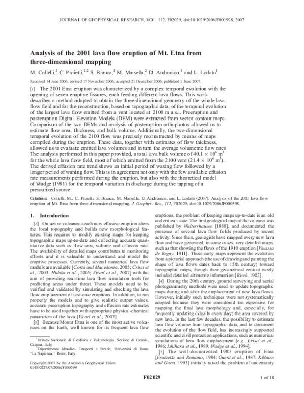
 Stefano Branca