Lunar and Planetary Science XXXVIII (2007)
2358.pdf
HIRISE HIGH-RESOLUTION, STEREO, AND COLOR PERSPECTIVES OF MARS NORTH POLAR
BASAL STRATIGRAPHY AND EROSIONAL PROCESSES. P. S. Russell1, S. Byrne2,5, K. Herkenhoff2, C.
Hansen3, K. Fishbaugh4, N. Thomas1, A. McEwen5, and The HiRISE Team. 1Physikalisches Institut, Univ. Bern, Bern,
Switzerland, 2Astrogeology Team, USGS, Flagstaff, USA, 3Jet Propulsion Lab, Pasadena, USA, 4International Space Science Institute, Bern, Switzerland, 5Lunar and Planetary Lab, Univ. Arizona, Tucson, USA. patrick.russell@space.unibe.ch
Introduction: A distinct darker basal unit (BU) underlying the polar layered deposits (PLD) is described from 1.46 m/pxl-resolution MOC images [1,2]. HiRISE [3] has made
several observations of scarps in the north polar deposits in
which much of the stratigraphic section from the lower BU
to the PLD surface is exposed. High resolution images (0.31.2 m/pxl), stereo anaglyphs, and 3-band color data (see [4]
for Fig.) provide an unprecedented, exciting new perspective
of Mars. Along with details that support or clarify previous
observations, many new stratigraphic, sedimentary, and erosional features within the BU are apparent in HiRISE data.
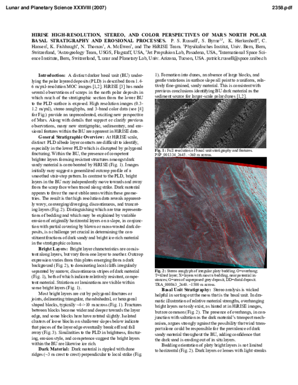
General Stratigraphic Overview: At HiRISE scale,
distinct PLD albedo layer contacts are difficult to identify,
especially in the lower PLD which is disrupted by polygonal
fracturing. Within the BU, the presence of competent
brighter layers forming resistant structures amongst dark
sandy material is corroborated by HiRISE (Fig. 1). Images
initially may suggest a generalized outcrop profile of a
smoothed stair-step pattern. In contrast to the PLD, bright
layers in the BU may independently move towards and away
from the scarp face when traced along strike. Dark material
appears to favor the most stable areas within these geometries. The result is that high resolution data reveals apparently wavy, converging/diverging, discontinuous, and truncating layers (Fig. 2). Distinguishing which are true representations of bedding and which may be explained by variable
erosion of originally horizontal layers on a slope, in conjunction with partial covering by blown or mass-wasted dark deposits, is a challenge yet crucial in determining the constituent fractions of dark sandy and bright ice-rich material
in the stratigraphic column.
Bright Layers: Bright layer characteristics are consistent along layers, but vary from one layer to another. Outcrop
expression varies from thin plates emerging from a dark
background (Fig. 2), to dominating local cliffs irregularly
separated by narrow, discontinuous stripes of dark material
(Fig. 1), both of which indicate relatively resistant, competent material. Striations or laminations are visible within
some bright layers (Fig. 1).
Most bright layers are cut by polygonal fractures or
joints, delineating triangular, rhombahedral, or hexagonal
shaped blocks, typically ~4->10 m across (Fig. 1). Fractures
between blocks become wider and deeper towards the layer
edge, and some blocks here have rotated slightly. Isolated
clusters of loose blocks on shallower slopes below indicate
that pieces of the layer edge eventually break off and fall
away (Fig. 3). Similarities to the PLD in brightness, fracturing, erosion style, and competence suggest the bright layers
within the BU are likewise ice rich.
Dark Material: Dark material is rippled with dune
ridges (~3 m crest to crest) perpendicular to local strike (Fig.
1). Formation into dunes, an absence of large blocks, and
gentle variations in surface slope all point to a uniform, relatively fine-grained, sandy material. This is consistent with
previous conclusions identifying BU dark material as the
sediment source for larger-scale polar dunes [1,2].
Fig. 1: Full resolution of basal unit stratigraphy and features.
PSP_001334_2645. ~360 m across.
Fig. 2: Stereo anaglyph of irregular platy bedding. O=overhang;
T=tilted layer; X=layers with most x-bedding, near potential instances; G=area of superposed grey deposit, DD=distal deposit.
TRA_000863_2640. ~1500 m across.
Basal Unit Stratigraphy: Stereo analysis is wicked
helpful in sorting out the mess that is the basal unit. In dramatic illustration of relative material strengths, overhanging
bright layers not only exist, as hinted at in HiRISE images,
but are common (Fig. 2). The presence of overhangs, in conjunction with saltation as the dark material’s transport mechanism, argues strongly against the possibility that wind transport alone could be responsible for the prevalence of dark
sandy material throughout the BU, adding confidence that
the dark sand is eroding out of in situ layers.
Bedding orientation of platy bright layers is not limited
to horizontal (Fig. 2). Dark layers or lenses with light streaks
�Lunar and Planetary Science XXXVIII (2007)
that appear straight and horizontal or fanning conformably
are common. The irregular layering and outcrop expression
of the BU make identification of true cross-bedding problematic. We have found several examples, particularly in a
few near-horizontal beds of dark material (Fig. 2,4), of curving light streaks that converge asymptotically downwards
and fan out as they curve upwards, truncating against what is
most often a thicker light streak or thin bright layer marking
the top of the dark bed (Fig. 4). Along with the sand-grain
size of dark material, these cross-bedded structures suggest
preservation of a paleo dune field in the stratigraphic section.
The light streak material was either also saltating, was deposited as a thin veneer concurrently with dark sand eolian
activity, or is simply frost highlighting bedding structures.
In conclusion, the major distinction between the similar
BU bright layers and the lower PLD is the presence of dark
sand amongst the former and their tilted and domed forms.
Non-uniform layering is seen at many scales, from crossbedded or truncated curving light streaks (<1 m thick, typically traceable up to 100 m) within dark deposits, to lenses
of sediment covered by tilting bright layers (100-300 m
across), to undulations of thinly veneered bright layer surfaces across the outcrop (e.g., 250 and 450 m crest to crest).
Observations require processes that can lead to non-horizontal and non-parallel bedding; alternating regimes of sand
abundance, mobility, and deposition, and temporary quiescence in which sand activity is replaced by dominantly ice
deposition; some erosion to plane off sloping sand layers;
but gentle enough transitions such that later ice-rich deposits
may be draped over sandy lenses.
Erosional Processes: Several currently or recently active processes of scarp modification have been identified.
Mass wasting appears to play a major role in erosion of
bright layers in the BU and fractured lower PLD. Given that
the total surface area of a cluster of fallen blocks (as described above and in [4]) is greater than that of an intact layer or scarp, the combination of mass wasting and subsequent
sublimation of fallen blocks may be more efficient in scarp
erosion than retreat due to sublimation alone.
The layering discussed so far is occasionally overlain by
aprons of light grey material on the order of 100 m wide and
of variable thickness (Fig. 2). These can usually be traced
high up the BU, occasionally to the base of the lower PLD.
The intermediate color may be due to a combination of icerich debris falls from the PLD and blown sand. Surface
characteristics and overall form suggest downslope movement has taken place but that the deposit may now be quite
competent, perhaps re-cemented after an event or period of
erosion. Depending on the outcrop, large volumes may be
tied up in these secondary deposits. In contrast, more continuous but smaller-scale erosion is evidenced by dark and
white aprons (up to 10 m wide) emanating from the base of
bright layers, often funneled by the fractures.
Several features present around a break in slope within
the BU are intriguing for their apparent indication of flow of
material assisted by liquid water or possibly ice. Most striking are sinuous individual, distributary, or braided rille segments (up to ~350 m cumulative length) with uniform banks
or levees (~2-3 m crest to crest) (Fig. 5). Beyond their cessations, some but not all rilles are associated with positive-relief deposits with lobate or fingered margins and flat tops
standing above the level of, and overlying, the surrounding
2358.pdf
dark dunes. (Fig. 2 includes such a distal deposit, but without prominent rilles.) This set of features appears to indicate
that highly fluidized debris flowed away from the polar scarp
and was deposited a short distance after leaving the slopes of
the steeper BU above. Lack of dune cover and stratigraphic
position suggest a relatively young age. Distal deposits occasionally have fine polygonal fractures and may still be ice
rich. Some rille segments emanate from the center of a pair
of wider, taller, parallel (spacing ~20 m) or V-formed levees
of light grey, markedly blocky material. They resemble lateral deposits associated with terrestrial glaciers or relatively
dry debris avalanches, and may be related to the grey aprons
mentioned above.
Geologic History: We suggest that during the period of
BU accumulation, a plentiful supply of sand was available
in the northern lowlands [5]. At high-obliquity, this sand was
readily transported to the BU’s location where surface sand
sheets and/or larger individual dunes developed [2]. With a
shift to low obliquity, any ice at low latitudes migrated poleward and was widely deposited at high latitudes, both cutting
off the sand source and delivering the ice-rich layers of the
BU. In the next transition to high obliquity, ice is removed
from more equatorward regions first, allowing sand to migrate in over the BU ice before it becomes unstable. Several
repetitions of this cycle formed the sequence of ice-rich
bright layers and sand-rich dark layers and lenses comprised
by the BU. When the sand supply ran out, continued deposition of successive ice layers occurred without intervening
sand sheets, forming the lower PLD [2]. Today’s intermediate obliquity favors deposition of the classical upper PLD.
References: [1] Byrne S. and Murray B. (2002) J. Geohys. Res.,
107 E6. [2] Fishbaugh K.E. and Head J.W. (2005) Icarus, 174, 444474. [3] McEwen A.S. et al. (2007) J. Geophys. Res., 111, in press.
[4] Byrne S. et al. (2007) LPSC XXXVIII. [5] Tanaka K.L. and
Kolb E.J. (2006) Mars Polar Sci. Conf. 4, #8098.
Fig. 3: Mass-wasting mode of icerich bright layers. ~200 m across.
TRA_000845_2645.
Fig. 4: Cross-bedding of white streaks in dark sandy layers.
TRA_000863_2640. ~400 m across.
Fig. 5: Sinuous rilles at the base of the BU. PSP_001412_2650. ~400
m across.
�
 Candice Hansen