1068201
QIXXXX10.1177/10778004211068201Qualitative Inquiryde Freitas et al.
research-article2021
Posthuman Creativities - Research Article
New Spatial Imaginaries for International
Curriculum Projects: Creative Diagrams,
Mapping Experiments, and Critical
Cartography
Qualitative Inquiry
1–15
© The Author(s) 2021
Article reuse guidelines:
sagepub.com/journals-permissions
https://doi.org/10.1177/10778004211068201
DOI: 10.1177/10778004211068201
journals.sagepub.com/home/qix
Elizabeth de Freitas1, Nathalie Sinclair2 , Kate le Roux3,
Armando Solares-Rojas4, Alf Coles5, and Oi-Lam Ng6
Abstract
This article explores the complex relational landscape of international partnerships where local and transnational
education objectives are entangled. We present a methodological practice for experimenting with diagrams and maps. Our
emphasis on spatial rendering of local/global relationality is intended to invite discussion about the postcolonial context of
international education work and the geopolitics of transnational curriculum. We pursue a diagrammatic and archipelagic
form of creative abstraction, which we present as a posthuman cartographic practice. To illustrate this practice, we focus
on a specific international curriculum development project funded by the World Universities Network.
Keywords
curriculum, mapping, diagramming, creativity, Glissant, mathematical imagination, place, spatial politics
Introduction
Enduring questions regarding the notions of place and
belonging, and the ways in which we are collectively earthbound, are newly diffracted through recent climatic shifts,
signalled by extreme weather events, ecological destruction, water and food insecurity, and increases in forced
migration (Latour, 2017/2018; Tsing, 2015). These conditions make more evident the dependency relations and
interconnectedness among all humans and nonhumans,
raising anew the tensions between situated knowledge practices and large-scale mobile curriculum projects, frequently
fuelled by pan-global corporate investment. The challenge
for international curriculum projects under these conditions
is to ensure that the interconnectedness forged at this postpandemic historical and geological moment allows for
inclusive forms of being together (and apart) that resist reinstating the detached, universalist, scalable gaze of curricular entailment. What kinds of collective perspectives might
allow us to engage with the “whole” of an international curriculum network under Anthropocene conditions while
attending responsively to the specificity and singularity of
each site, including its positioning in the history of colonization? How can we explore the complex, postcolonial
interconnectedness of partial, localized, and historically
situated perspectives across a collective international project or partnership?
In this article, we discuss creative diagrams and mapping
experiments that were used to explore these questions in a
specific international curriculum project. These diagrams
demonstrate the power of spatial imaginaries to “reshape”
human–earth relationality and open up alternative constellations of collectivity. The project, which is funded by the
World Universities Network (WUN),1 spanned seven farflung cities where eight participating universities aimed at
innovating the mathematics curriculum, attending to localglobal pressures, geographical, socioecological, and economic challenges. Although participating cities are
positioned as part of four continents—Asia, Africa, Europe,
and the Americas—we shift away from this habit of situating cities within continents, to explore how the cities form a
new archipelagic network amongst themselves, in which
capital and curriculum circulate and contract, exposing
1
Adelphi University, Garden City, USA
Simon Fraser University, Burnaby, British Columbia, Canada
3
University of Cape Town, South Africa
4
Mathematics Education Department, Cinvestav, Mexico City, Mexico
5
University of Bristol, UK
6
The Chinese University of Hong Kong, Shatin, Hong Kong
2
Corresponding Author:
Nathalie Sinclair, Simon Fraser University, 8888 University Drive,
Burnaby, British Columbia, Canada V5A 1S6.
Email: nathsinc@sfu.ca
�2
alternative relational and postcolonial landscapes. Drawing
on the Caribbean scholar Édouard Glissant, our aim is to
move away from framing the international network in terms
of continental centres and classical maps, towards an archipelagic practice of geographical reckoning that opens up
new spatial imaginaries about relationality. Thus, our aim is
to use alternative cartographic devices that break with classical colonial projections, pursuing a critical and creative
cartographic methodology. We experiment with alternative
mathematical rules for map making, so that the mathematics itself is used as an abstract engine for producing new
relations. In other words, mathematical meaning contributes to the “production of novel togetherness” (Whitehead,
1929/1978, p. 21). Our approach plays with alternate metrics, disrupting formal rules for network graphs and measurement, much like Ferreira da Silva (2017) has done with
alternative numeracies. In the context of the WUN project,
this led to diagramming experiments and what Deleuze
(1981/2003) calls “minor” mathematical practices that
allowed us to investigate different dimensions of the complex relational space of our transnational curriculum project
and to reveal new ways in which the whole earth is reconceived in such renderings.
We treat the diagram as a creative abstraction, a method
for thinking about knotted interactions, rather than a reductive form of representation (de Freitas, 2012a, 2012b). This
focus on creative abstraction is crucial when mobilizing the
diagram: “The essential thing about the diagram is that it is
made in order for something to emerge from it, and if nothing emerges from it, it fails” (Deleuze, 1981/2003, p. 159).
Rather than representing relations, the diagram becomes a
creative abstraction when it makes new realities possible by
unmaking previously determined claims. We take inspiration from the philosopher of mathematics Gilles Châtelet
(2000) who shows how inventive mathematical diagramming has been historically linked with new spatial imaginaries in other fields. He suggests that diagrams be studied
for their gestural and generative power, as they carve up
space and rearrange material relationships (de Freitas &
Sinclair, 2012). For Châtelet, the diagram is a kind of analogy machine, remixing matter and concept, and actualizing
the indeterminate potentiality of worlding activity.
In this article, we are focused on how diagramming
experiments might help us rethink the complex relationality
of an international curriculum development project. We
diagram the international project, attending to constraining
geohistorical structures of postcolonialism that persist in
many international curriculum projects. These diagrams are
network maps, exposing our assumptions about relationality, allowing project partners to interrogate the extent to
which their models of cooperation and networking continue
to be caught up in rigid rules about local-global, scale, interactivity, and so on. In a similar vein, Braidotti (2011) suggests that cartographic methods can be used to create “a
Qualitative Inquiry 00(0)
politically informed map of one’s historical and social locations” (p. 385) that can “enable the analysis of situated formations of power” and thus create potential locations for
resistance. Critical cartographic methods, in this instance,
should not be reductive representations of the real, but operate as provisional, responsive, and mobile devices, attending to nonlinear, dynamic relationality. In other words, the
cartographer seeks “to map out spaces where what-was
meets what-might-yet-be” (Kuntz, 2019, p. 85) in morethan-human milieus. This “what-might-yet-be” has ontoethical implications inasmuch as it aims towards social and
ecological change.
This article contributes much-needed specificity to this
kind of vision, by directly engaging with the metrical and
structural aspects of maps. Neither Braidotti nor Kuntz
offers any actual diagramming or mapping experiments.
Instead, they speak metaphorically about a new “cartographic method” without demonstrating how to play with
specific spatial renderings, unconventional mapping practices, alternative metrics, and graphical visualizations. We
aim to address that “silence,” and perhaps also to “follow
through” on these claims, by showing how diagrammatic
experiments in creative abstraction might be used methodologically. Only through actually experimenting with diagrams and spatial imaginaries, can we raise awareness
about part-whole relationality, local invariance, global animacy, and distributed proximities, all of which constrains/
enables a collaborative curriculum network. In the next sections, we discuss the WUN project and the archipelagic
thinking of Glissant, before revisiting standard mapping
conventions and alternative diagram experiments, considered, in part, through the lens of postcolonial and posthumanist practices.
Towards New Geographic
Relationalities
The WUN project involves a network of researchers and
their Universities, in different countries (Canada, Hong
Kong, Mexico, South Africa, the United Kingdom, and the
United States), pursuing different curriculum development
and research initiatives that all fall under the umbrella of
Innovating the Mathematics Curriculum in Times of
Change: Towards Local and Global Relevance. Our project
operates within the landscape of growing calls for innovation in the mathematics curriculum in the face of a rapidly
changing world (Skovsmose, 2019), particularly in relation
to the current climate crisis (Boylan & Coles, 2017; Yaro
et al., 2020) and to ongoing decolonizing efforts (Nicol
et al., 2020). Changes to migration patterns, global pandemics, and planetary climate change are felt locally and differentially across economic, biological, and affective scales.
These changes are inflected by colonial encounters through
the institutions implicated in addressing them, the methods
�3
de Freitas et al.
used to manage them, and the values underlying who or
what needs improving and when. The discipline of mathematics itself is also inflected by colonial encounters (Bishop,
1990; Joseph, 1987), not only through the sociomaterial
conditions of its practice across histories but also in the particular ways that the teaching of mathematics forced these
practices into a verbal and abstract lingua franca, thereby
performing erasures of meaning and context (see de Freitas
& Sinclair, 2020). The stated agenda of the project is to
make the curriculum relevant to learners, where relevance
entails connecting the curriculum to particularities of place,
context, and ecology. Relevance, however, is a moving and
mutating concept, itself changing in relation to place, connectivity, proximity, verticality, and other spatial/relational
concepts.
In considering these reimaginings of space and relationality, we have found resonance in the work of the Caribbean
thinker and poet Édouard Glissant (1928–2011), who asks
how we might “live the totality of the world as a temporal
layering of the linked histories of peoples” (Keeling, 2019,
p. 198). In his own spatial experiments, Glissant suggests
that we seek a poetics of networked relation, a kind of “toutmonde” that is not a closed whole, but an open archipelago
of moving parts. Glissant (1991/1997) offers a radically different approach to thinking about place and connectivity,
developing a distinct “archipelagic” philosophy of relation
that has been described as “simultaneously Deleuzian and
Caribbean” (Drabinski, 2019, p. 99, emphasis in original).
Glissant diffracts the world through the Caribbean Sea, pursuing a generative aesthetics of the earth. It seems to us that
this approach is promising as we try to imagine new political ecologies and corresponding forms of spatial practice,
mobility, and sense of place. Glissant (1991/1997) avoids
stories of ground and origin (like the tree or the top-down
hierarchy) that affirm filiation and lineage, and instead
develops a means of “com-prehending” a multiplicity, a
new way of thinking with parts and wholes, preferring the
neologism “donner avec” or “give-onto” rather than “grasp”
when making sense of relationality.
Connected to the image of an open archipelago of moving parts is his conviction that “The whole world is creolizing itself” (Keeling, 2019, p. 198). Working with and against
the classicisms and subjectivism of French education on the
island of Martinique, Glissant (1991/1997) uses the rich
lyrical creativity of the Creole language as a line of imaginative flight—not the speakers of the language, with the
right accent and proper vocabulary, but the language’s own
orality and opacity. Creolization, however, is not only a
politics of refusal, not only a form of resistance to the colonial plantation regime, but also involves an aesthetics of the
earth—in his words, creolization performs a “baroque
derangement” having to “renew itself on the basis of a
series of forgettings” (p. 69), creatively remapping historical relations across human and nonhuman boundaries and
rerouting the classical aesthetics. For Glissant, creolization
is more than linguistic and cultural expression because it
opens onto a political ecological perspective, where we are
engaged with an inherited earth and “écho-monde,” and
must reckon with “the integrating violence of contaminations” (p. 91). This is no simple spatial imaginary, but a
complex rhizomatic model with a corresponding ethics of
participation. Glissant remaps the earth from the situated
postcolonial space of the Caribbean Sea, moving with an
infinite “chaos-monde” that demands that we stop “englobing” in classical spherical renderings, and imagines instead
a rhizomatic “tout-monde” (or open totality). Glissant
invites alternative ways of thinking about relationality and
territory, focusing as he does on the opacity of the Caribbean
black beach, a middle territory of shifting tides, opening
onto the abyssal Atlantic, and the errant relay of speculative
thought. Glissant helps us rethink project participation in
terms of an errant entangled network of postcolonial paths
and relays.
We are struck by the force and novelty of Glissant’s spatial imaginaries and how they might help us both interrogate
and reimagine an international curriculum project. In particular, we ask, “What are the rhizomatic spatial imaginaries that might be engendered, to assist in reconceiving this
new relationality?” “How might ground-and-origin stories
of curriculum—pervasive in most countries—be replaced
by the lateral multiplicity of archipelagic moving flows?”
and “How might our curriculum project remain sensitive to
the ‘integrating violence of contamination’ that Glissant
also emphasizes, precisely through such reimagining of
spatial relationships?” We suspect that existing geographical imaginaries make such questions difficult to formulate,
precisely because we are wedded to conventional forms of
representing the relational landscape of an international network. Glissant’s ideas have recently sparked diverse work
across the social sciences, often as a form of correction to
isolationist tendencies in “island studies” which have
framed “the local” in simplistic ways (Stephens & MartínezSan Miguel, 2020). Following Glissant, and drawing also
on Deleuze and Latour, we consider next the complex diagrammatic nature of geographical mapping.
Spatial Imaginaries: Mapping and
Territory
Maps are ways of expressing and inventing local/global
relations and have functioned this way for centuries. Latour
(1988) recounts how mapping practices dangerously control what is taken to be in/visible, serving capitalist, imperialist, and commercial interests. He emphasizes the
destructive power of the mathematical gaze from elsewhere,
drawing static maps that fix and indeed misrecognize the
fluid relationality of the earth: “Scientists start seeing something once they stop looking at nature and look exclusively
�4
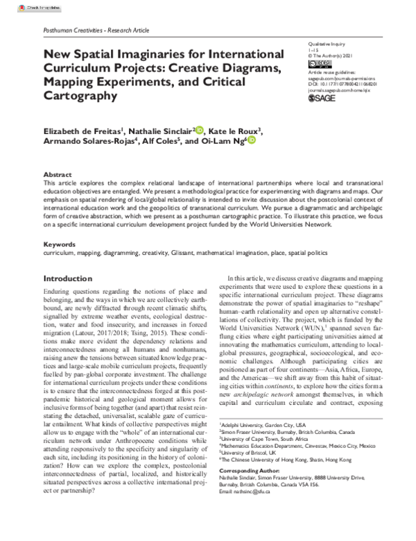
Qualitative Inquiry 00(0)
Figure 1. A 15th-century rendering of Ptolemy’s world map.
and obsessively at prints and flat inscriptions” (Latour,
1988). The flatness of the map is also crucial in invoking
and maintaining mastery; one can dominate a flat surface
where there are no hidden convolutions or shadows.
Whenever one needs to master a subject, says Latour, look
for the flat surfaces that enable that mastery—a map, a list,
a file, and a census. Mapping is a thoroughly political and
material practice.
For example, this 15th-century rendering of Ptolemy’s
world map (Figure 1) is constructed from his atlas
Geography (c. 150) and marks the significant places and
spatial relationships known to him. Working with Romanera survey data and a form of projection for latitude and
longitude, Ptolemy would have also relied on the mathematician Eratosthenes’s earlier cartography and theoretical
measure of the earth’s circumference. Our earliest copy of
this map comes from the 12th century and we don’t know if
the original much older Geography actually contained it—
he may have instead listed data, diagrams, and formal rules
for projection. In this article, we treat such maps as part of
cross-cultural investments in picturing the cosmos, that is,
in “cosmigraphics” (Benson, 2014).
Figure 2. A representation of a three-dimensional contour
map of Table Mountain, Cape Town.
Source. Mignon Wells, created using ArcGIS® software by Environmental
Systems Research Institute (2020a, 2020b) and data from City of Cape
Town (2018, 2019).
Maps like these convey particular perspectives about the
metric relations between human, nonhuman, and earth.
Mapping is a way of situating, projecting, and distributing
proximity and operates as a technology of existence.
Consider the contour map of Table Mountain (Figure 2), a
�5
de Freitas et al.
Figure 3. Mortality map of the Atoyac basin, Mexico (cancer, renal insufficiency, spontaneous abortion) (Rosado Zaidi, 2018).
geological feature by which the partner city of Cape Town,
South Africa, has come to be recognized internationally.
During colonial occupation, indigenous people were forced
from the lush slopes of Table Mountain. Colonial processes
of dispossession were cemented during apartheid when citizens not legally classified as “white” were forcefully
removed from these slopes (where market gardening was
productively conducted) to the sprawling, sandy “Cape
Flats.” These marks of difference endure in a time of postapartheid spatial planning, captured in the particular graphical intersections of the contour lines and partitioning of
property lines (see Motala, 2020). In this postcolonial context, the contours mark not only geological and ecological
differentiated elevations but also enduring material and
symbolic racial, socioeconomic, and linguistic hierarchies.
Once made, maps seem to show what is actually there, in
the world. The ultra-visible Table Mountain is decoded discretely into its changing elevations. But of course, as Latour
asserts above, and Glissant eloquently evokes, space is concretely inexhaustible, constantly open to new relays and
circuitry. For example, at another project site, near Mexico
City, the mortality map (Figure 3), tracks the flow of the
Atoyac River, showing how its waters move the pollution
produced by national and international factories discarding
dye and heavy metals through its tributaries (Solares-Rojas
et al., 2020). The river has not supported fish for over 20
years and there are emerging health effects on communities
living close by (Arellano-Aguilar et al., 2015). Indeed, the
map shows starkly the way in which mortality hotspots—
strewn like archipelagos across the Atoyac basin—transform the continuous current of water into discrete outbreaks
of disease. The poison-producing factories circulate death
across the entire region, through the giving-onto of the
water, the villages, and tiny tributaries that protect as well
as maroon.
New mapping practices are increasingly relying on
crowdsourcing technology that produces just-in-time global
positioning system (GPS) information. For instance, in
Figure 4, a mapping app, developed under the category of
“travel,” updates the live location of partner city Hong
Kong, where clashes between police and activists were frequently occurring, during the WUN project. With the mapping app, individuals who move quickly, sometimes
producing crowds, can know where tear gas or water cannons have been deployed and where police are advancing.2
Although we show a snapshot of the map here (Figure 4A),
it is a dynamically changing one, populated by emojis that
indicate the presence of tear gas (white speech-bubble),
police (a dog), and protesters (a worker in a hard hat).
Located on people’s smartphones, these maps can be
zoomed in or out, showing local dangers but also the flow
of movement that includes that of the person holding the
�6
Qualitative Inquiry 00(0)
Figure 4. (A) A live Hong Kong map during the protests on August 31, 2019. (B) Another map produced during a December 2020
protest.
Source. https://qz.com/1700205/real-time-mapswarn-hong-kong-protesters-of-poliec/
�7
de Freitas et al.
maps reveal novel spatializing practices and have been presented here to help convey the political-material nature of
maps. The different maps we have surveyed are creative
engagements in earth–human relations, embodying different possibilities and potentialities for suppression and resistance. In the next section, we bring Deleuze’s (1981/2003)
work on the diagram and the map together, emphasizing his
focus on the innovative and creative potential of diagramming as a technique for the “open conjugation of intensities” (Manning, 2009, p. 124).
Diagramming Relationality
Figure 5. An example of a stick chart from the Marshall
Islands (from the collection of the Phoebe A. Hearst Museum of
Anthropology at the University of California, Berkeley. Date not
known. Photo by Jim Heaphy).
smartphone. Given the difficulty of achieving accurate
enough information at real-time speed, other mapping practices have also emerged, that track change over relatively
short durations of time (15–20 min), but with high accuracy,
showing densities and speeds of crowds (Figure 4B). These
virtual maps are created through the labor of on-the-ground
immersive “runners” who observe, annotate, and transmit
information to the so-called “integrators” sitting in the control room. With the rapid deterioration of freedom of speech
in Hong Kong, these maps involve fluid and dynamic
responding to distributed, human-annotating/computergeolocating representations whose simultaneous updating
can also produce unexpected configurations, errors, and
dangers, as when the police begin to use the maps to control
dissent.
Fluidity and just-in-time human/geolocational feedback
are precisely what makes the maps used by the Marshall
Islanders over the last centuries so powerful as navigational
devices. Instead of providing an external, flattened map of
the islands and atolls, the mattang stick chart map was used
while at sea in the water as a kind of land/sea interface,
responding to the swells of the ocean, the location, and the
body of the navigator (Ascher, 1988). The tied arrangement
of sticks (see Figure 5) seems highly abstract, lacking signs
that tag it to particular places; however, these mattangs are
powerful diagrams for navigating specific oceanic relational movements in the south pacific.
We believe that there is something about the Mattang
that answers to the inventiveness that Braidotti (2011)
seeks, as discussed in our introduction, perhaps by virtue of
its abstract diagrammatic quality, and its emphasis on the
intensive dynamics of tides and wind between the apparent
fixed locations of land masses. All of these examples of
Standard spatial visualizations of part-whole relationality
reveal assumptions about hierarchical power distribution.
The dominant conceptualization of local and global scales
seems to cast the global as either rigid oppressive top-down
force (Figure 6A) or immaterial passive result that is simply
the sum of the parts (of the local), where those parts may
intersect or not (Figure 6B). The former might evoke a vertical causality, and the latter that of covering and containment. In the systems theoretic approaches of Maturana and
Varela (1980), patterns at the level of the whole system are
said to emerge from local actions and the vertical causality
is said to move in both directions. For example, the bottomup nature of phenomena and its emergent unity (i.e., how
the flight of each goose contributes to the V shape of the
flight pattern of the geese) is combined with the top-bottom
causal effects (how the V formation constrains the flight of
individual birds; Juarrero, 2002). And yet such reversing of
push and pull does not stray or alter the fundamental structure of the tree diagram or the Venn diagrams in Figure 6.
In the context of an international curriculum network,
the shape or content of a global curriculum would emerge
from the amalgamation of local curriculum innovation
efforts, tending to collate shared practices and/or shared
constraints, to the neglect often of local peculiarities. Such
an approach has its benefits—but it also has limitations,
especially as it continues to engender subtractive abstractions that transcend the specificity of place, and continues
to maintain a vertical structure. In other words, even when
models of international curriculum are generated from bottom-up sharing processes, these processes will remain
reductive through their subtractive actions, resulting in dislocated “curriculum standards,” despite the intention to
avoid these.
Latour (2009) underscores the important link between
spatial conceptualization and assumptions about the world
more broadly, when he writes, “Tell me what your position
on space is, and I’ll tell you who you are” (np). He contrasts
two conceptualizations of space, where the first is “the
inside in which reside objects and subjects,” and in the other
is “one of the many connections made by objects and subjects” (Latour, 2009, np, emphasis in the original). In the
�8
Qualitative Inquiry 00(0)
Figure 6. (A) Top-down hierarchical forces and (B) Venn diagram relationality.
former, which aligns with Figure 6, space is structured as a
container, containing other smaller containers, with no
agency or mobility, whereas in the latter conception, space
is engendered through mobilities, agencies, intensities. In
the former, space is abstract and passive; in the latter, space
is intensive and concretely inexhaustible. In the former, the
local is contained in the global. In the latter, the “global is a
form of circulation inside” (np) the local.
If the global is a “form of circulation inside”—rather
than a container—we must rethink the flow between local
and global and realize that the “whole,” or as Glissant states,
the “totality,” must be plugged into the web of particulars.
The goal is to disrupt the promise of or desire for transparency in the form of completeness or coherence. This can be
found, for example, in the rhizomatic networks of Deleuze
and Guattari (1980/1987), which are nonhierarchical and
composed of many entry points and mobile loops (you can
move a part and stick it somewhere else). Similarly,
Sloterdijk (2004/2016) draws on foam imagery that, unlike
two-dimensional networks of nodes and lines, expresses
multi-and self-similar cellular agglomerations.
These alternative diagrams envision distinctive potential
for new forms of relationality, opening up alternative ways
to stitch local knowledges and practices together. We caution that experiments in diagramming part-whole relationality are never safe or innocent. But precisely for this reason
we believe that experimentation with creative abstraction is
needed, aware that there is no fending off the all-consuming
forces of oppressive globalisms, but that there are significant differences between maps and their material implications. We don’t want to invest in a mathematical lingua
franca that translates all diverse practices into a reductive
abstraction, for doing so would amount to endorsing the
transcendent universalisms that inevitably inflict an oppressive ordering onto peoples and cultures. We can work
towards avoiding these traps if we turn to diagramming
experiments that put mathematics into the messy metamorphic zone of speculation.
Deleuze (1986) (citing Foucault) suggests that the diagram is an “abstract machine” which “makes no distinction between content and expression” (p. 34). In other
words, diagrams are said to “function as pragmatic exercises of finding out how something works . . . Such diagrams would be about realizing abstractions rather than
identifying the referent that is being stood-in-for” (de
Freitas, 2012a, p. 594). The power of the diagram is developed further in Deleuze and Guattari’s (1991/1994)
geophilosophy, where they pursue maps of an “intensive
spatium” that break with res extense (the extended thing)
that is typically presumed in most map making and metrologies of the earth. In other words, they ask us to experiment with the ways in which intensity animates the
apparent fixity of any map that claims to capture distance,
proximity, connectedness, and so on. This intensity refers
to flows of difference and variability, rather than to fixing
“in place” a particular configuration.
The term intensity is key for realizing the earth as an
ontogenerative ecology rather than a static passive sphere
or globe; intensive forces are precisely what resist the rigidifying tendencies of map making and allow for a rethinking
of spatial relationality. Indeed, intensity might be the key
concept for thinking the whole without always thinking the
universal obliteration of the local. Intensity is what makes
the abstract line in a diagram quiver with indeterminacy and
resistance; it thereby opens onto the poetic, speculative, and
creative capacities of the earth and the human (in excess of
the line). Intensity is never “contained” in any one locale or
place, always inflecting and twisting the relational landscape. As Rousell (2021) explains, the intensive quality of
Deleuze’s “cartography-art” makes “cartography an art of
transitions and forgettings rather than one of historical
memorializations, biographic remembrances, or archeological excavations” (p. 4). For Deleuze, the map is not simply
an impoverished representation of the real because “extensive trajectories of movement are inseparable from intensive processes of becoming-other, and the purpose of a
�de Freitas et al.
Figure 7. The trade triangle map.
cartography-art is to render the ‘mutual presence’ of these
trajectories and becomings through techniques of making
visible, audible, sensible, or otherwise palpable” (Rousell,
2021, p. 5). And part of what is brought into presence is the
affective relations and resonances in a situation (Barry,
2017, p. 331).
For Glissant (1991/1997), however, intensive relationality sustains the flow of onto-epistemological resistance to
rendering the Other transparent and legible. This refusal to
submit to representation is part of Glissant’s “poetics of
opacity” that expresses a nomadic and differential view of
earthly belonging, leading to his embrace of a relational
network or “open whole” associated with the Caribbean
archipelago. Thus, he seeks a sense of a “totalité,” but also
reckons with fragmented forms of belonging together and
the history of postcolonial violence (de Freitas et al., 2022).
Inspired by Glissant and Deleuze, we aim here to explore
novel forms of relationality and experiment with diagramming practices that might engage with the intensive spatium, in all its opacity.
Project Diagrams
In this section, we present some of our diagramming experiments. We first generated diagrams under the constraint that
they be constructed with lines and nodes, realizing that
enabling constraints are necessary in creative work.
Everyone was then asked to draw on diverse mathematical
concepts that might break with standard conventions and
help reimagine local and translocal. We encouraged playful
and disobedient diagramming techniques. In each case, we
used the diagrams to elicit discussion during team meetings
and to raise awareness about unexamined forces that were
structuring the international network. These discussions
occurred during monthly meetings on Zoom, where we
9
shared and discussed project goals across our diversely situated locales (Bristol, Cape Town, Hong Kong, Manchester,
Mexico City, Vancouver, and Edmonton). The diagrams are
not offered as answers or solutions, but used as devices for
exploring new spatial imaginaries and the power of creative
abstraction to engender new insights.
These diagrams are of course personal expressions composed by network members, reflecting situated perspectives, engendered from distinct geographical locations.
These are creative abstractions, not intended as exhaustive
representations, but as partial and fragmented maps of the
archipelagic network. The challenge was to think with the
“trans-positions” of our current network by mobilizing
alternative metrics and graphics, in such a way that diverse
forms of relationality became visible. Like all maps, these
are ground in both the particular and the general, exploring
spatial imaginaries at the scale of the network and the earthbound. These maps, however, contest the conventions of
center and periphery that dominate Eurocentric mapping
traditions, where the “continent” is the center and the scattered islands are the periphery. Given the persistence of
such traditions, and the postcolonial reality they document,
we have deployed the speculative capacity of mathematics
itself to furnish us with new spatial imaginaries and new
modes of documenting our relationality. We remind the
reader, however, that mathematics does not transcend place
and cultural tradition, but rather that mathematics entails
habits of creative abstraction, which emerge from within
“places” everywhere (de Freitas & Sinclair, 2020). This
approach is meant to bring mathematics into the fold of
critical geography (i.e., Soja, 1996), as not simply that
which entrenches the status quo, but as a methodological
tool for breaking up rigid dogma and thinking otherwise
(Badiou, 2006). By mobilizing key ideas from knot theory,
topology, and projective geometry, we have tapped the
force of mathematics to creatively play with form, structure, and map.
The first two diagrams attend to north–south distributions of power and knowledge. They thus enable us, as a
network, to engage directly with tensions associated with a
mathematics curriculum that is assumed to be universally
relevant. The diagram shown in Figure 7 uses the longitude–latitude coordinates of all seven cities, with many
clustering around latitude 50° N. Notably, Edmonton and
Hong Kong are located somewhat symmetrically around
the meridian, with approximate longitude 114° W and 114°
E. The “equator” and “prime meridian” are represented as a
heavy cross carving up the space into quadrants, evoking
grids and separation, and Euro-Christian colonial conquests. The colonial history of this kind of geometry is
emphasized in the marking of north–south quadrants and
the making of the subaltern—literally, the rank below the
“captain” of the north. Lines are drawn to mark the “trade
triangles”—a term used to describe the trading paths of
�10
capital and commodity movement from the United Kingdom
to Africa to the Caribbean. These trade triangles ensured
there was never an empty boat traversing the black Atlantic
trade routes, as slaves, cotton, and mortar were carried from
node to node along the paths of the trade triangle. By showing how our network was situated in the afterlife of slavery
and colonial trade, the map made evident how most of the
participating cities clustered around latitude 50° N, underscoring the socioeconomic status of participating institutions and the correlation of SES with patterns of geographic
settlement.
The lines that leave the flat page on either edge in Figure
8 evoke another possible polygon, another trade route,
where east and west reengage in the opaque space behind
what is made visible here, connecting Hong Kong to
Vancouver. This link gestures toward an open whole, puncturing the insular triangle, fracturing the singular ocean
back into its making parts. It also weaves in current academic/supervisory filiations, pointing as it does to the lineage of scholarship between participants in Hong Kong and
Vancouver. We must ask, “How does our network handle
the multiple filiations, including colonial and academic, at
play?” and “How can we move from filiation to alliances, as
Glissant suggests?” One possibility can be found in the way
the map disrupts the convention of encoding east–west as
left–right, as Hong Kong is on the far right and Vancouver–
Edmonton on the far left. Such a simple gesture raises spatial awareness.
In the next diagram shown in Figure 8, projective geometry was used to create an inversion puzzle, producing a
geometric inversion between line and circle. Inversion is a
kind of transformation that has the effect of turning the
plane inside out about a given circle—thereby once again,
but differently, disrupting north–south spatial imaginaries.
The idea was invented by Jacob Steiner (1796–1863) and
led to new branches of mathematics. To invert a number in
arithmetic usually means to take its reciprocal. The process
of inversion can be used in geometry to transform a difficult
problem into something more tractable. To make an inversion into an involution, one maps the center of the circle to
an imagined point at infinity, thereby opening up the finite
rendering to an infinite outside. Once chosen, the inversion
of straight things (segments joining two nodes, rays and
lines) will almost always be curved things (like an arc or a
circle) that pass through the center of the circle of inversion.
In other words, points that are infinitely far away curl into
the finite middle. There is a measured precision in this
inversion diagram, in the stipulation regarding the ratio and
location of line and circle. Geometric inversion correlates
any point (Q) inside a circle (center O, radius r) with one
outside the circle (P), such that OP / r = r / OQ. The closer
the point Q is to the center, the further away the point P is
projected, until the circle’s center correlates with a point at
infinity. This exercise of inversion in mapping upturned the
Qualitative Inquiry 00(0)
Figure 8. The inversion map.
usual expectation of the relationship between node and link
in a network—where the link expresses Glissant’s idea of
Relation, that which precedes the nodes, rather than arising
from them. This inversion functions as a creative abstraction—a geometry of duality—that forces us to posit a new
perspective from which Edmonton and Cape Town, for
example, might share in unexpected proximities. The circle
of inversion can be chosen arbitrarily, thus performing the
crucial act of contingency, instantiating that point of view,
the force, that will produce the relation.
The inversion map also raises questions about relationships between center and periphery and the ways in which an
infinity (imagined but no less powerful) occupies our sense
of place. The circles/nodes of Vancouver and Manchester
intersect, capturing the joint writing habits of the co-authors
de Freitas and Sinclair. As lines become circles under the
inversion transformation, the bidirectional flows of goods
and slaves that made the trade triangle now devolve into vortexes, dethroned of their power to circulate in the same way.
After an inversion, everything that was inside the circle will
move out and vice versa. Objects that might have been far
apart on the outside will grow closer on the inside, and vice
versa. Choosing a circle of inversion that includes Europe,
for example, would perform a scattering of former alliances
and might redistribute other proximities. How do we take
care of the new lines—new edges—we’ve made? How do we
make sure that new trade routes of power and knowledge are
nonextractive and reciprocal? Specifically, how might
�11
de Freitas et al.
curriculum developed in Bristol be handled, as it moves
along the edges? How do we make sure that it is given its
ontological dignity and allowed its ontogenesis with other
researchers, in other locations? These two diagrams use
graphical elements (grid/quadrature, polygonal shapes, inversion) that are mathematical in their rendering and conceptualization. But they also generate new ways of thinking,
speculating about new relations, new future movements.
Any measuring practice is somewhat paradoxically imbricated with matter, and thus ultimately both objective and subjective, abstract and concrete, collective and singular, global
and local. We see this map as a “creolisation” process that
breaks with colonial mathematics and instead folds mathematics into a critical geography, as a detector of violence and
contamination. In refusing the typical tame and clean measures of Euclidean geometry, this map discharges messy
mathematical relationships that cleave to the world without
their Western units.
Diagrams in Figures 9 and 10 draw attention to the
earth’s animacy and agency. The first (Figure 9) sets the
seven sites as though they formed a fish in its watery milieu,
a creature that swims the diffractive sea of Glissant. In this
diagram, Bristol is the all-consuming mouth and Cape
Town the eye. The spiral around Hong Kong stresses the
current crisis around its political status and independence,
as the “rent” on its land expires, shifting the island’s
“belonging” from the United Kingdom to China. The network lines cross over/under to emphasize movement or
blockage, and the fish opens onto the sea with these overlays, so that the creature passes through that which passes
through it. The sea is within the fish—as though animacy
and flow were one and the same.
The diagram in Figure 10, made with a 3D (three-dimensional) pen, expresses the different project nodes as 3D lines,
color-coded with six different looped strings of wax, and
creates an alternative way of characterizing the intensive
flow of ideas across the network. This map puts the sites of
the project into motion along the line, so that all is entanglement. Place is stretched across the spatiotemporal network,
as pure entanglement. Turning nodes, as things, into loops,
as operators, is the quintessential move of modern abstract
algebra, which focusses not on the properties of objects but
on their behaviors. With Glissant, these loops express the
archipelagic, temporal layering of linked histories of project
participants. Instead of only relations of proximity and
power, we produce intersections, overlappings, knotting,
and evoke temporal duration. The 3D pen allows for a
map—like the Marshall Islanders’ Mattang—that is haptic
and volumetric and is used here to emphasize some of the
collaborative histories among the network, in which curricular ideas have been shared. The topological orientation of
this diagram does away with Euclidean concerns with imperial distance and fixed location. In the case of the 3D pen, the
droopy wax hardens over time in-formation with gravity,
Figure 9. The fish map.
Figure 10. 3D pen drawing.
susceptible to the local conditions of moisture, as they
congeal.
The petal diagram (Figure 11) points to alternative
ways of working with grids and entails a legend and annotation. This is a process map and documents the unfolding
relationship between earth, measure, and the imagination,
the latter signaled through the emergence of an “escape
petal” and the unstable asymmetric crystal formations in
the lower corners. This circular grid enables a process diagram of conceptual de/re/composition, whereby earth
(coded by circles) begins in an intensive layering of bubbles in the upper left portion of the diagram, then breaks
apart into petals and later into an unstable crystal formation of diamonds. The diamonds are both the mark of a
brutal violent history of colonial mining, while also the
birth of a fragile form, a creative abstraction. The legend
indicates that the diamonds are code for “hypothesis”
which is itself a powerful mode of speculative thought,
�12
Qualitative Inquiry 00(0)
Figure 12. The storm cloud map.
Figure 11. The petal map.
particularly in mathematics. The diagram shows how
time’s arrow is split, announcing the formal force of indeterminacy and vagueness, as hypotheses are materially
engendered. The static, flat, and snapshot-like maps of the
Earth that we usually see, which seek to capture identity
and location, are turned into ontogenetic operations, tracking the dynamics of conceptual gains and losses: Petals are
shown to metamorphosize, hybridize, and crystallize,
renewing themselves as they seed and scatter.
The dotted lines on the paper invite the eye to move along
actual arcs, but also to see potential ones that have not yet
been traced—gesturing again to a tout-monde of open navigation. The petal diagram also shows another kind of part–
whole relationship, among circle, petal, diamond, enabled
by the specificity of the alternative grid structure, in a
Glissantian “baroque derangement.” Given the persistence
of such traditions, and the postcolonial reality they document, this map proffers a new spatial imaginary and a new
mode of documenting our relationality. In petal logic, there
is no origin, no Cartesian coordinate grid.
The diagram in Figure 12 tracks project participation as
kinetic energy, so that the creative capacity and production
of the project is captured in a brewing storm cloud over
time. This map is based on meteorological methods for
studying atmospheric effects like the emergence of thunderhead clouds. The project sites have been positioned on a
plane, while the third vertical axis marks the evolving collective effort of the collaboration, as it gathers steam from
different sites at different times over the life of the project.
This map tracks the intensive flow of energy between participants, in the process of curricular innovation.
Atmospheric formations like this are not simple aggregates
of parts and require new mapping methods to gather the
newly distributed proximities. This last diagram points to
the complexity of collective efforts, and the modes by
which ideas, engendered in one location, can seed clouds
with particular powers under shifting conditions. This diagram raises questions about how to modulate these atmospheric processes and perhaps begin to understand our
project aims under new climate regimes.
Closing Comments
Latour (2015/2017), Haraway (2016), and Tsing (2015) remind
us that the earth is fully situated and we need to grapple with its
finitude—indeed, echoing Whitehead (1929/1978), Latour
suggests that the earth “inflicts” on humans their return from
the infinite realm of ideals, back into the folds of the material
finite world. He states repeatedly, “The earthbound have to
explore the question of their limits” (pp. 290–291). For Latour,
“the infinite realm of ideals” leads all too easily to abstractions
that erase the finite particular and impose the general model.
Despite these caveats, we think it essential to affirm the creative power of abstract forms as alchemic expressions that are
powerfully earthbound. Rather than blame abstraction for its
detachment from the real, we show how abstract forms can be
�13
de Freitas et al.
a source for thinking creatively about earthly spatial dynamics.
In particular, we show how mathematics is quite useful in posthuman projects, for those intent on “imagining otherwise,”
furnishing the “wherewithal” to create hypothetical spaces that
have never been experienced—spaces with 17 fractional
dimensions; spaces of no continuity, of infinite stretchability;
spaces where inside is outside or where there is no other side.
In that spirit, we treat the diagrams included in this article as
playful attempts to refold or relay Glissant’s “totality” through
the mathematical possibilities of a transcurricular project
focused on mathematics. These diagrams were shared and discussed during displaced zoom meetings, allowing the network
partners to engage directly with the spatial politics of our collaboration. They kept us from settling into easy positions about
curriculum and collective efforts.
These mapping experiments were also inspired by Mbembe’s
(2017) insistence that more attention needs to be paid to how
past and present colonial encounters change us all, no matter
where we are. He also argues that sustained reflection on transnational encounters offers the potential to “rehabilitate singularity and difference” (Mbembe, 2017, p. 158). Such injunctions
can help frame the work of international curriculum projects,
especially projects that are focused on mathematics, which harbours within it so much potential for producing and imposing
harmful universals. Our focus on spatial imaginaries as a fertile
conceptual ground for rethinking our own curriculum project
aims not to produce new map-making rules, but to encourage
cartographic gestures that animate and explore the differenc/tiating earth. Indeed, we are not looking for best practices in curriculum design or to export course outlines. Furthermore, we are
committed to exploring the way in which mathematics itself is
more than a global discipline practiced in local styles (Cartier,
2012), being also a powerful force for creative abstraction,
enhancing our capacity to imagine new forms of inclusive relationality. Recognizing that curriculum involves an alchemical
process that transforms knowledge for the purpose of instruction, as Popkewitz (2004) argues, and that contemporary mathematics curricula frame mathematics as a “stable structure of
conventional ideas that elide the social and cultural mooring of
mathematical knowledge” (p. 17), we seek to intensify this
alchemy by pressing on the material, earthly moorings as well,
moving toward an idea of curriculum as spatial imaginary. In our
project, such a curriculum would begin by tethering mathematical notions to their times and places, but then also indulge the
mathematical propensity for speculative lines of flight and fancy,
no less fully situated for being imagined.
In the diagrams we produced (shown in Figures 8–12), we
sought to mobilize creative abstractions that could help us
create new spatial imaginaries, that is, new ways of making
and multiplying relations. These maps may appear rather
simple and therefore at odds with the serious and complex
nature of our current precarious conditions, which emerged
first and most intensely in the “ruins” or “devastation” or
“disturbances” of colonial encounters (Comaroff & Comaroff,
2012; Connell, 2007; Tsing, 2015). But in seeking a mathematics in the middle, we mean to be very serious about the
possibility and productivity of divesting ourselves of the simplistic relations of abstract/concrete, local/global, and top/
down that too often guide collaborative educational projects,
whether they be intercontinental like ours, or cross-national.
While the “performances of livability” (Tsing, 2015, pp.
157–158) in precarity may be different in different contexts,
the ultimate horizon, for Mbembe (2017), is the same, that is,
“how to belong fully in the world” (p. 176). This “world” is
one of “the divergent, layered, and conjoined projects”
(Tsing, 2015, p. 22) that involve all humans and also nonhumans, including the creative abstractions of fungi. We argue
that the geomathematical commitment of the mapping methodology we explored in this article can be productive in
thinking experimentally about such conjoined projects.
Declaration of Conflicting Interests
The author(s) declared no potential conflicts of interest with respect
to the research, authorship, and/or publication of this article.
Funding
The author(s) disclosed receipt of the following financial support
for the research, authorship, and/or publication of this article: This
project is funded by the Worldwide Universities Network (WUN).
The title of the grant is “Innovating the mathematics curriculum in
times of change: towards local and global relevance”.
ORCID iDs
Nathalie Sinclair
https://orcid.org/0000-0003-0600-7062
Oi-Lam Ng
https://orcid.org/0000-0003-3736-7845
Notes
1.
2.
See https://wun.ac.uk/wun/research/view/innovating-the
-mathematics-curriculum/
The app is later banned by China (for encouraging illegal
activities): https://www.bbc.com/news/technology-49919459
References
Arellano-Aguilar, O., Solis-Angeles, S., Serrano-García, L.,
Morales-Sierra, E., Mendez-Serrano, A., & MonteroMontoya, R. (2015). Use of the zebrafish embryo toxicity test
for risk assessment purpose: Case study. Journal of Fisheries
Sciences, 9(4), 52–62.
Ascher, M. (1988). Graphs in cultures: A study in ethnomathematics. Historia Mathematica, 15, 201–227.
Badiou, A. (2006). Mathematics and philosophy. In S. B. Duffy
(Ed.), Virtual mathematics: The logic of difference (pp. 12–
30). Clinamen Press.
Barry, K. (2017). Diagramming: A creative methodology for tourist studies. Tourist Studies, 17(3), 328–346.
Benson, M. (2014). Cosmigraphics: Picturing space through time.
Abrams Books.
�14
Bishop, A. (1990). Western mathematics: The secret weapon of
cultural imperialism. Race & Class, 32(2), 51–65.
Boylan, M., & Coles, A. T. (2017). Is another mathematics education possible? An introduction to a Special Issue
on Mathematics Education and the LIVING WORLD.
Philosophy of Mathematics Education Journal, 32. https://
research-information.bris.ac.uk/en/publications/is-anothermathematics-education-possible-an-introduction-to-a-sp
Braidotti, R. (2011). Nomadic theory: The portable Rosi Braidotti.
Columbia University Press.
Cartier, P. (2012). Mathématiques sans frontières [Mathematics
without borders]. In N. Andruskiewitsch (Ed.), Actas de la
Academia Nacional de Ciencias, Tomo XV (pp. 27–57).
Academia Nacional de Ciencias.
Châtelet, G. (2000). Figuring space philosophy, mathematics, and
physics. Springer.
City of Cape Town. (2018). 10m digital elevation model [Data
set]. http://odp.capetown.gov.za/
City of Cape Town. (2019). Streets [Data set]. http://odp.capetown.gov.za/
Comaroff, J., & Comaroff, J. L. (2012). Theory from the south:
Or, how Euro-America is evolving toward Africa. Paradigm.
Connell, R. (2007). Southern theory. Polity Press.
de Freitas, E. (2012a). The classroom as rhizome: New strategies
for diagramming knotted interaction. Qualitative Inquiry,
18(7), 557–570. https://doi.org/10.1177/1077800412450155
de Freitas, E. (2012b). The diagram as story: Unfolding the eventstructure of the mathematical diagram. For the Learning of
Mathematics, 32(2), 27–33.
de Freitas, E., & Sinclair, N. (2012). Diagram, gesture, agency:
Theorizing embodiment in the mathematics classroom.
Educational Studies in Mathematics, 80(1–2), 133–152.
https://doi.org/10.1007/s10649-011-9364-8
de Freitas, E., & Sinclair, N. (2020). Measurement as relational,
intensive and analogical: Towards a minor mathematics. The
Journal of Mathematical Behavior, 59, 100796. https://doi.
org/10.1016/j.jmathb.2020.100796
de Freitas, E., Trafi-Prats, L., Rousell, D., & Hohti, R. (2022). A
poetics of opacity: Towards a new ethics of participation in
gallery-based art projects with young people. In L. Trafi-Prats
& A. Castro (Eds.), Visual participatory arts-based research
in the city. Routledge. in press.
Deleuze, G. (1986). Foucault (S. Hand, Trans.). University of
Minnesota Press.
Deleuze, G. (2003). Francis Bacon: The logic of sensation (D.
W. Smith, Trans.). Continuum. (Original work published
1981)
Deleuze, G., & Guattari, F. (1987). A thousand plateaus: Capitalism
and schizophrenia (B. Massumi, Trans.). University of
Minnesota Press. (Original work published 1980)
Deleuze, G., & Guattari, F. (1994). What is philosophy? (H.
Tomlinson & G. Burchell, Trans.). Columbia University
Press. (Original work published 1991)
Drabinski, J. E. (2019). Glissant and the middle passage:
Philosophy, beginning, abyss. University of Minnesota Press.
Environmental Systems Research Institute. (2020a). ArcGIS desktop 10.8 with terrain tools toolbox. https://www.esri.com/en-us
Environmental Systems Research Institute. (2020b). ArcGIS Pro
2.5. https://www.esri.com/en-us
Qualitative Inquiry 00(0)
Ferreira da Silva, D. (2017). 1 (life) ÷ 0 (blackness) = ∞ − ∞ or ∞ /
∞: On matter beyond the equation of value. e-flux Journal, 79.
http://www.e-flux.com/journal/79/94686/1-life-0-blacknessor-on-matter-beyond-the-equation-of-value/
Glissant, É. (1997). Poetics of relation (B. Wing, Trans.).
University of Michigan Press. (Original work published 1991)
Haraway, D. J. (2016). Manifestly Haraway. University of
Minnesota Press.
Joseph, G. G. (1987). Foundations of Eurocentrism in mathematics. Race & Class, 28(3), 13–28.
Juarrero, A. (2002). Dynamics in action: Intentional behaviour as
a complex system. MIT Press.
Keeling, K. (2019). Queer times, Black futures. NYU Press.
Kuntz, X. (2019). Qualitative inquiry, cartography, and the promise of material change. Routledge.
Latour, B. (1988). On drawing things together. In M. Lynch &
S. Woolgar (Eds.), Representation in scientific practice (pp.
19–68). MIT Press.
Latour, B. (2009). Spheres and networks: Two ways to reinterpret
globalization. Harvard Design Magazine, 30(1). http://www.
harvarddesignmagazine.org/issues/30/spheres-and-networkstwo-ways-to-reinterpret-globalization
Latour, B. (2017). Facing Gaia: Eight lectures on the new climatic
regime (C. Porter, Trans.). Polity Press. (Original work published 2015)
Latour, B. (2018). Down to earth: Politics in the new climatic
regime (C. Porter, Trans.). Polity Press. (Original work published 2017)
Manning, E. (2009). Relationscapes. MIT Press.
Maturana, H., & Varela, F. (1980). Autopoiesis and cognition: The
realization of the living. D. Reidel Publishing.
Mbembe, A. (2017). Critique of black reason. Duke University
Press.
Motala, S. (2020). A place-based response to Fikile Nxumalo.
Critical Studies in Teaching and Learning, 8(1), 50–59.
Nicol, C., Gerofsky, S., Nolan, K., Francis, K., & Fritzlan, A.
(2020). Teacher professional learning with/in place: Storying
the work of decolonising mathematics education from
within the colonial structure. Canadian Journal of Science,
Mathematics and Technology Education, 20(2), 190–204.
https://doi.org/10.1007/s42330-020-00080-z
Popkewitz, T. S. (2004). The alchemy of the mathematics curriculum: Inscriptions and the fabrication of the child. American
Educational Journal, 41(4), 3–34.
Rosado Zaidi, S. J. (2018). La transformación del hábitat humano
en el modo de producción capitalista: una aproximación
teórico metodológica de la fractura metabólica entre el
sujeto y la naturaleza [Human habitat transformation in the
capitalist mode of production: A theoretical and methodological approach to the metabolic fracture between subject and
nature] [Unpublished bachelor thesis, National Autonomous
University of Mexico].
Rousell, D. (2021). A map you can walk into: Immersive cartography and the speculative potentials of data. Qualitative Inquiry,
27, 580–597. https://doi.org/10.1177/107780042935927
Skovsmose, O. (2019). Crisis, critique and mathematics.
Philosophy of Mathematics Education Journal, 35, 1–16.
Sloterdijk, P. (2016). Foams: Spheres, Volume III: Plural spherology
(W. Hoban, Trans.). MIT Press. (Original work published 2004)
�de Freitas et al.
Soja, E. W. (1996). Thirdspace: Journeys to Los Angeles and
other real-and-imagined places. Blackwell.
Solares-Rojas, A., Coles, A., Arellano-Aguilar, O., MendezSerrano, A., Xolocotzin, U., Benavides-Lahnstein, A. I.,
Guerra-Ramos, M. T., & Montero-Montoya, R. D. (2020).
GCRF “Community, Science and Education: An interdisciplinary perspective for facing ecological crises in Mexico and
South America” Network (Grant Ref: EP/T003545/1). UK
Research and Innovation. https://gtr.ukri.org/projects?ref=EP
%2FT003545%2F1
Stephens, M., & Martínez-San Miguel, Y. (2020). Contemporary
archipelagic thinking: Toward new comparative methodologies and disciplinary formations. Rowman & Littlefield.
Tsing, A. L. (2015). The mushroom at the end of the world: On the
possibility of life in capitalist ruins. Princeton University Press.
Whitehead, A. N. W. (1978). Process and reality: An essay in
cosmology. Macmillan Publishers. (Original work published
1929)
Yaro, K., Amoah, E., & Wagner, D. (2020). Situated perspectives
on creating mathematics tasks for peace and sustainability.
Canadian Journal of Science, Mathematics and Technology
Education, 20, 218–229. https://doi.org/10.1007/s42330-02000083-w
Author Biographies
Elizabeth de Freitas studies the social and material conditions of
scientific and mathematical activity, exploring philosophical, historical, and anthropological perspectives. She is particularly
focused on the sensory dimensions of learning processes. Recent
publications include Mathematics in the middle: The relationship
between measurement and metamorphic matter (https://revistes.
ub.edu/index.php/matter/article/view/35888) and New empiricisms in the Anthropocene: Thinking with speculative fiction
15
about the future of social inquiry (https://journals.sagepub.com/
doi/full/10.1177/1077800420943643).
Nathalie Sinclair is Distinguished University Professor in the
Faculty of Education at Simon Fraser University. She is interested
in the use of digital technologies in mathematics education, especially as it concerns the body, as well as in the history and philosophy of mathematics.
Kate le Roux is an Associate Professor in Language Development
at the University of Cape Town, South Africa. Her academic work
converges at the intersection of language, mathematics, and the
learning of disciplinary knowledge in science and engineering.
For her focus on equity, access, identity, power, and knowledge in
multilingual education contexts, she draws on critical scholarship
in mathematics education within the sociopolitical, multilingualism and multimodality for learning, and Southern Theory.
Armando Solares-Rojas is a researcher at the Department of
Educational Mathematics at Cinvestav, Mexico. His two ongoing
research lines are mathematical modelling and the study of mathematical knowledge in contexts of cultural diversity. Currently, he
is the principal investigator of a project funded by the EPSRC UKRI (Grant Ref: EP / T003545 / 1) on constructing educational
responses to the socio-ecological crises faced by Latin American
communities.
Alf Coles is a Professor of Mathematics Education with research
interests in the parallels between teacher and student learning and
the facilitation of that learning. He is also involved in work on curriculum innovation and the potential role of socio-ecological
issues in the mathematics curriculum.
Oi-Lam Ng is an Assistant Professor in the Department of
Curriculum and Instruction at the Chinese University of Hong
Kong. Her research interests include technology innovations in
mathematics education, language and mathematics discourse,
mathematics teacher noticing, and STEM education.
�
 Kate Le Roux
 Oi-Lam Ng