1
Herculaneum
DOMENICO CAMARDO AND SARAH COURT
Herculaneum is an archaeological site on the
Bay of Naples in southern Italy, best known as
the Roman town that was destroyed – along
with POMPEII – by the eruption of VESUVIUS in
79 CE. It could be argued that the discipline of
archaeology began at Herculaneum in the
eighteenth century, when excavation of the
Roman town was accompanied by scientific
approaches and technical documentation.
Whether or not this is true, there is no doubt
that the rediscovery of Herculaneum – and its
material culture – had an enormous impact on
European culture (Pace 2000). Once the major
focus of excavation campaigns during the
early twentieth century, Herculaneum has
since become overshadowed in the public
imagination by Pompeii, but its particular
preservation – from organic materials to upper
floors – means that it makes a significant contribution to understanding daily life in the
Roman world. Today only about a third of the
town has been fully excavated, and this area
largely contains private residences. A neighboring archaeological area contains a corner of the
Villa of the Papyri, while to the north lies the
theater, still accessible only by eighteenthcentury tunnels.
HERCULANEUM’S ORIGINS
The legend of Herculaneum’s foundation was
described by Dionysius of Halicarnassus
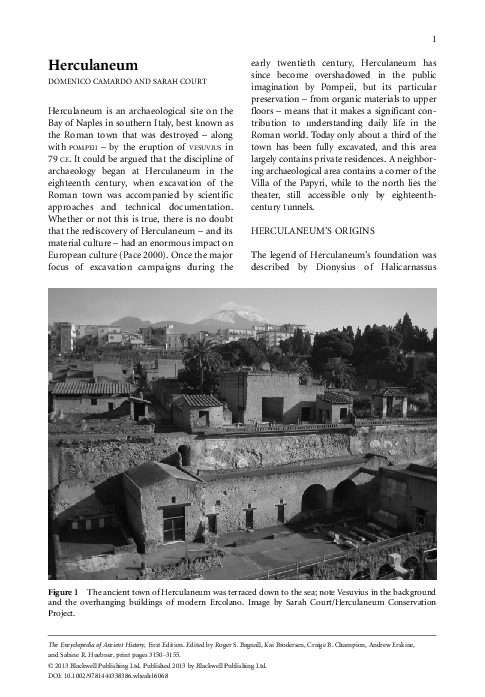
Figure 1 The ancient town of Herculaneum was terraced down to the sea; note Vesuvius in the background
and the overhanging buildings of modern Ercolano. Image by Sarah Court/Herculaneum Conservation
Project.
The Encyclopedia of Ancient History, First Edition. Edited by Roger S. Bagnall, Kai Brodersen, Craige B. Champion, Andrew Erskine,
and Sabine R. Huebner, print pages 3150–3155.
© 2013 Blackwell Publishing Ltd. Published 2013 by Blackwell Publishing Ltd.
DOI: 10.1002/9781444338386.wbeah16068
�2
(1.35): Hercules founded the town on his
return from Iberia while herding the Cattle of
Geryon along the Campanian coast; this legend reflects a Greek influence in the town’s
origins (see HERAKLES/HERCULES). Instead Strabo
(5.4.8) links Herculaneum to Pompeii, stating
that both settlements were first Oscan, then
Etruscan and Pelasgian, and later Samnite.
By the end of the fourth century BCE
Herculaneum must have been part of the socalled Nucerian league, together with Pompeii,
Stabiae, and Surrentum, communities that
Polybius includes in the Nucerian ethnos
(3.91.4). Along with these other settlements,
Herculaneum came under the Roman sphere
of influence in 308 BCE, the year in which
Nuceria was conquered in the Second Samnite
War. However, the town kept its OSCAN culture
and language alive for a long time, as seen in an
OSCAN inscription on a marble altar dedicated
to Venus Erycina by a magistrate in the Samnite period (Vetter 1953: 90 n. 107).
After rebelling against Rome during the
Social War, Herculaneum was re-conquered
in 89 BCE by Titus Didius, one of Sulla’s legates,
as recounted by Velleius Paterculus (2.16).
After the Roman conquest, Herculaneum had
the status of municipium and was run by two
annual magistrates known as duumviri. Inscriptions show that the town also had an aedile,
the magistrate who oversaw public maintenance and cleaning, and a quaestor who dealt
with the town finances.
URBAN LAYOUT
There is no secure archaeological evidence
to indicate when Herculaneum was founded.
The oldest part of the town presumably developed along the coastal road that ran from
Neapolis to Pompeii, which now lies 20 m
under the modern town of Ercolano. Excavations within the archaeological site have found
only a small amount of evidence dating to the
fourth century BCE, but it is not enough to
allow the town itself to be dated to that period.
Instead, enough remains of structures and
occupation levels have been found to be able
to date the early settlement to the turn of the
third/second century.
Herculaneum sits on a natural terrace
in a strategic position overlooking the sea.
This terrace was formed of accumulated tuff
layers from the Ottaviano/Mercato eruption
of Vesuvius (6000 BCE) and the ash layer
from the Avellino eruption (1750 BCE).
This had then been altered by human activity,
as the Ottaviano tuff was good quality for
construction, and quarrying lowered the area
by the sea by more than 10 m. The slope to the
sea was terraced, and the town was laid out
with three east–west decumani that followed
the natural curve of the land, and at least five
north–south cardines. Sisenna (fragment 53)
describes Herculaneum as an oppidum with
modest town walls and bounded by two seasonal river valleys running down from Vesuvius; it also had a harbor that was secure in all
seasons (fragment 54). The definition of an
oppidum gives the idea that the town was fortified; however, the two flanking river valleys
and the steep drop down to the sea made
strong defensive walls necessary only on the
northeast. Large opus quadratum blocks have
been found reused in various buildings across
the site, suggesting that an older town wall had
been built using that technique. Once the pax
Romana arrived in Campania, there was no
longer a need for defenses and this is reflected
in the construction of private homes up
against and outside the walls.
The archaeological site includes about half
of the ancient town up to the decumanus
maximus. Information from the eighteenthcentury tunnel excavations shows that there
was an upper decumanus paved in basalt that
can be identified as the Neapolis–Pompeii road
that passed through Herculaneum.
The Roman town as it existed at the time
of the eruption was the product of significant
reorganization and reconstruction in the early
imperial period, when most of the domus
were rebuilt and the richer seafront houses in
�3
particular expanded to encompass several
other properties. This phenomenon also
affected the few public buildings that have
been excavated so far – although the forum,
among other areas, is still buried.
Private property came in a wide range of
typologies (see HOUSES, HOUSING, HOUSEHOLD FORMATION, GREECE AND ROME). Large houses overlooking the sea combined the traditional
spaces of the Roman domus with a series of
panoramic residential rooms with terraces,
verandas, and belvederes (Pesando and
Guidobaldi 2006). Then there are houses of
the town’s “middle class,” often laid out as
standard atrium houses, but several examples
went beyond this, providing new solutions
for the atrium and the layout of spaces.
There are also large multistory buildings
divided into more modest apartments.
As for known public buildings, there
are three bath complexes; a building believed
to have been used by the AUGUSTALES; the partially excavated Basilica Noniana; the cult
building known as the Augusteum, which was
explored by tunnel although it remains
unexcavated; the large palaestra; and the theater, though again this has not been excavated
and can be visited only by tunnel. Instead,
the so-called Sacred Area on the sea front
has been completely excavated and seems to
have been a sanctuary dedicated to Venus.
A stuccoed podium found during eighteenthcentury excavations near the theater was
identified as another temple; it stands on the
decumanus maximus and is still partially
visible in a tunnel. Written sources provide
further information: inscriptions mention
a market (macellum), public weights and measures (pondera), a semicircular bench (schola),
and a monumental vestibule (chalcidium).
Another inscription mentions a temple to
Magna Mater, while sculptural fragments and
other archaeological finds suggest the existence
of a temple dedicated to Isis. As in all Roman
cities, there must have been a temple dedicated
to the Capitoline triad, and Herculaneum
must have had a temple dedicated to Hercules,
but as a large part of the town – including the
forum – has not been excavated, there is still
much to learn.
THE 79 CE ERUPTION
The town was profoundly damaged by the 62 CE
earthquake, which destroyed many private
homes and even damaged the public buildings.
The emperor Vespasian financed the restoration of the Augusteum and the Temple of
Magna Mater, while a local figure, Vibidia
Saturnina, and her son A. Furius Saturninus
paid for the reconstruction of Temple B in
the Sacred Area. While the town sought to
recover from that first earthquake, it was damaged again by further seismic shocks that hit
between 62 and 79, which were indications
of the imminent eruption. This final tragedy
has traditionally been dated to 24 August,
although some scholars have begun to question this date and suggest it was more likely
to have occurred between September and
October 79 (Stefani 2006).
Interdisciplinary studies in recent years have
allowed a detailed reconstruction of the final
period of Herculaneum’s life (Cinque and
Irollo 2008). Seismic shocks and bradyseism
seem to have led to great instability, and the
latter caused a lowering of the ground level and
consequently the sea encroached on the town.
This phenomenon caused damage to the buildings along the shoreline, including marine erosion, leading the owners to abandon ground
floors and to construct protective works against
the incoming sea. It is in this context that the
sudden explosion of VESUVIUS took place: as the
volcano was covered in vineyards and woods,
the local inhabitants had believed it to be
extinct.
After the initial explosion, a 15 km high
column of pyroclastic material was blown
towards Pompeii and Stabiae, where ashes
and lapilli rained down until the settlements
were covered by several meters of volcanic
material (see POMPEII, DESTRUCTION OF).
�4
Herculaneum seemed spared from the
volcano’s violence in this phase, and only a
very thin layer of ashes and lapilli fell on the
town. It was only on the second day of the
eruption, when the volcanic column collapsed,
that the town was hit by a burning cloud of gas
at more than 400� C that traveled at more than
80 km an hour (De Carolis and Patricelli 2003).
When this reached Herculaneum it instantly
destroyed all forms of life. The few inhabitants
who were still in the town were killed by thermal
shock, as were the more than 300 people whose
skeletons were found in the arches along the
shoreline and on the beach, where they were
perhaps waiting for help from the sea. In the
following hours a series of pyroclastic surges
and flows buried the town under 15–25 m of
volcanic material. This gradually solidified,
enclosing the structures and taking on a consistency that in some cases is as hard as tuff rock.
THE REDISCOVERY OF THE TOWN
AND EARLY EXCAVATIONS
The first news of ancient Herculaneum’s exact
location under the modern settlement of
Resina dates to the sixteenth century, when
Fabio Giordano reported on marbles and the
remains of ancient structures discovered during the digging of a well and in the foundations
of various buildings. In the seventeenth century too there were occasional finds, and the
identification of ancient Herculaneum was
confirmed by Giulio Cesare Capaccio and
Carlo Celano. However, it was not until 1710
that the Roman town was brought back to
wider public attention when the French prince
d’Elboeuf built his villa at nearby Granatello di
Portici and was offered ancient marbles found
by a farmer during the digging of a well. The
prince dug for nine months and brought up a
large quantity of marble and various statues, as
the well had come down onto Herculaneum’s
theater.
Systematic investigations started only in
1738 under King Charles of Bourbon. Tunnels
were employed for explorations using mining
techniques to overcome the thick compact
layer of solidified volcanic material. There
were enormous difficulties relating to the narrowness of the tunnels, the risk of cave-ins, the
lack of oxygen, and the presence of pockets of
poisonous gases.
The finds were taken to the royal palace at
Portici, where a proper museum was built in
1751, although access was restricted to the
king and the few visitors that he permitted to
admire his collections. The museum grew on
a daily basis with finds from Pompeii, Herculaneum, and Stabiae, and its fame spread rapidly across Europe (Cantilena and Porzio
2008). In 1750 the Villa of the Papyri was
discovered by chance, along with its rich sculptural decoration (Guidobaldi 2008) and over a
thousand carbonized papyri (Sider 2002),
increasing interest in the excavations at Herculaneum. However, the difficulty of the works
led to their gradually slowing down and then
ending definitively in 1780 in favor of Pompeii,
where excavation was easier and cheaper
(Parslow 1995).
Work resumed in 1828, and this time
open-air excavation was attempted for the
first time. This resulted in the excavation of
the House of Argus, which generated interest
for its upper-floor balcony overlooking the
street (which later had to be demolished as it
started collapsing). However, few finds were
discovered, and the work remained challenging
and came to an end in 1855. Excavations
started again only after the unification of
Italy, when in 1869 another small piece of
land was bought and the works, overseen by
the superintendent Giuseppe Fiorelli, were
inaugurated by King Victor Emmanuel II.
This small work site was exhausted by 1875
and excavation stopped.
THE MAIURI PERIOD
This state of affairs continued until 1924, when
Amedeo Maiuri became superintendent of the
excavations and antiquities of the Campania
region. Within a few years Maiuri had
�5
developed a plan for excavating and restoring
the ancient town, and new works officially
began on 16 May 1927. Maiuri put together
a team made up almost entirely of internal
superintendency staff who carried out all
phases of work from excavation to restoration
to the in situ display of the most important
finds. Herculaneum gradually became a sort of
open-air museum as the finds were contextualized, with a particular emphasis on objects
that illustrated daily life (Camardo 2006).
This excavation campaign was the most significant at Herculaneum and involved removing
more than 250,000 m3 of solidified volcanic
material. Most of the work took place between
1927 and 1942, when World War II almost
brought the excavations to a halt.
Since Maiuri’s retirement in 1961 his sitewide museum has gradually been dismantled
as objects are taken to storerooms and display
cases removed. This is because of damage
caused by temperature variations and atmospheric agents, the continual need to maintain
the display cases, and the increased risk of theft
linked to the development of mass tourism.
LATE TWENTIETH- AND EARLY
TWENTY-FIRST-CENTURY WORK
AT THE SITE
In the 1980s work focused on the ancient
shoreline to the south of the town, with the
excavation of the beach and a well-preserved
boat. In the arches facing on to the beach more
than 300 skeletons were found. In 1986 a project was started to identify the exact location
and layout of the Villa of the Papyri; the atrium
area was then excavated between 1993 and
1997. In the meantime, the regular program
of maintenance that Maiuri had set up for the
main archaeological site broke down, leading
to increasing decay of the ancient structures,
with the continual danger of collapse. Consequently about a third of the Roman houses and
streets were closed to the public.
In 2001 the Herculaneum Conservation
Project was set up by the Packard Humanities
Institute in partnership with the Soprintendenza Speciale per i Beni Archeologici di
Napoli e Pompei and the British School at
Rome. The project has become Italy’s largest
public–private partnership for heritage. Since
2004 the project has worked in partnership
with the superintendency across the site to
reduce decay and return Herculaneum to a
manageable state (Thompson 2007). The project team is working to establish a program for
the site’s long-term continual care, but also to
promote greater knowledge of and discussion
about Herculaneum among the international
and local communities, in order to ensure that
there is shared commitment to its future
protection.
SEE ALSO: Cities, Roman Empire (west);
Domus; Italy, southern; Municipia, Roman
Republic; Neapolis (Naples); Papyrus;
Pompeii; Volcanoes.
REFERENCES AND SUGGESTED READINGS
Camardo, D. (2006) “Gli scavi ed i restauri di
Amedeo Maiuri: Ercolano e l’esperimento di una
città museo.” Ocnus 14: 69–81.
Cantilena, R. and Porzio, A., eds. (2008)
Herculanense Museum: laboratorio sull’antico
nella Reggia di Portici. Naples.
Cinque, A. and Irollo, G. (2008) “La
paleogeografia dell’antica Herculaneum e le
fluttuazioni, di origine bradisismica, della
sua linea di costa.” In P. G. Guzzo and
M. P. Guidobaldi, eds., Nuove ricerche
archeologiche nell’area Vesuviana
(scavi 2003–2006): 425–38.
Rome.
De Carolis, E. and Patricelli, G. (2003) Vesuvius AD
79: the destruction of Pompeii and Herculaneum.
Los Angeles.
Guidobaldi, M. P., ed. (2008) Ercolano: tre secoli di
scoperte. Naples.
Pace, S. (2000) Herculaneum and European culture
between the eighteenth and nineteenth centuries.
Naples.
Pagano, M., ed. (2000) Gli antichi ercolanesi:
antropologia, società, economia.
Naples.
�6
Parslow, C. C. (1995) Rediscovering antiquity: Karl
Weber and the excavation of Herculaneum,
Pompeii and Stabiae. Cambridge.
Pesando, F. and Guidobaldi, M. P. (2006) Gli ozi di
Ercole: residenze di lusso a Pompei ed Ercolano.
Rome.
Sider, D. (2002) The library of the Villa of the
Papyri at Herculaneum. Los Angeles.
Stefani, G. (2006) “La vera data dell’eruzione.”
Archeo 260: 10–14.
Thompson, J. (2007) “Conservation and
management challenges in a public/private
partnership for a large archaeological site
(Herculaneum, Italy).” Conservation and
Management of Archaeological Sites 8,
4: 191–204.
Vetter, E. (1953) Handbuch der italischen Dialekte,
vol. 1: Texte mit Erklärung, Glossen,
Wörterverzeichnis. Heidelberg.
�
 Sarah Court