Academia.edu no longer supports Internet Explorer.
To browse Academia.edu and the wider internet faster and more securely, please take a few seconds to upgrade your browser.
2018, Student Centered Research in the Applied Anthropology Laboratories 2014-2018
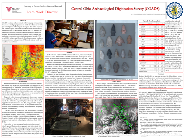
COADS is a large-scale, systematic effort to engage private collections in one small geographic area to enrich the official record of the pre-contact period archaeology in the region. This initial 2-year effort is funded by the National Science Foundation and has already documented over 14,000 artifacts and 300 sites. All materials are documented digitally (2D images) with a random 5% sample 3D scanned. We summarize methods, progress, public response, and a preliminary comparison to previously documented records. With over 10,000 artifacts and 80 sites in Ross County, we can conduct a coarse comparison to the previous OAI records and our newly recorded sites and materials.
Current Research in Ohio Archaeology
Central Ohio Archaeological Digitization Survey: Preliminary Report2021 •
The Central Ohio Archaeological Digitization Survey (COADS) is a collaborative research project between Ball State University, the University of Akron, and over a dozen private collectors from Ohio to Colorado funded by the National Science Foundation (BCS #1723879 and BCS #1723877). COADS' three primary goals are to 1) investigate patterns of land use and technology over long expanses of past time in central Ohio (see Nolan 2014), and 2) to leverage the large, if selective, datasets of private collectors for analytical purposes (characterizing point types using geometric morphometrics methods and modeling the transitions between types). Finally, COADS is also designed to serve as a model of productive collaboration between archaeologists and responsible collectors that, among other things, will greatly increase relevant sample sizes (Pitblado and Shott 2015; Shott 2008; 2015). The goal of this paper is to summarize the initial results of collaboration with local collectors, who own the majority of projectile points across the Midwest (Shott 2017), and general patterns interpreted from one of the largest amassed projectile point databases in the world.
Current Research in Ohio Archaeology
No Shovel Required: An Archaeological Inventory of Greater Akron, Ohio2017 •
In the fall of 2016, an inventory was conducted of the University of Akron's (UA) previous archaeological field work and research. The goal of this inventory project was to identify and submit previously unreported archaeological survey reports and archaeological sites to the Ohio Archaeological Inventory (OAI) and the National Archaeology Database (NADB). The OAI form is a ten page form containing a plethora of information about a specific archaeological site beginning with UTM coordinate location to narrative descriptions of artifact patterning. Two sections of the OAI, I.1 and I.2, describe the site in a narrative form and the relationship of the site to other archaeological sites in the region. During the process of completing the sections I.1 and I.2, I conducted basic background research of the known archaeological sites within approximately one mile to each site. While conducting background research, I observed other archaeological sites not yet reported in the OAI including, in part, the OAI forms I was completing for past University of Akron (UA) projects. Many of the backlogged UA sites were a mix of surveys never formally published or submitted to the OHPO, dating as early as the late 1970s up to the present.
Reports of Investigation
An Archaeological Survey of Newton County: Enhancement of a Data Deficient Region, Part III Grant # 18-16FFY-042017 •
The Applied Anthropology Laboratories (AAL) at Ball State University conducted a data enhancement project for archaeological resources in Newton County, Indiana for a FY2016 Historic Preservation Fund Grant (Grant #18-16FFY-04). This Historic Preservation Fund grant project investigated the archaeological resources of Newton County, Indiana with a focus on the two central townships, Beaver and Jackson, and under-represented ecological communities within Newton County based on FY2014 and FY2015 surveys. A total of 932.27 acres (377.27 hectares) of agricultural land were surveyed, which includes 5.63 acres of resurveyed area, and 110 new archaeological sites were recorded. The survey recovered 103 prehistoric artifacts and 4,063 historic artifacts from nine parcels of land within Newton County. No human remains were discovered as a result of this grant project. Cultural periods that are represented in the artifact assemblage include precontact era Middle Archaic, Middle-Late Archaic, Late Archaic, and Late Woodland components, in addition to Historic components. The average site density recorded for the project area for precontact sites was one site per 24.53 acres and for Historic sites was one site per 10.02 acres.
Reports of Investigation
An Archaeological Survey of Newton County: Enhancement of a Data Deficient Region, Part II Grant # 18-15FFY-052016 •
The Applied Anthropology Laboratories (AAL) at Ball State University conducted a data enhancement project for archaeological resources in Newton County, Indiana for a FY2015 Historic Preservation Fund Grant (Grant #18-15FFY-05). This Historic Preservation Fund grant project investigated the archaeological resources of Newton County, Indiana with a focus on the Kankakee River, Beaver Lake, and the northern half of the county. Approximately 856.1 acres (346.45 hectares) of agricultural land were surveyed, which includes 7.1 acres of resurveyed area, and 76 new archaeological sites were recorded. The survey recovered 525 prehistoric artifacts and 1,761 historic artifacts from nine parcels of land within Newton County. No human remains were discovered as a result of this grant project. Cultural periods that are represented in the artifact assemblage include Early Archaic, Late Archaic, Late Archaic/Early Woodland, Late Woodland/Late Prehistoric, and Late Prehistoric components that were documented from the precontact era, in addition to Historic components. The average site density recorded for the project area for precontact sites was one site per 42.45 acres and for Historic sites was one site per 13.69 acres.
Reports of Investigation
An Archaeological Survey of Benton County: Enhancement of a Data Deficient Region, Part II Grant # 18-16FFY-032017 •
The Applied Anthropology Laboratories (AAL) at Ball State University conducted a data enhancement project for archaeological resources in Benton County, Indiana for a FY2016 Historic Preservation Fund Grant (Grant #18-16FFY-03). This Historic Preservation Fund grant project investigated the archaeological resources of Benton County, Indiana with a focus on the southern half of the county. A total of 928.36 acres (375.69 hectares) of agricultural land was surveyed and 115 new archaeological sites were recorded. The survey recovered 102 prehistoric artifacts and 2161 historic artifacts from 13 parcels of land within Benton County. No human remains were discovered as a result of this grant project. Cultural periods that are represented in the artifact assemblage include precontact components dating to the Late Archaic, Middle Woodland, and possibly the Early Archaic, in addition to Historic components. The average site density recorded for the project area for precontact sites was one site per 14.07 acres and for historic sites was one site per 13.65 acres.
Reports of Investigation
An Archaeological Survey of Newton County: Enhancement of a Data Deficient Region Grant # 18-14-FFY-032015 •
The Applied Anthropology Laboratories (AAL) at Ball State University conducted a data enhancement project for archaeological resources in Newton County, Indiana for a FY2014 Historic Preservation Fund Grant (Grant #18-14-FFY-03). This Historic Preservation Fund grant project investigated the archaeological resources of Newton County, Indiana with a focus on the Iroquois and Kankakee Rivers and the southern half of the county. Approximately 902.84 acres (365.33 hectares) of agricultural land were surveyed and 89 new archaeological sites were recorded. The survey recovered 55 prehistoric artifacts and 1274 historic artifacts from eight parcels of land within Newton County. No human remains were discovered as a result of this grant project. Cultural periods that are represented in the artifact assemblage include Late Archaic components that were documented from the precontact era, in addition to Historic components. The average site density recorded for the project area for precontact sites was one site per 36.11 acres and for Historic sites was one site per 12.20 acres.
Reports of Investigation
An Archaeological Survey of Benton County: Enhancement of a Data Deficient Region Grant # 18-15FFY-032016 •
The Applied Anthropology Laboratories (AAL) at Ball State University conducted a data enhancement project for archaeological resources in Benton County, Indiana for a FY2015 Historic Preservation Fund Grant (Grant #18-15FFY-03). This Historic Preservation Fund grant project investigated the archaeological resources of Benton County, Indiana with a focus on the northern half of the county. Approximately 841.29 acres (340.46 hectares) of agricultural land were surveyed and 85 new archaeological sites were recorded. The survey recovered 81 prehistoric artifacts and 442 historic artifacts from twelve parcels of land within Benton County. No human remains were discovered as a result of this grant project. Cultural periods that are represented in the artifact assemblage include precontact components dating to the Late Archaic, Middle Woodland, and possibly the Early Archaic, in addition to 54 Historic components. The average site density recorded for the project area for precontact sites was one site per 20.03 acres and for historic sites was one site per 15.58 acres.
Indiana Archaeology
A Data Deficient Region: An Archaeological Survey of Newton County, IndianaThe Applied Anthropology Laboratories (AAL) at Ball State University conducted a data enhancement project for archaeological resources in Newton County, Indiana for a FY2014 Historic Preservation Fund Grant (Grant #18-14-FFY-03). This Historic Preservation Fund grant project investigated the archaeological resources of Newton County, Indiana with a focus on the Iroquois and Kankakee Rivers and the southern half of the county (Beaver, Grant, Jackson, Jefferson, Iroquois, and Washington townships). Approximately 902.84 acres (365.33 hectares) of agricultural land were surveyed, and 89 new archaeological sites were recorded. The survey recovered 55 prehistoric artifacts and 1274 historic artifacts from eight parcels of land within Newton County. No human remains were discovered as a result of this grant project. Cultural periods that are represented in the artifact assemblage include Late Archaic components that were documented from the precontact era, in addition to historic components. The average site density recorded for the project area for precontact sites was one site per 36.11 acres and for Historic was one site per 12.20 acres. This article will concentrate on the prehistoric results of this project.
Reports of Investigation
An Archaeological Survey of Jasper County: Enhancement of a Data Deficient Region Grant # 18-14-FFY-02The Applied Anthropology Laboratories (AAL) at Ball State University conducted a data enhancement project for archaeological resources in Jasper County, Indiana for a FY2014 Historic Preservation Fund Grant (Grant #18-14-FFY-02). This Historic Preservation Fund grant project investigated the archaeological resources of Jasper County, Indiana with a focus on major waterways such as the Iroquois and Kankakee Rivers in the southern half of the county. Approximately 900 acres (364.22 hectares) of agricultural land were surveyed and 112 new archaeological sites were recorded. The survey recovered 209 prehistoric artifacts and 307 historic artifacts from seven parcels of land within Jasper County. No human remains were discovered as a result of this grant project. Cultural periods that are represented in the artifact assemblage include Middle Archaic, Late Archaic, and Late Woodland/Late Prehistoric components that were documented from the precontact era, in addition to Historic components. The average site density recorded for the project area for precontact sites was one site per 15 acres and for Historic sites was one site per 13.85 acres.
Editura Științifică, București, 1974
Strabon, Geografia, vol. II [tr. Felicia Vanț-Ștef] [1974]International Business & Economics Studies
Financial Reporting for Small and Medium-Sized Enterprises (SMES) In Nigeria: A Review of Literature2024 •
Building and Environment
Analysis of user's characteristics of three different playgrounds in districts with different socio-economical conditions2007 •
2017 •
Geology
Southern Louisiana salt dome xenoliths: First glimpse of Jurassic (ca. 160 Ma) Gulf of Mexico crust2011 •
Berichte über Landwirtschaft - Zeitschrift für Agrarpolitik und Landwirtschaft
Anwendung von organischen Düngern und organischen Reststoffen in der Landwirtschaft2016 •
Nigerian Journal of Clinical Practice
Classification and management challenges of otitis media in a resource-poor country2011 •
Molecular Psychiatry
Generation of functional human serotonergic neurons from fibroblasts2015 •
 Michael Shott
 Kevin C. Nolan
 Eric C Olson