Preliminary Study of Urban Heat Island: Measurement of Ambient Temperature and Relative Humidity in Relation to Landcover in Kuala Lumpur
Illyani Ibrahim1*, Azizan Abu Samah1
1Department of Geography, Faculty of Art and Social Science,
University of Malaya, Malaysia
*Corresponding author, e-mail: illyani254@gmail.com
Abstract—Urbanization creates a landscape modification that leads to urban heat island; this problem is worsening in Kuala Lumpur areas with a large number of population, extensive economic activities with a wide range of factories and transportation, and a modern lifestyle; air conditioner uses, due to the heat generated. This preliminary study examined the correlation of ambient temperature and relative humidity and its relationship to landcover types. The appropriate approach of conducting in situ measurement should be identified before carrying out future study in order to avoid bias. A mobile survey with a temperature data logger with GPS and the processing of remote sensing images for the identification of landcover are applied. Qualitative and quantitative analysis indicates that the landcover conditions will influence the urban temperature that indirectly contributed to the occurrence of urban heat island.
Keywords-ambient temperature; landcover; urbanization; heat
Introduction
Supported by the Ministry of Higher Education, Malaysia (MOHE) and Institute of Research Management and Consultancy (IPPP) grant, University of Malaya, Malaysia (PS433/2010B)
In recent decades, scientists have been aware that land use and land cover change triggered by human activities can give a great impact to the high temperatures in urban areas that can modify the energy balance in cities. Density of buildings, energy consumption of households, construction and transportation has made the heat trapped even worse. Numerous studies have shown that urbanization has created a significant difference by modifying the local climate of temperature, precipitation and cloudiness [1-3]. This type of knowledge is important in issues such as urban climatology, global environmental change and the interaction between humans and environment.
The air and surface changes due to urbanization creates alteration of thermal environment that is warmer in urban area compared to rural area; this phenomenon is known as urban heat island (UHI). With an indication of urbanization with almost 60% of world population living in the city, urban heat islands (UHI) can give rise to a variety of environmental, social and economic problems. In fact, urban population has increased from 160 million to about 3 billion in just 100 years, and it is expected to increase to about 5 billion by 2025 [4].
In urban areas, the existence of construction materials would decrease the evapotranspiration rate due to waterproofing surfaces, resulting in increased surface run-off and consequently lower infiltration [5]. The waterproofing involves a hydrologic effect and indirectly leads to climatic issues. The measurement in cities is difficult because of the complex structure of the urban atmosphere interface [6], which is due to the urban climate’s combination of different factors at different scale. According to Daily Yomiuri, the government of Japan has made efforts to reduce the urban heat island phenomenon by investing 800 million yen in order to plant trees on the rooftops and around the entrances of buildings [7].
This preliminary study examined the correlation of ambient temperature and relative humidity with its relationship to landcover types. This research is also important to understand how to minimize bias as a preparation for future study which will be conducted in a bigger study area. Therefore, mobile surveys are carried out for 3-day periods from 10 a.m. to 2 p.m. Objectives of this study are as follows: (i) to analyse the ambient temperature distribution in the area of Kuala Lumpur in relation to landcover; (ii) to analyze the correlation of ambient temperature to relative humidity; and (iii) to identify appropriate approach in preparation to conduct another in situ measurement in a bigger area.
This paper is organized as follows: Section 2 presents the study area. Section 3 introduces the data and proposed method. Section 4 presents the results and Section 5 gives the discussion of results. Section 6 concludes the paper.
Study area
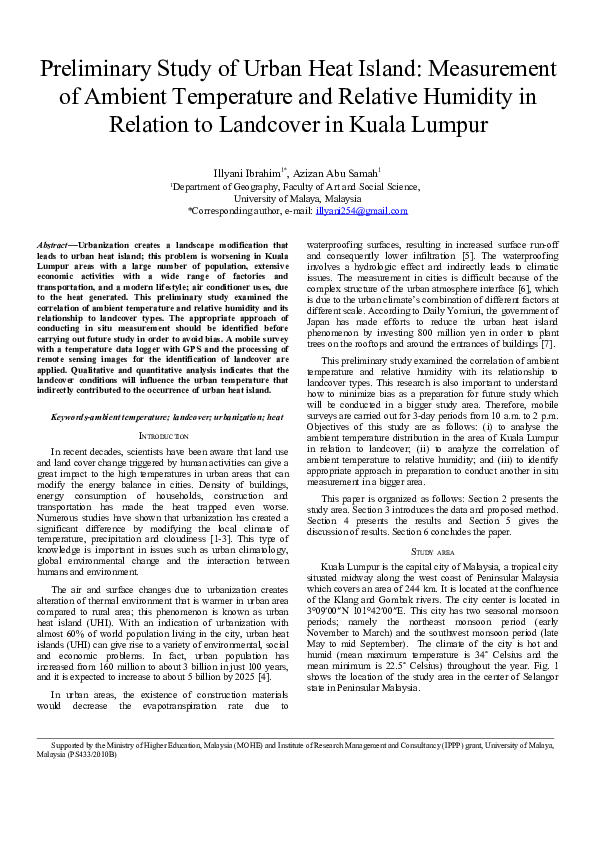
Kuala Lumpur is the capital city of Malaysia, a tropical city situated midway along the west coast of Peninsular Malaysia which covers an area of 244 km. It is located at the confluence of the Klang and Gombak rivers. The city center is located in 3°09′00″N 101°42′00″E. This city has two seasonal monsoon periods; namely the northeast monsoon period (early November to March) and the southwest monsoon period (late May to mid September). The climate of the city is hot and humid (mean maximum temperature is 34˚ Celsius and the mean minimum is 22.5˚ Celsius) throughout the year. Fig. 1 shows the location of the study area in the center of Selangor state in Peninsular Malaysia.
Peninsular
Malaysia
Study area show Peninsular Malaysia (inset), Selangor (below) and part of 5 x 5 km2 in Kuala Lumpur area
Extensive land development in urban areas has completely altered the surface profile of the cities [8]. This city grows as the fastest metropolitan area in Asia and faces serious environmental problem of urban heat island, traffic congestion, air pollution from industrial and vehicular emissions and flash floods due to its rapid urbanization and development.
Today, some 50 percent of the world’s population lives in urban areas [9]. Being a capital city of Malaysia, Kuala Lumpur has an expanding urban population due to increasing number of migrants searching for better working opportunities. The size of the city will increase as it accommodates the increasing population. At the same time, Kuala Lumpur and its conurbation form a region that is the most industrialised and economically the fastest growing in the country which will lead to structured low and high rise buildings of apartments and offices; thus this scenario indirectly will replace the natural landscape by concrete.
Data and Methodology
To analyze the ambient temperature and humidity in the study area, the in situ measurement was carried out by using mobile measurement with Hygromaster Protimeter 7700 and GPS tool. The measurements accuracy is ±0.1˚C and ±1% for temperature and relative humidity, respectively. The secondary dataset is the urban land use data gathered from the DBKL (Kuala Lumpur City Hall). The Landsat image processing was used for the analysis of landcover classes by using Erdas Imagine software package. The landcover map was used to be overlaid with in situ measurement datasets stored in the database.
In situ Measurement
In order to measure the spatial variability of the northeast season (rainy season) of temperature experienced across the Kuala Lumpur area, mobile measurements were undertaken using a vehicle mounted with the temperature sensor that allows quantitative measurement of the canopy layer; the measured parameters are air temperature and relative humidity. The measurement period will be referred to the weather forecast to ensure that the measurement is demonstrated under less cloudy sky condition, no rain and light winds. It is very rare to have a clear sky in a tropical country like Malaysia, therefore less cloudy is acceptable in this research.
Data were collected by driving along the roads with a temperature electronic data logger attached to the temperature probe. These data were assigned with a same unique ID so it could be paired with a GPS location and altitude. All these parameters are then able to be logged and it was downloaded to be matched with the GPS datasets. Approximately 5 x 5 km square of Kuala Lumpur areas were covered which consisted of 75 locations. The measurement covered the constituencies of the study area; Bukit Bintang, Kuala Lumpur City Centre (KLCC), Masjid India, Tasik Perdana, Pudu and Parliament area. The various temperature points will vary according to time, between 10 am to 2 pm daytime with approximate same time in each day.
The datasets were transferred to ArcGIS software for interpolation analysis where kriging was used to see how the pattern of temperatures varies. The geostatistical analysis so called kriging whereby its semiviogram model used was Exponential environment was carried out to predict unknown values from data observed at known location. The contour map of 1˚ Celsius was created and overlaid to the landcover types for the analysis of the temperature boundary over measurements.
Preparation of Image Data
The Landsat satellite data was downloaded from the USGS under 10% of cloud with WGS 84 UTM Projection. The image was radiometric and geometrically corrected with operation of subset procedure as the process of “cropping” or cutting out a portion of an image.
The area of interest (AOI) tool was used as a training sample to categorise landcover. Based on knowledge of the study area and the guidance of Google Earth, 10 training areas were carefully defined. The supervised classification is carried out by selecting the saved training sample with the selection of parametric rule of maximum likelihood. The buildings, roads and pavement areas have been merged to urban areas in order to perform the correlation analysis. This need to be stressed in order to see how these land cover and the ambient temperature and humidity are related to each other.
The raster data of landcover then was converted to vector to be a gridded vector data. This is crucial to analyze the correlation with each group of measurements. The identity spatial analysis was carried out to overlay the temperature boundary and landcover. According to temperature contour, the areas of each landcover type were calculated and the correlation among variables was identified.
Result
In order to identify the existence of correlation between the ambient temperature and relative humidity, 3-day periods of in situ measurement were carried out. To fulfil this analysis, both variables were plotted with a sample size of 75 readings in each group of measurements. By referring to Table I, this comparative study shows that there is significantly negative correlation existing between ambient temperature and relative humidity.
Correlation of Ambient Temperature (˚C) and Relative Humidity (RH %)
Date
Intercept
Slope
R²
20th Jan 2011
-3.267
155.0
.764
24th Jan 2011
-2.917
139.4
.710
27th Feb 2011
-4.602
193.9
.719
The variability in the relative humidity during the latter period was much lesser compared to the earlier measurement. From descriptive statistics given in Table II, it can be seen that the average of humidity was a bit varied; 20th Jan having 49.34 of relative humidity, 24th Jan and 27th Feb 44.54 and 39.0, respectively which presumably was due to unexpected frequency of precipitation. On the other hand, the average ambient temperature was consistent (approximately 33˚ Celsius) for these measurement dates.
It can be seen that the decreases of humidity and its percentages were consistent with the temperature increase in the study area. In the other word, higher temperature will reduce the relative humidity.
Descriptive Statistics of Ambient Temperature (˚C) and Relative Humidity (RH %) during in Situ Measurement for 3-day Periods
Date
Ta (˚C)
RH (%)
20th Jan 2011
Average
33
49.3
Std deviation
2.1
8.1
24th Jan 2011
Average
33.4
44.5
Std deviation
2.1
7.6
27th Feb 2011
Average
33.2
39.0
Std deviation
1.4
7.1
To conduct analysis of landcover and ambient temperature, a set of landcover area of percentage classes are designed within the study area. This analysis shows that ambient temperature was lower in the green areas at the western part and higher at the center. Results show that there is correlation of both variables; where positive correlation exists with urban and negative correlation with green areas where the range of correlation is almost the same for the groups of measurements. (Table III). It was found that the higher the ambient temperature, the higher percentage of urban and the lesser the percentage of green area. On the other hand, there is no correlation of ambient temperature with water body. This might be because the heat capacity of the water body is greater than that of the land so it needs more energy to heat it up compared to the same amount of land and it takes longer time. It also takes longer time to cool down especially during night time.
Correlation (r² values) Between Landcover Types and Temperature
Date
Features
Intercept
Slope
R²
20th Jan 2011
Urban
7.196
-149.9
.843
Green areas
-7.197
246.6
.805
Water body
-0.003
3.107
.005
24th Jan 2011
Urban
0.039
-0.456
.780
Green areas
-0.051
1.840
.788
Water body
-0.003
0.135
.344
27th Feb 2011
Urban
8.109
-193.6
.833
Green areas
-7.895
284.4
.816
Water body
-0.207
8.984
.041
Visual inspection of the overlay of temperature contour with landcover (left) and temperature kriging for the study area (Fig 2) indicate that the temperatures in the eastern and south urban; Bukit Bintang and Central Market respectively was a bit varied but seems to have high temperatures for these 3-day period measurements.
a (i) a (ii)
Figure 2. Landcover (left) and isotherms (right) of 20th Jan [a (i) and a (ii)], 24th Jan [b (i) and b (ii)], and 27th Feb [c (i) and c (ii)], respectively
The temperature at Menara Kuala Lumpur area is not as cool as expected but it still remains in appropriate condition. It was also found that the relative humidity of this area is also low even though this area was surrounded by the green areas and located next to Bukit Nanas (reserved forest). This apparent discrepancy might be due to this location that lies in between areas of high temperature. Coverage by the green features made this area at least 2˚ Celsius lower compared to its neighbour.
The highest ambient temperature, 37˚ Celsius, was found at Dataran Merdeka area while the lowest temperature was 26.7˚ Celsius at the Lake Garden (Taman Tasik Perdana) area. Greater relative humidity (71.2%) was found in the peripheries at the Lebuhraya Mahameru along Parliament area to the Lake Garden (Taman Tasik Perdana); these areas are surrounded by green features. The lowest humidity was found at Central Market area (33.5%) where this may be resulting from its compactness as an area of rapid population mobility; the bus station terminal, roads, and Light Rail Transit (LRT) station terminal are located less than 500 meters from the probe location. Approximately 20 meter width of Klang River that flow parallel to the roads apparently has no impact on the humidity reading.
It was noticeable that temperature changed continuously with a small scale in urban areas in the study area. The cooler temperature reading was found at the Jalan Tunku Abdul Rahman area, maybe because of the effect of the shadow of buildings and trees. The cooler temperature was also found in the Lake Garden (Taman Tasik Perdana) at the northwestern part of the study area where it can be identified as most of the landcover are green features.
Discussion
The highest temperature found in the three measurements were at Dataran Merdeka. This area showed unexpected highest measurement of ambient temperature; up to 37˚ Celsius (Fig. 2) for both 24 Jan and 27 Feb but on 20 Jan it was 35˚ Celsius. On 20th Jan, less transportation was used on the road that day because it was a holiday. The 27th Feb was also holiday but the high temperature may be due to the program conducted at Dataran Merdeka whereby more than 100,000 people attended. Lastly, during 24th Jan, the measurement was carried out during a working day and it may be a factor of increasing temperature due to heavy transportation. In addition, its location is situated next to the federal roads and surrounded by high buildings, which might obstruct the wind from any direction from moving to this area.
It was apparent that the pattern of relative humidity is reverse to the pattern of ambient temperature between the points collected. The result of Menara Kuala Lumpur is consistent with the research in Portland’s Forest Park [10]; Bukit Nanas as a small reserved forest plays an important role that gives a cooler influence to this area when factor such as shading from the dense canopy and evaporation are most important.
Findings by Sham had discussed the high temperature during the day time survey at Jalan Tunku Abdul Rahman, where a contradiction existed with this study that these areas were less warm compared to the other sites [11]. It is true that this area is crowded with people but another factor influencing factor may be the surrounding high buildings that give cooler temperature readings with the shadows of big trees and buildings.
For such result to be comparable of the heat analysis, the in situ measurement must be conducted under comparable condition. In this study, it is needed to measure the temperature during a hot dry environment with the avoidance of cloudy and rainy day. The big problem in planning the measurement is that the weather nowadays faces a lot of unpredicted heavy rains, thunderstorms and hot days. For example, as reported by the Meteorological Department, on 19th February 2011, there was supposed to be a thunderstorm in the study area, but it turned into a few cloudy skies with a hot and dry day environment.
There may be existence of overestimation bias received by the temperature probe used in this research which is not calibrated as the calibration needs to be done in the weather station. It should be understood that the reading collected by the weather station was been calibrated by the Stevenson Screen that is crucial in avoidance of direct sunlight. The limitation of in situ measurement is that the probe was interfered by the sun radiance so the readings may be not be accurate. In future, the same temporal datasets produced by the Meteorology Department should be collected to be used as a correction of the probe.
From the analysis of the temperature and relative humidity readings, some biases were identified. In future, some restriction of carried out measurement should be taken into account; (i) due to the climate condition, the measurement should be under no or less cloud, (ii) in situ measurement cannot be carried out under light or heavy rain to avoid bias and wind interference, (iii) readings cannot be taken in the middle of buildings that can give a biased temperature due to shade of the buildings and trees.
From overall temperatures, the maximum temperature difference between the highest and the lowest was 8˚ Celsius during daytime. It was extraordinary because the study area is only covering the urban area to understand the temperature behavior towards the same area in different time period, yet still did not include the rural area temperature measurement.
According to the analysis that was cover in this paper, the proposed suggestions are as below:
1. More green trees and water sprinkle should be taken into account. For example, the highest temperature at Dataran Merdeka area need to focus more in order to reduces its heat. This area has a historical value that needs to be environmentally preserved;
2. Add more green roofs and trees to ensure that the heat can be reduced. Appropriate green spaces also need to be considered. For example, it can be seen that concrete covers almost 90% of a landcover in the area of Central Market.
Conclusions
This study is to identify the pattern of temperature and humidity in Kuala Lumpur area by using in situ measurement and landcover analysis by using satellite image. From the analysis and results obtained in this study, it was concluded that there was a strong positive correlation of the ambient temperature and the landcover and negatively strong correlation of temperature and humidity. It was identified that the higher temperature boundary existed in the urbanization area that is compact with concrete features. The highest temperature was consistently seen at Dataran Merdeka for all measurements, but on 27th Feb, it was also high at Bukit Bintang. The lowest temperature was at the Lake Garden (Taman Tasik Perdana) for three measurements which indicate that the areas having very dense green would help to minimize temperature.
According to the statistics produced from Malaysian Meteorological Department (MET), the highest mean temperature was 34˚ Celsius in Subang meteorological station, approximately 12 km from the study area. In this study, the mean of the temperature is 33˚ Celsius which was less 1˚ Celsius compared to Subang. The result shows that there is consistency of both mean temperatures reading.
It was agreed that the influence of wind towards temperature distribution is important, but due to lack of wind instrument and budget limitation for wind data, wind speed was not recorded. In further studies, the wind speed factor will be covered in order to give a clearer picture of the study area. As this is a preliminary study of urban heat island, further research of land surface temperature and diurnal study by using remote sensing will be carried out for analysis assessment to confirm and identify the heat island occurrences in the study area.
Acknowledgment
Thanks to the assistance of personnel for helping in carry out in situ measurement. Special thanks also goes to USGS for supplying the Landsat image remote sensing data that was retrieved from USGS website: http://glovis.usgs.gov/
References
A. Nonomura, M. Kitahara, and T. Masuda, "Impact of land use and land cover changes on the ambient temperature in a middle scale city, Takamatsu, in Southwest Japan," Journal of Environmental Management, 2009. 90: p. 3297-3304.
D. A. Quattrochi and C. P. Lo, "Land-use and land-cover change, urban heat island phenomenon, and health implications: A Remote Sensing approach", Photogrammetric Engineering & Remote Sensing, 2003. 69(9): p. 1053-1063
L. Huang, D. Zhao, J. Wang, J. Zhu, and J. Li, "Scale impacts of land cover and vegetation corridors on urban thermal behavior in Nanjing, China," Theor. Appl. Climatol., 2008. 94: p. 241-257.
D. Kolokotsa, A. Psomas, and E. Karapidakis, "Urban heat island in southern Europe: The case study of Hania, Crete," Solar Energy, 2009. 83(10): p. 1871-1883.
C. T. Loong, "The temporal dynamics of the urban heat island of Singapore," 2004. National University of Singapore: Singapore. p. 196.
J. Voogt and T. Oke, "Complete urban surface temperatures," Journal of Applied Meteorology, 1997. 36(9): p. 1117-1132.
Daily Yumoiri (2008, 14 August). Tokyo station heat island targeted, Daily Yumoiri
E. Ahmad Fuad and M. D. Norlida, "Urban heat islands effects on the microclimate of Malaysian cities," n.y.
E. I. Che-Ani, P. Shahmohamadi, A. Sairi, M. F. I. Mohd-Nor, M. F. M Zain, and M. Surat, "Mitigating the Urban Heat Island Effect: Some points without altering existing city planning," European Journal of Scientific Research, 2009. 35(2): p. 204-216.
M. A. Hart and D. J. Sailor, "Quantifying the influence of land-use and surface characteristics on spatial variability in the urban heat island," Theor. Appl. Climatol., 2009. 95: p. 397-406.
S. Sham, The Climate of Kuala Lumpur – Petaling Jaya Area, A Study of the Impact of Urbanization on Local Climate Within the Humid Tropics, Malaysia:UKM Press, 1980.
Selangor
b (i) b (ii)
c (i) c (ii)
b) e) c) f)
 Illyani Ibrahim
 Azizan Samah