12
2021
ARCHAEOLOGY SECTION REPORT FOR 2021
TANYA WALLS (SECTION SECRETARY)
PHILIP DE JERSEY (STATES ARCHAEOLOGIST)
ANDREW LANE (ASSISTANT ARCHAEOLOGIST)
The pandemic made for another unusual year, although in Guernsey
archaeology was affected less than in many areas. The Section was involved
in two main projects: at the beginning of the year industrial buildings were
discovered at the Vale Mill Quarry, and later in the year there was an excavation
in the garden of the ‘Shell House’ at Le Villocq. Digging in Sark was not possible
this year, but we did manage a small project at The Nunnery in Alderney. All of
this fieldwork is described below.
In addition to working on excavations, the Section met regularly for
field trips and finds processing. Most months we led an activity for the Junior
Section which had been revived at the start of the year by the Education Team.
In June we led two guided trips to Jethou and in October accompanied Nature
Guernsey to La Chapelle Dom Hue. In July the Section assisted La Mare de
Carteret School with a ‘Time Team style’ three-day archaeology event on the
school playing fields. Professor Carenza Lewis of Lincoln University came over
to assist with this project and kindly gave La Société a very topical lecture
entitled Pits, Pots and Pandemics - digging the Black Death in your garden.
Visits to coastal sites
Field trips began in April with a visit to Herm to look at two possible
megalithic sites in the inter-tidal zone and to monitor eroding sites in the dunes.
We chose a day with a low spring tide (0.5m) to give ourselves the best chance
of reaching the inter-tidal sites; these had both been reported by members of
the public (and in one case, much longer ago – see below) and we took along
photographs taken at different times over the last ten or fifteen years from which
to identify them. Prehistoric monuments are well known from inter-tidal locations
in Brittany and two such sites have been investigated at Rousse (Guernsey)
by the Clifton Antiquarian Society (Transactions 2016). Such monuments were
originally on the coast but have ended up on the beach due to sea-level rise.
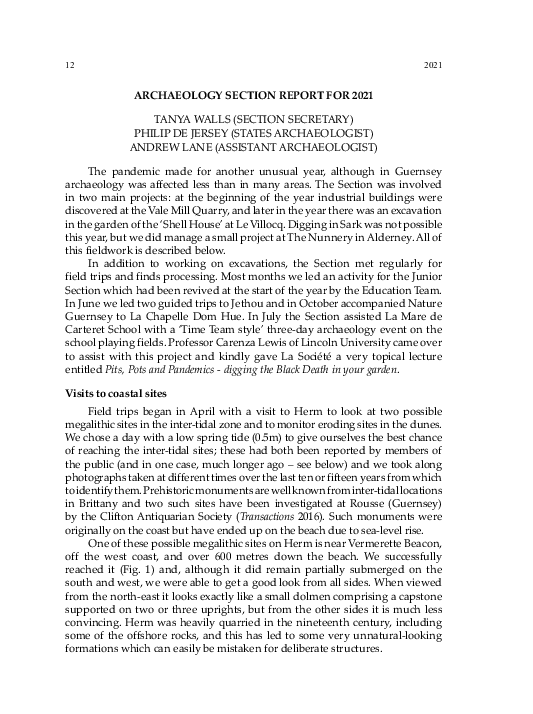
One of these possible megalithic sites on Herm is near Vermerette Beacon,
off the west coast, and over 600 metres down the beach. We successfully
reached it (Fig. 1) and, although it did remain partially submerged on the
south and west, we were able to get a good look from all sides. When viewed
from the north-east it looks exactly like a small dolmen comprising a capstone
supported on two or three uprights, but from the other sides it is much less
convincing. Herm was heavily quarried in the nineteenth century, including
some of the offshore rocks, and this has led to some very unnatural-looking
formations which can easily be mistaken for deliberate structures.
�2021
ARCHAEOLOGY SECTION
13
Fig. 1. Tanya Walls exploring the ‘dolmen’ near Vermerette Beacon, visible in the background
to her right. (Philip de Jersey)
Interestingly there is a much earlier record of what must be this structure
in Kendrick’s Archaeology of the Bailiwick of Guernsey (1928, pp. 214-5). He
reported the comments of former President of the Société, G.T. Derrick, who
had written in the Transactions (1898, p. 260) that:
‘this dolmen… is situated between high and low water mark, so that it
can always be visited at low tide, and affords an additional proof that
when these structures were erected, the land was at a higher elevation
than at present. Owing to its position it has never been thoroughly
explored, but it has frequently been rifled of late years, mostly by
people living at Herm, who have unearthed bones, fragments of
vases, and several cylindrical lumps of clay bearing the impress of
the hand…’.
Derrick cannot have been correct about the finds – which from his
description evidently included briquetage, of the type still picked up today at
Fisherman’s Beach, on the west coast of Herm – because a brief consideration
of the relative sea-levels indicates that this ‘structure’ simply cannot have
been constructed in the Neolithic period. Mean sea-level at about 4000 BC,
when this type of monument was built, was probably between 2 – 3m below
its present level. But assuming a similar tidal range, the top of high tide in
the early Neolithic would still be about 3m above modern OD, and since the
�14
ARCHAEOLOGY SECTION
2021
base of this structure is between about 0 and -1m OD, it would have been
submerged from about half-tide upwards. To look at it another way, to allow
the structure to have been built on permanent dry ground would require a drop
in mean sea-level of some 7m, to a point when the high tide didn’t quite reach
what is now 0m aOD; and that takes us back well into the Mesolithic, more
than two thousand years before these sites were constructed. Fig. 2 provides a
graphical demonstration of this point.
Fig. 2. The Vermerette ‘dolmen’ in relation to changing sea-levels. The exact figure for OD is
5.06m above Chart Datum; the historic height of mean sea-level is 5.3m above Chart Datum
(see https://www.digimap.gg/products/height-datum/).
Kendrick quite rightly expressed ‘considerable doubt as to its authenticity
as a megalithic chamber’, and commented that ‘[he] could not find the site’,
although Mr Collenette (of Guernsey), Mr Sinel and Mr Guiton (of Jersey) had
all visited, and ‘all three expressed themselves to me as doubtful whether the
stones really represented an artificial structure.’
Much the same can be said for the second inter-tidal site examined in 2021,
although in this case we were unable to actually reach it. It lies just off La Pointe
du Gentilhomme, on the north-east tip of the island, and although closer to
Herm proper than the Vermerette ‘dolmen’, it is separated even at the lowest
spring tides by a deep gully, and can only be accessed by boat. Once again it
seems that a fortuitous arrangement of boulders has created the impression of
a dolmen, but unless we overturn all conventional thinking on the chronology
�2021
ARCHAEOLOGY SECTION
15
of Neolithic monument building, pushing back the construction of these
monuments by at least a couple of thousand years, the sea-levels mean that it
simply cannot work as an authentic prehistoric structure.
Elsewhere on Herm, four eroding sites in the coastal dunes have been
monitored by us for some years, and descriptions can be found in recent
Transactions (notably 2016, pp. 16-17). The first of these sites was recorded in
2006 and the others appeared subsequently. They are all in the north-west
or west-facing dune systems, and are made up of stone and burned earth;
they appear to have been platforms for a process involving heating that was
intense enough to redden some of the stones. There have been few finds but
the structures appear to be post-medieval in date. On the occasion of our visits
in 2021 MGU7003 was obscured by sand, but the other three sites were visible
and had further eroded; a fragment of clay pipe was found in MGU6948.
In May we visited the Pembroke and Crève Coeur headlands where there
are concentrations of flint sites, the prehistoric knapping debris eroding out
from the thin soil amongst the outcropping rocks. We visited ten sites and
collected a considerable quantity of flint and a single piece of prehistoric pottery.
In 2015 a small excavation at site MGU3575 showed this to be a knapping site of
the late Neolithic/early Bronze Age period (Transactions 2016). These headlands
are not far from Chouet, where quarrying is due to re-commence, and we are
reminded of the probability of prehistoric sites surviving in that area too.
In June we visited the islets in Bordeaux Harbour: the tide was not low
enough for us to cross to La Vieille Islet, but Hommet and Hommet Benest
were accessible. There is a Napoleonic battery on Hommet Benest which
we identified but it is very overgrown. There are suggestions of earthworks
associated with this battery and one of its War Department boundary stones,
No. 4, is still in position. We also collected some flint and prehistoric pottery.
La Mare de Carteret playing field
Just before the summer holidays Lee Livingston-Thomas, a teacher at
La Mare de Carteret School, organised an introduction to archaeology for a
group of Year 9 students. This involved the digging of 5 one metre square testpits in the playing field, which the students were responsible for researching,
excavating and writing-up. Professor Carenza Lewis of Lincoln University
came over to Guernsey to assist with the project; Professor Lewis was one
of the original experts on Time Team and established the public outreach
programme Access Cambridge Archaeology. The Section assisted by carrying
out an earth resistance survey, showing up the line of the canal constructed in
the nineteenth century by the fourth Lord de Saumarez and helping to decide
where to site the test pits. La Mare de Carteret was once a shallow lake and
consequently peat deposits survive beneath what are now the playing fields.
Such conditions can preserve man-made organic structures and artefacts and
ancient environmental evidence, making them important for archaeology.
�16
ARCHAEOLOGY SECTION
2021
Some of the students’ test-pits were deep enough to reach the top of this peat
and if the playing fields are disturbed by future development, the results of the
students’ digging could be particularly useful.
Vale Mill Quarry
At the start of 2021 Wheeler Developments Ltd began to clear undergrowth
around the quarry next to the Vale Mill. To the north-west of the quarry this
revealed the ruins of a building, and with the permission of the developers
we spent some time between January and April 2021 – with interruptions for
lockdown – in clearing and excavating these ruins.
The date when the Vale Mill Quarry was opened is uncertain. The fact that
it does not appear on the Duke of Richmond map of 1787 does not necessarily
mean that it was not already being worked, since quarries were not generally
shown on the map. On the other hand, most quarries already in operation by
the late 18th century were much smaller than this one, and mostly situated
near the coast, so on balance it seems more likely that it was not opened until
well into the 19th century. The earliest historical evidence for the quarry found
so far is from 18 August 1877, when the ‘hill and quarry called the Hougue du
Moullin situate near the Vale Mill’ were purchased by John Mowlem & Co.,
stoneworkers, from Daniel Naftel, for the equivalent of £670 sterling (Island
Archives, AQ 0028/12, ledger of John Mowlem & Co.). It is worth noting that the
land is described as a hill and quarry, i.e. implying that quarrying was already
taking place here before Mowlem’s purchased the land. A few years later, on 15
March 1884, they bought more land
in this area for £840, presumably to
enlarge the quarry.
The earliest appearance of
the quarry on a map is on the 1898
Ordnance Survey (Fig. 3). There are
two small buildings marked near its
north-western edge, and beyond
them a small square structure, which
still stands to a height of about 2.7m
(Fig. 4). This may have served as
the base for a crane. The quarry is
marked as ‘Old Quarry’, which might
seem on the face of it a rather curious
description, since even if it had gone
out of use by 1898, it was certainly still
being worked as recently as September
1894 (see below). However there is
correspondence in the Mowlem’s
Fig. 3. Vale Mill Quarry on the 1898
ledger (reference as above) to suggest
Ordnance Survey.
�2021
ARCHAEOLOGY SECTION
17
Fig. 4. The building at Vale Mill Quarry viewed from the east. Note the ‘tower’, perhaps the
base for a crane, on the higher ground. (Philip de Jersey)
that by mid-1895 the quarry was full of water, which was being pumped out (by
Mowlem’s) for the benefit of the Guernsey Water Works. An agreement dated
24 June 1895 notes that Mowlem’s ‘may at any time resume working…’, which
implies that quarrying had indeed ceased by this point. In fact the quarry was
sold to the Water Company in 1914, and it seems reasonable to suggest that no
further stone extraction took place after the mid-1890s.
We know that the quarry was still being worked in September 1894,
because the ‘Star’ for Tuesday 18th of that month reported a serious accident at
‘Messrs. Mowlem & Co.’s Vale Mill Quarry… to a man named Martin O’Toole’ on
the previous Friday. O’Toole was hit on the back of his head by ‘a stone weighing
at least six pounds’; he was taken first to a doctor and then to his home in the
Bouet, ‘where he lies in a critical condition’. An update a few days later, on 27
September, reported that Mr O’Toole was ‘progressing favourably’, and indeed
he appears in the censuses for 1901 and 1911, still described as a quarryman.
The initial clearing of the building on the north-west side of the quarry
soon revealed that its floor plan did not match the two structures shown on
the 1898 OS map (Fig. 3). We therefore have to assume that it post-dates the
extraction of stone, and is much more likely to be associated with the Water
Board’s use of the quarry. There are two rooms. The inner room, against the
quarry face, has a poor-quality concrete floor over about two-thirds of its
surface. Its internal dimensions are 3.76m x 2.18m; the wall at the back is 3.75m
�18
ARCHAEOLOGY SECTION
Fig. 5. View from the outer room towards the inner room, with bench visible at left.
(Philip de Jersey)
Fig. 6. The building at Vale Mill Quarry viewed from above. (Philip de Jersey)
2021
�2021
ARCHAEOLOGY SECTION
19
at its highest point, at the north-west corner, with the original roof-line sloping
down to the south (see Fig. 5). There is a bench formed of a large (1.5m in
length) piece of granite trigged up on smaller stones and set against the south
wall; above this is a narrow blocked-up window, and there is another window
or opening in the north wall. On the east side is an opening across a small
threshold stone into the larger, outer room (Fig. 5).
This room is approximately 3.56m east/west x 3.15m north/south (Fig. 6).
There is a large threshold stone, 1.3m in width, on the south side, and another
more irregular opening on the east side. Roughly in the centre of the room is a
large (1.72m x 1.63m), square area of flat granite slabs, with smaller blue granite
cobbles on its northern and western edges. The slabs are noticeably not on the
same orientation as the walls of the room; there is no obvious indication that
they supported heavy machinery, for example in the presence of iron fittings
or fixtures, although that would seem to be an obvious purpose for them. To
the east of the central ‘square’ is an area of poor quality concrete, and to the
south a soil and gravel infill which was removed to expose several stone-built
drains or inlets.
Space to investigate these structures was limited, both by the large area
of slabs – which we did not want to disturb, if possible – and the proximity
of the quarry edge, and a large dump of stone, outside the building (Fig. 7).
Fig. 7. Area outside the south door of the outer room, showing possible inlet running beneath
the threshold stone and a drain emerging beneath the wall which runs below the inlet.
(Philip de Jersey)
�20
ARCHAEOLOGY SECTION
2021
Fig. 8. Outline plan of the structure at Vale Mill Quarry. The small circles near the quarry
edge mark the position of iron fixtures on three large boulders (visible on Fig. 4), possibly
associated with the crane base on higher ground.
In particular it was difficult to decide what might have been an inlet, and what
might have been a drain; for example the channel which runs beneath the large
threshold stone in the south wall, which as indicated by the arrows on Fig. 8
slopes down towards the building but then rises again inside. Nevertheless it
seems most likely that these channels are involved with bringing water from,
or possibly draining it back to, the quarry.
It is possible of course that there may be more than one phase of use of
the site visible here. From one particular perspective (see Fig. 9) it appears as
though there may be the corner of a structure beneath the large granite slabs.
Again it was not practicable to investigate this further without removing the
slabs, so the issue remains unresolved. One important point to note, however,
is that this possible underlying structure is not in the correct position to be
either of the small buildings shown on the 1898 map.
Whatever use of the building was going on, it must have lasted for a
comparatively short period. As we have seen, the building recently uncovered
must post-date 1898. Curiously, on the 1938 OS map there is no representation
of a building here at all, and yet on the 1945 RAF air photograph the ruin is quite
clearly visible (Fig. 10). This raises the theoretical possibility that our building
was not constructed until after 1938 and was in ruins before 1945, but this
seems unlikely. It may perhaps have been invisible beneath the undergrowth
when the 1938 map came to be surveyed.
Many questions about the purpose of this structure thus remain
unanswered. One of the lessons to be drawn from this brief excursion
into industrial archaeology, however, is that it can be nearly as difficult to
understand a structure which is barely beyond living human memory, as one
which may be hundreds, if not thousands of years old. It is possible of course
�2021
ARCHAEOLOGY SECTION
21
Fig. 9. Interior of the outer room. The thin red line marks the corner of a possible structure
beneath the large stone slabs. (Philip de Jersey)
Fig. 10. Comparison of the 1938 OS map (left) and the 1945 RAF air photograph (right), with
the building arrowed.
�22
ARCHAEOLOGY SECTION
2021
that some documentary or photographic evidence exists which may help to
resolve these questions, but as yet nothing very useful has been uncovered.
Unfortunately early photographers tended to photograph the Mill, rather than
take photographs from it!
Fort Pembroke
In March 2021 a member of the public spotted some human skeletal
remains exposed in the low cliff on the east side of Jaonneuse Bay, near Fort
Pembroke. We carried out a small excavation to provide some context for this
discovery, which revealed a very unexpected dating for the bones. Further
details are provided elsewhere in this volume of the Transactions.
The Shell House
The ‘Shell House’ at Le Villocq, Castel, has some of the oldest surviving
elements of any Guernsey farmhouse, dating in part back to the thirteenth
century. It was badly damaged by fire in the late 1990s and stood derelict until
about 2011, when it was sold and some restoration work took place, notably the
replacement of the roof. The property was sold again in March 2020 and following
the submission of plans for renovation and extension to the Planning Authority
in May 2021, we contacted the new owners with a view to excavating several
test-pits around the property. Our interest was provoked not only by the age of
the Shell House itself, but also by a second building to the south of the surviving
house, shown on the Duke of Richmond map of 1787 (Fig. 11). We hoped to find
evidence of this second building, and it seemed a reasonable assumption that
there would be a significant quantity of medieval finds on a site of this nature.
Fig. 11. Le Villocq on the 1787 Duke of Richmond map.
�2021
ARCHAEOLOGY SECTION
23
Fig. 12. Location of trenches 1-15 at the Shell House.
The new owners are equally interested in the history of their property,
and they kindly agreed to us digging a series of fifteen test-pits, mostly in the
field to the south of the Shell House, but with a couple of trenches to the north
and west of the house and one long trench parallel to the south wall (Fig. 12).
This work took place at intervals between the end of July and December 2021.
The initial focus was on the field because the placement of the second building
on the 1787 map suggested that if any of the structure survived beneath the
surface, it ought to be in this area.
�24
ARCHAEOLOGY SECTION
2021
In the event, the 2m x 2m test-pits in the southern part of the field – nos
1 to 7 and 10 on Fig. 12 – revealed no evidence for any medieval structure,
and indeed an unexpectedly low quantity of any medieval cultural evidence:
only five sherds of medieval pottery were recovered from these eight test-pits.
Virtually all of the finds were of nineteenth century date or later, although it is
worth noting that there were also a few fragments of Roman tile (test-pits 3 and
7) and one possible Roman pottery sherd (test-pit 4). Only one of these eight
test-pits included any structure, in the form of a pebble surface in the east corner
of test-pit 4, which probably represents a trackway leading from the entrance
at the south end of the field towards the house. Otherwise the stratigraphy in
each test-pit was fairly straightforward and repetitive: turf, topsoil and subsoil
above the decayed gravel (in this case Perelle gneiss) natural.
The archaeology became slightly more interesting in the north of this
field, adjacent to the wall running approximately WNW/ESE that separates the
field from the immediate environs of the house. The removal of rubbish on the
north side of this wall revealed that the elusive ‘second building’ marked on the
1787 map probably stood much closer to the surviving building than we had
at first realised. Fig. 13 shows the north wall of the second building, just over
7m in length from corner to corner, now incorporated into the much longer
garden wall. The doorway (with a large threshold stone) is clearly visible, as is
a blocked-up window. Some of the quoins are massive, and significantly larger
than any surviving in the Shell House.
Fig. 13. The north wall of the second building at the Shell House. Scale is 1m. (Philip de Jersey)
�2021
ARCHAEOLOGY SECTION
25
In light of the identification of this as the north wall of the second building,
we placed trenches 8, 9 and 11 in the field (Fig. 12) in the hope of finding
more evidence of this structure. Although the grounders at both north-east
and north-west corners were exposed on the south face of the wall, virtually
all other traces of the building had been erased. In test-pit 8 it was possible to
see a faint indication in changing levels in the gravel natural of the position
of the east wall of the building, which extended for some 5.4m from the
Fig. 14. Trench 8 viewed from the south. The red dots mark the slight change in level
presumably reflecting terracing for the building and the position of the east wall, now absent.
(Philip de Jersey)
interior north-east corner (Fig. 14), but efforts to find the south-east corner
were unsuccessful; it may have lain just beyond the limits of the trench. There
were also a couple of small piles of stones left along the previous course of
this wall, but no more substantial remains. There was some scanty evidence
of occupation within the structure, particularly a dark brown or black layer
(context 8006) which yielded three sherds of Normandy Gritty Ware and a very
abraded chunk of Roman roof-tile; this was the best candidate for a medieval
occupation deposit anywhere on the site.
�26
ARCHAEOLOGY SECTION
2021
Fig. 15. Trench 11 viewed from the west. The footings trench around the massive cornerstone is
clearly visible. (Philip de Jersey)
Trench 11 covered an area of 3.15m x 1.6m alongside the south face of the
garden wall, placed so that the grounder forming the north-west corner of the
building was clearly visible (Fig. 15). In this case there was no evidence for a
change in level of the gravel, as had been seen for the eastern wall, but there
were clear signs of the former presence of the west wall in the form of claybonded stones exposed in the south baulk, opposite the massive cornerstone.
Trench 9 was opened a little further to the south in an attempt to locate further
traces of this wall, or even the south-west corner of the building, but no clear
evidence was found.
�2021
ARCHAEOLOGY SECTION
27
Fig. 16. Trench 12 viewed from the west. The stone path to the demolished building is just
above centre; a later path is represented by the broken slabs in the foreground. Drainage
channels are marked by the red arrows; there is another behind the position of the viewer.
(Philip de Jersey)
It thus appears that apart from the surviving north wall, all the other
walls of this building have been very comprehensively demolished in the past
– perhaps to provide stone for alterations or enlargements to the Shell House
itself. The material evidence from these trenches, while slightly better than
that from the test-pits in the field, was still surprisingly poor. Trenches 8, 9
and 11 yielded a total of fourteen sherds of medieval pottery, predominantly
Normandy Gritty Ware: more than from the other trenches in this field, but
in practice little more than we would expect to find in almost any field in the
island, regardless of its proximity to medieval settlement. Evidence of earlier
�28
ARCHAEOLOGY SECTION
2021
Fig. 17. Brick drain towards the west end of Trench 12 in the course of excavation. The large
limestone block to the left, with a shallow drain cut into its surface, probably served a downpipe
from a now-demolished greenhouse. (Philip de Jersey)
periods of occupation was also scarce: a single prehistoric sherd in test-pit 9,
and a few fragments of Roman tile across the three trenches. Flint was rare
across the site, with a total of only 27 pieces from all fifteen test-pits: as with
the medieval pottery this is scarcely better than what would be expected as
‘background’ material in any Guernsey field. The possible reasons for this lack
of material will be considered below.
One further test-pit (13) was excavated in the field, at the south-east end
of the long wall (Fig. 12). In common with the other test-pits this revealed
predominantly modern material, including part of a simple brick and stonebuilt drain running past the end of the garden wall, towards the area to the
east of the Shell House.
Opportunities for excavation on the north side of the garden wall were
rather limited because of various modern concrete structures in this area, but it
was possible to dig a narrow trench of 15.2m in length by between 1.1 and 1.4m
in width, parallel to the south wall of the Shell House and about 2.6m from it
(Fig. 12). This revealed a variety of features, almost certainly all of post-medieval
date. A stone path across this trench linked the door on the north side of the Shell
�2021
ARCHAEOLOGY SECTION
29
Fig. 18. Test-pit 14 viewed from the west. The red lines mark the position of the wall which
formerly projected out from the west gable of the Shell House, in the background.
(Philip de Jersey)
House to the second building (visible in the foreground on Fig. 13, and on Fig.
16), but most of the features here were cut into the gravel natural: specifically at
least four drainage channels, of different forms but presumably all dug with the
same basic purpose, that of diverting water away from the Shell House.
The drains marked on Fig. 16 were essentially simple cuts into the natural,
later filled by clay and stones, but the westernmost was a slightly more
elaborate structure, formed of bricks with roughly square limestone capping
(Fig. 17), mostly now vanished. The course of this drain probably took it just
past the west gable of the Shell House.
�30
ARCHAEOLOGY SECTION
2021
Fig. 19. Test-pit 15 viewed from the north. Note the blocked-up opening in the north wall of the
Shell House, in the background, and the concrete ‘water feature’ above the trench.
(Philip de Jersey)
The finds in Trench 12 were once again predominantly modern in date,
despite the proximity of the medieval buildings just a few metres either side
of the trench. Just five sherds of Normandy Gritty Ware, pre c.1450, were
recovered from features here. No prehistoric or Roman finds were identified.
The final two test-pits were dug to the west of the Shell House (14) and just
beyond the north-east corner (15) (see Fig. 12). Test-pit 14 revealed an array of
smooth blocks of granite which must have formed the floor of a barn or cow-shed
in the relatively recent past; a groove in the floor marking an internal division
is readily visible (Fig. 18). This building is marked on the 1898 OS map but had
�2021
ARCHAEOLOGY SECTION
31
disappeared by 1938, possibly when a water supply was laid towards the south
side of the Shell House (pipe also visible on Fig. 18). The stone floor is likely to
be intact across most of the extent of this building and so it was left undisturbed.
Not surprisingly the finds above this level were all post-medieval or modern.
Test-pit 15 was located near the north-east corner of the Shell House,
placed in the hope of shedding some light on the blocked-up opening at the
east end of the north wall (visible on Fig. 19). Once again, however, modern
disturbance – in this case the creation of what we were reliably informed
had been a concrete ‘water-feature’ – had seemingly destroyed any evidence
contemporary to the medieval building. Finds in this trench were few, and
once again all post-medieval or modern in date.
Summary
In some respects the excavations at the Shell House proved disappointing.
Although we excavated a total of some 80m2 across the site, the quantity of
finds contemporary with the early house was extremely low, indeed scarcely
better than what would be expected from almost any field in Guernsey. And
although the presence of a few fragments of Roman tile is interesting, they
could have been brought in at a much later date; the quantity of prehistoric
material was also very low. What are the reasons for this?
Fig. 20. Suggested location (in red) of the second building marked on the
Duke of Richmond map. (Aerial photograph courtesy of Digimap)
�32
ARCHAEOLOGY SECTION
2021
In terms of the medieval occupation, it could be that we were simply
digging in the wrong place. There may be a large medieval midden elsewhere
on the site, still to be found. It’s also possible that most of the medieval debris
had been cleared away during some later phase of development, for example in
the area to the west of the Shell House, or perhaps it lies beneath the concrete
floors in between the Shell House and the other, long ago demolished building.
The nature of this second building remains rather elusive, since its walls – other
than the surviving northern wall – have been very thoroughly removed, and
there was little evidence of its occupation in the small areas excavated within its
footprint. We can however be fairly sure of its true position (Fig. 20), as opposed
to the rather arbitrary location on the Duke of Richmond map (Fig. 11).
As mentioned above, the predominant feature of the long, narrow trench
between the two buildings is the various attempts at drainage, dug at different
times but presumably with the same aim of preventing water from running
directly beneath the Shell House. The house sits at the bottom of quite a
noticeable slope and it must have been a perennial problem for its occupiers. It
may also account for the relative lack of prehistoric material, in that the ground
was simply too boggy to make it attractive for occupation.
Further details of the test-pit excavations at the Shell House, and the finds,
are stored in the site archive at Guernsey Museum.
The Nunnery, Alderney (by Jason Monaghan)
Dig Alderney with the Guernsey Museum Archaeology Group organised
a short excavation at the Roman Fort at the Nunnery in Alderney in August.
Work by Visit Alderney to improve the presentation of the site to the public
allowed access to areas previously denied to archaeology. One trench exposed
the south wall of the central Roman tower and confirmed that the interior had
been completely cleared out by the Germans, c.1942. When the Germans built
a Type 501 bunker within the tower ruins, the engineers made it fit exactly
against the north and south walls. The junction of tower and bunker has been
landscaped to remain on open display. A second trench exposed the exterior of
the south wall of the tower with a later clay-bonded wall butting up against it.
This ran directly beneath the west wall of the Regency powder magazine and
had been cut down to form its foundations. Evidence was discovered that the
‘gun ramp’ that allows access to the south wall-walk of the Nunnery is built
over the southern return of this wall, which was lime plastered. This has been
called Building D and it is possible that it formed part of the residence of the
Tudor Governor of Alderney. Building D appears to have been built directly
over the Roman courtyard, some 1100mm below the modern surface, which
had not been seen during previous excavations. The derelict 1930s ‘Sun Room’
was removed by contractors and revealed to have originally been a machine
room. Further excavations are planned on its footprint which may reveal more
of Building D.
�
 Philip de Jersey