Academia.edu no longer supports Internet Explorer.
To browse Academia.edu and the wider internet faster and more securely, please take a few seconds to upgrade your browser.
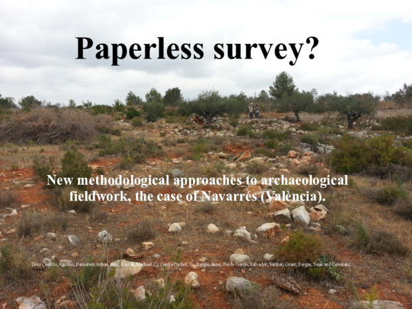
In the Symposium "Making Sense of Archaeological Survey we report on new digital field methods we have applied in La Canal de Navarrés (Valencia) in the summer of 2014. Although we have carried out archaeological surveys in the Valencian Region for 25 years, this was the first time we undertook archaeological survey, in a new research area, without the support of any kind of documents in hard copies (e.g., paper maps, forms, aerial photos, transparencies or any other kind). All supporting documentation was carried to the field in digital tablets (two iPad Minis and one Android) or smartphones (iPhone or Samsung Galaxy). On the iOS platform, after evaluating other alternatives (iris, Autocad 360, ArcGis, ...), we selected the CartoMobile© GIS app for recording survey data. On the Android platform, after evaluating other alternatives (OruxMaps©, gvSIG mini, OSM tracker©, ...) we chose the OsmAnd© app. The functionalities in both are similar but CartoMobile is what we might call a...
Trabajos de Prehistoria
Methodological proposal for a systematic archaeological survey: the case of the Guadiana Menor Valley (Jaén, Spain)2003 •
XVI REUNIÓN TÉCNICA DE CONSERVACIÓN-RESTAURACIÓN Documentar en la conservación-restauración. Métodos y nuevas tecnologías
Proposta metodològica per a l'estudi i la documentació dels paviments conservats a la Neàpolis i la ciutat romana d'Empúries2020 •
The systematic excavation of Empúries began in 1908, and since then a substantial number of mosaics have been exhumed. Nonetheless, information on most of these mosaics remains unpublished. With a view to bringing about a change of course, we have begun a study project that will provide an in-depth understanding of the floors. To perform the study, during the past few years we have focused on the systematic collection of descriptive, graphic and cartographic information from the pavements, with consideration for their formal characteristics. This has helped us define the basic requirements for the information system that will manage the large variety and quantity of documentation generated as part of this interdisciplinary study in a standardised manner. L’any 1908 s’iniciaren les excavacions sistemàtiques a Empúries i des de llavors s’ha exhumat un important conjunt de paviments. La major part de la informació que en tenim resta inèdita; per aquest motiu, amb voluntat d’iniciar un canvi de rumb, hem engegat un projecte d’estudi que en generarà un coneixement profund. Per dur-lo a terme, durant els darrers anys ens hem centrat en la recollida sistemàtica d’informació descriptiva, gràfica i cartogràfica dels paviments atenent a les seves característiques formals. Això ens ha permès definir els requeriments bàsics del sistema d’informació que gestionarà de manera normalitzada la gran varietat i quantitat de documentació produïda en un estudi de caràcter interdisciplinari com aquest.
Trabajos De Prehistoria
Methodological proposal for a systematic archaeological survey: the case of the Guadiana Menor Valley (Jaén, Spain2003 •
Temas y tendencias actuales de investigación. Actas de las II Jornadas Doctorales en Ciencias de la Antigüedad
Óscar Bonilla Santander (2017): "Por una arqueología materialista, social y del paisaje" en Aranda, et al. (Eds.) Temas y tendencias actuales de investigación. Actas de las II Jornadas Doctorales en Ciencias de la Antigüedad, Universidad de Zaragoza, pp. 37-48.2017 •
A la hora de comenzar un trabajo de investigación cuyo objetivo es la consecución del título de doctorado en el campo de las ciencias sociales planteamos como imprescindible abordar la cuestión del marco teórico en el que se desarrollará la investigación. En el presente trabajo exponemos algunos los problemas que pueden condicionar el resultado de la investigación si se elude esta fase en el proceso de producción científica y cómo la asunción de cualquiera de las diferentes corrientes dominantes en arqueología condiciona el resultado final de la investigación y las conclusiones acerca de las formaciones sociales del pasado.
Presentem els resultats de les excavacions portades a terme dins el recinte del conjunt arqueològic emporità durant els anys 2016 i 2017 per part del Museu d’Arqueologia de Catalunya-Empúries, conjuntament ambles dades més rellevants obtingudes en altres treballs de prospecció i sondeig realitzats a l’entorn més immediat.
En aquesta contribució presentem de manera conjunta els resultats de les excavacions portades a terme durant els anys 2014 i 2015 dins els límits del conjunt arqueològic d’Empúries, així com també les intervencions preventives realitzades al seu entorn que han estat coordinades des del Museu d’Arqueologia de Catalunya-Empúries.
Complutum 24 (1) 9-28
Field survey methodology in regional and artefactual scale. The Ager Segisamonensis Survey Project, Odra-Pisuerga region (Burgos) (Spanish language)"This paper presents the Ager Segisamonensis Survey Project, an archaeological survey which focus to the development of methodologies to cope with off-site artefact’s scatters in relationships with both pre-roman and roman settlements. A debate is proposed against transactional field-dependant surveys and therefore we propose a new analytical system based in an artificial orthogonal grid for both summarizing, interpret and display the complex artefact variability. In addition we present a reflection about the methodological shift from off-site survey and site discovery which need an adapted recording methodology. The proposed methodology integrates GIS and GPS tools in order to analyse the spatiality of datasets by calculations as Percent Volume Contour and Nearest Neighbour Analysis."
Magyar Pszichológiai Szemle
Egészségpszichológiai kutatások és az alkalmazott egészségpszichológiai ellátás fejlődése az elmúlt 30 évben Magyarországon2022 •
A tanulmány az egészségpszichológia elmúlt évtizedekben Magyarországon lezajlott szakmai fejlődését tekinti át. A programiaddá személyek felsorolása mellett részletesen tárgyalja a kutatási irányokat és az ellátási gyakorlat meghatározó eredményeit. Kiemelt figyelmet fordít a szakma specifikus fogalmainak bemutatására, a beavatkozások kompetenciaterületeire, valamint az egészségpszichológiai, a magatartás-orvoslás, a pszichoszomatika, a klinikai pszichológia területekkel való kapcsolatának értelmezésére. Bemutatja az új szakmai mentalitás és ellátási lehetőségek kialakulását, és ráirányítja a figyelmet az alkalmazott egészségpszichológiai ellátás és az egészségfejlesztés kiemelt fontosságú területeire, a társadalmi és mentális fejlődésben betöltött szerepükre. Továbbá szemelvényeket sorol fel a nemzetközi trendekhez való kapcsolódás kiemelkedő hazai eredményeiről. Az egészségügyi finanszírozást és ellátást tervező országos döntéshozók számára a testi, lelki és szociális egészség növ...
Ḥadashot Arkheologiyot— Excavations and Surveys in Israel 135
Ramla, Danny Mass Street: The Glass Vessels2023 •
Counterspeech: Multidisciplinary Perspectives on Countering Dangerous Speech
The Philosophy of Counter-Language (w. B. Cepollaro)2024 •
skripsi-client.googlecode.com
APLIKASI SMS GATEWAY UNTUK LAYANAN SISTEM INFORMASI BIMBINGAN BELAJAR PADA BIMBINGAN BELAJAR SMART EDUDeiksis : Jurnal Pendidikan Bahasa dan Sastra Indonesia
Mitos Danau Sebagai Pelestari Lingkungan2017 •
2013 •
2010 •
Social Cognitive and Affective Neuroscience
How representative are neuroimaging samples? Large-scale evidence for trait anxiety differences between fMRI and behaviour-only research participants2021 •
Australasian journal of ultrasound in medicine
The umbilical vein in the human fetus has a non‐linear growth pattern across gestation2016 •
 Joan Bernabeu-Auban