Envigado
Appearance
Envigado | |
|---|---|
| Nickname(s): City of ceibas and doves | |
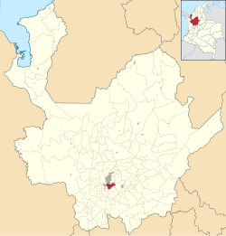
 Location of the city (urban in red) and municipality (dark gray) of Envigado in Antioquia Department. | |
| Coordinates: 6°09′N 75°36′W / 6.150°N 75.600°W | |
| Departamento | Antioquia |
| Region | Valle de Aburrá |
| Government | |
| • Mayor | José Diego Gallo Riaño |
| Area | |
| • Total | 50 km2 (20 sq mi) |
| Elevation | 1,575 m (5,167 ft) |
| Population (2005) | |
| • Total | 175,240[1] |
| • Density | 3,504.8/km2 (9,077/sq mi) |
| Time zone | UTC-5 |
| Website | Government of Envigado official website |
Envigado (pronounced IPA: [ˈeŋβ̞iɡað̞o]) is a Colombian municipality in the northwestern part of the country and part of the Metropolitan Area of Medellín of the Antioquia Department.

References
- ↑ DANE (ed.). "Perfil Envigado - Antioquia" (PDF) (in Spanish). Retrieved 2009-10-29.
Wikimedia Commons has media related to Envigado.

