

Portal:Michigan highways
The State Trunkline Highway System of the US state of Michigan is a network of roads owned and maintained by the Michigan Department of Transportation (MDOT). The most prominent of these roads are part of one of three numbered highway systems in Michigan: Interstates Highways, US Highways, and the other State Trunklines. Other systems of roads are operated by the 83 counties in the state as well as each city.


Interstate Highways and US Highways are assigned at the national level. Interstate Highways are numbered in a grid—even-numbered highways are east–west highways (with the lowest numbers along Mexico and the Gulf of Mexico), and odd-numbered highways are north–south highways (with the lowest numbers along the Pacific Ocean). US Highways are also numbered in a grid—even numbered for east–west highways (with the lowest numbers along Canada) and odd numbered for north–south highways (with the lowest numbers along the Atlantic Ocean). For this reason, mainline (two-digit) Interstate Highways in Michigan all have numbers above 69 and mainline US Highways all have numbers below 45. Three-digit Interstate and U.S. Highways, also known as "child routes," are branches off their main one- or two-digit "parents". The Interstate and US Highways are maintained by MDOT. Interstate 75 (I-75) and US Highway 23 (US 23) are the longest examples in the state.


State Trunklines are the other state highways maintained by MDOT. These highways are completely owned and maintained by the state. Michigan highways are properly referred to using the M and never as "Route 28" or "Highway 115", but as M-28 or M-115. The marker used for state trunklines is a diamond with a block-letter "M" at the top. Roads that are maintained by the state but not assigned a state trunkline designation carry an unsigned highway designation.


County-Designated Highways are assigned numbers in a zone system by MDOT, but maintained by the counties. Each zone is indicated by a letter A–H which is followed by a number based on a grid inside that zone. Each county also maintains any other roadway that is not a state trunkline or a city street. The numbering and signing practices vary from county to county, as does the size of each county's system. Numerical designations typically do not carry over from one county to the next; a CDH that crosses county lines keeps its designation in each county however. County road designations are typically abbreviated "CR" or "Co Rd" followed by the number, and CDHs are abbreviated to just their letter and number assignment.
US Highway 27 (US 27) is a part of the US Highway System that now runs from Miami, Florida, to Fort Wayne, Indiana. In the US state of Michigan, it was a north–south state trunkline highway that entered the state south of Kinderhook and ended south of Grayling. Its route consisted of a freeway concurrency with Interstate 69 (I-69) from the state line north to the Lansing area before it followed its own freeway facility northward to St. Johns. From there north to Ithaca, US 27 was an expressway before continuing as a freeway to a terminus south of Grayling.
Created with the rest of the US Highway System on November 11, 1926, US 27 replaced a pair of state highways between the state line and the Cheboygan area. For a time, US 27 even extended from Cheboygan to St. Ignace over the Mackinac Bridge. The highway was converted into a series of freeways starting in the late 1950s. The northernmost section between Grayling and Mackinaw City, bypassing Cheboygan, became part of I-75, and US 27 was truncated to Grayling. Starting in the 1960s, the southern sections were included in I-69. The last section of Interstate in Michigan was completed in 1992 when I-69/US 27 opened southwest of Lansing. In the 1990s, a bypass of St. Johns north of Lansing was built, the last freeway segment of US 27 to open under that designation. On April 16, 1999, the American Association of State Highway and Transportation Officials (AASHTO) approved the removal of the US 27 designation from the state of Michigan; this change was put into place when the highway number was removed from signage in 2002. Former segments of US 27 from its pre-freeway configuration are still state highways in the form of M-27 between Indian River and Cheboygan or the various business routes in the state that previously bore Business US 27 (Bus. US 27) designations. (Full article...)
-
 Construction along I-96 for the interchange with M-231 in July 2013 (from Michigan State Trunkline Highway System)
 -
 Interstate HighwaysOther freewaysMiscellaneous expressways
 -
 Planning map for the Detroit area freeways from 1955
 -
 H-58 west of Grand Marais
 -
 Junction between M-28 and M-178 south of Munising before 1941
 -
 M-39 bridge over the River Rouge in Dearborn
 -
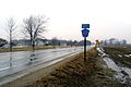
 Welcome sign along US 8
 -
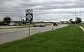
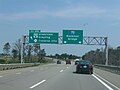 Exit 254 on I-75 south of Grayling
 -
 M-87 on November 1, 1956
 -
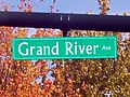 Grand River Avenue, once a part of M-16 and later US 16, was originally an Indian trail converted as a plank road before becoming a state highway.
 -
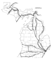
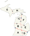 Map of the zone system
 -
 M-121 in Jenison
 -
 H-13 during winter
 -
 M-553 approaching Glass' Curve south of Marquette
 -
 A-2 in Allegan County south of Holland
 -
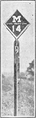 Milemarker used in 1922 for M-14
 -
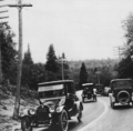 Dead Man's Curve along the Marquette–Negaunee Road shown in 1917 with its hand-painted centerline, the first in the nation
 -
 Map of the pre-statehood Indian trails


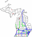
State Trunkline System, overview of the system
- Interstates Highways in the state
- US Highways in the state
- State Trunklines
- County-Designated Highways in the state
- Pure Michigan Byways, a system of scenic, historical or recreational highways in the state
- Great Lakes Circle Tour
Nominations and votes for selected articles and selected pictures are always needed. Anyone can nominate an article, and anyone can vote for an article. You can also recommend items for Did you know?. Improvements to the articles are always welcome as the project works on expanding and nominating the remaining ones for Good Article or Featured Article status.


