Kiryat Ono
Kiryat Ono
קִרְיַת אוֹנוֹ | |
|---|---|
City (from 1992) | |
| Hebrew transcription(s) | |
| • ISO 259 | Qiryat ʔono |
| • Also spelled | Qiryat Ono (official) |
| Coordinates: 32°03′49″N 34°51′19″E / 32.06361°N 34.85528°E | |
| Country | |
| District | |
| Founded | 1939 |
| Government | |
| • Mayor | Michal Rozenshine |
| Area | |
• Total | 4,112 dunams (4.112 km2 or 1.588 sq mi) |
| Population (2023)[1] | |
• Total | 43,241 |
| • Density | 11,000/km2 (27,000/sq mi) |
| Ethnicity | |
| • Jews and others | 99.8% |
| • Arabs | 0.2% |
| Website | www |
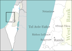
Kiryat Ono (Hebrew: קִרְיַת אוֹנוֹ) is a city in the Tel Aviv District of Israel. It is located 11 kilometres (6.8 mi) east of Tel Aviv. In 2022 it had a population of 43,241.[1]
Modern Kiryat Ono is adjacent to the biblical Ono, which was located in what is now the area of Or Yehuda.[2] The city also took its name from the Palestinian village of Kafr 'Ana, which took its name from Ono, a biblical town of Benjamin.
History
[edit]
During the 18th and 19th centuries, the area of Kiryat Ono belonged to the Nahiyeh (sub-district) of Lod that encompassed the area of the present-day city of Modi'in-Maccabim-Re'ut in the south to the present-day city of El'ad in the north, and from the foothills in the east, through the Lod Valley to the outskirts of Jaffa in the west. This area was home to thousands of inhabitants in about 20 villages, who had at their disposal tens of thousands of hectares of prime agricultural land.[3]
A settlement named Kfar Ono was established in 1939. During the 1950s, a ma'abara (transit camp for new immigrants in Israel) was established nearby. In 1954, the settlement merged with other communities to form Kiryat Ono. It achieved city status in 1992.[4]
In a park, a lone sycamore tree stands on a hill overlooking the Tel HaShomer base; this tree has been adopted as the city's spiritual and cultural icon. The lands surrounding the tree were owned as agricultural land and maintained by Aryeh Konikov. When the lone tree was planted, it seemed unique in its location, and Mr. Konikov nourished it and maintained the land surrounding it for many years. That land has now become a part of a park named Ricefield.
Demographics
[edit]
According to the Israel Central Bureau of Statistics (CBS), in 2001 the ethnic makeup of the city was Jewish and other non-Arabs. Kiryat Ono has grown significantly in recent years. According to CBS, in 2014 there were 17,700 males and 18,900 females. The population of the city was spread out, with 32.4% 19 years of age or younger, 9.8% between 20 and 29, 24.3% between 30 and 44, 14.9% from 45 to 59, 5.0% from 60 to 64, and 13.6% 65 years of age or older. The population growth rate in 2014 was 3.0%.
According to CBS, as of 2013, in the city, there were 16,400 salaried workers and 1,417 self-employed residents. The mean monthly wage in 2013 for a salaried worker in the city was ILS 12,543, a real change of 0.6% over the course of 2012. Salaried males had a mean monthly wage of ILS 15,487 (a real change of 1.0%) versus ILS 9,877 for females (a real change of 0.9%). The mean income for self-employed residents was 12,598. There were 282 people who received unemployment benefits and 162 people who received an income guarantee.
Education
[edit]There are 11 schools in the city: 7 state elementary schools (Alumim, Rimonim, Warsaw, Nir, Jacob Cohen, and Sharett), 1 religious state elementary school, 1 Democratic school, 3 middle schools (Shazar, Ben Zvi and Peres Junior High), and 1 high school (Ben Zvi High school). 6,465 pupils study at the schools. The city also hosts Ono Academic College, an accredited private college with 8,500 students.[5]
International relations
[edit]Twin towns
[edit]Kiryat Ono is twinned with:
 Ioannina, Greece
 Smallingerland, Netherlands[6]
 Drachten, Netherlands
 Dormagen, Germany
 Offenbach (district), Germany
In the year 2009, the twin cities alliance with Drachten suffered from a diplomatic crisis, as the mayor of Drachten was unwilling to visit Kiryat Ono for political reasons. A comedic late night show in GLZ Radio (the IDF radio station) held a campaign to preserve the twin cities agreement.[7] Eventually, the crisis was resolved.
Notable people
[edit]- Abigail and Marc-Daniel Aroyo, children murdered in a 1971 terrorist attack
- Gilad Erdan (born 1970), politician
- Eyal Ran (born 1972), tennis player
- Lavih Serfaty (born 1945), artist and author[8][9]
- Shez (born 1959), poet, writer, playwright, singer, and songwriter
- Yona Wallach (1944–1985), poet
References
[edit]- ^ a b c "Regional Statistics". Israel Central Bureau of Statistics. Retrieved 21 March 2024.
- ^ Walid Khalidi, All that Remains, Washington, D.C. 1992, pp. 247-248; Carta's Official Guide to Israel, Jerusalem 1983, p. 358.
- ^ Marom, Roy (2022). "Lydda Sub-District: Lydda and its countryside during the Ottoman period". Diospolis - City of God: Journal of the History, Archaeology and Heritage of Lod. 8: 103–136.
- ^ "Qiryat Ono (Israel)". Crwflags.com. Retrieved 2013-03-26.
- ^ "Ono Academic College - PROFILE - ONO ACADEMIC COLLEGE". Ono.ac.il. Retrieved 2013-03-26.
- ^ "Smallingerland steekt geen energie meer in zusterstad Kiryat Ono | Drachtster Courant".
- ^ "mynet קמפיין: מצילים את הברית עם דראכטן - מרכז". 2009-08-28. Archived from the original on 2009-08-28. Retrieved 2024-03-04.
- ^ "Jewish Art - Lavih Serfaty".
- ^ "Lavih serfaty".
External links
[edit]- Official website (in Hebrew)


