Hainan District
Appearance
Hainan
海南区 • ᠬᠠᠶᠢᠨᠠᠨ ᠲᠣᠭᠣᠷᠢᠭ | |
|---|---|
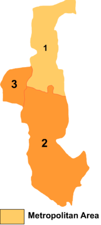
 Hainan District is labeled '2' on this map of Wuhai City | |
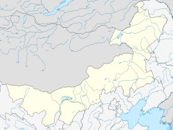
| Coordinates: 39°26′29″N 106°53′29″E / 39.44139°N 106.89139°E | |
| Country | China |
| Autonomous region | Inner Mongolia |
| Prefecture-level city | Wuhai |
| District seat | Lasengzhong Subdistrict |
| Area | |
• Total | 951.9 km2 (367.5 sq mi) |
| Elevation | 1,218 m (3,996 ft) |
| Population (2020)[1] | |
• Total | 94,770 |
| • Density | 100/km2 (260/sq mi) |
| Time zone | UTC+8 (China Standard) |
| Website | www |
| Hainan District | |||||||
|---|---|---|---|---|---|---|---|
| Chinese name | |||||||
| Simplified Chinese | 海南区 | ||||||
| Traditional Chinese | 海南區 | ||||||
| |||||||
| Mongolian name | |||||||
| Mongolian Cyrillic | Хайнан тойрог | ||||||
| Mongolian script | ᠬᠠᠶᠢᠨᠠᠨ ᠲᠣᠭᠣᠷᠢᠭ | ||||||
| |||||||
Hainan District (Mongolian: ᠬᠠᠶᠢᠨᠠᠨ ᠲᠣᠭᠣᠷᠢᠭ; Chinese: 海南区) is one of three districts of the city of Wuhai, Inner Mongolia, China, bordering Ningxia to the southwest.
Administrative divisions
[edit]Hainan District is made up of 2 subdistricts and 3 towns.
| Name | Simplified Chinese | Hanyu Pinyin | Mongolian (Hudum Script) | Mongolian (Cyrillic) | Administrative division code |
|---|---|---|---|---|---|
| Subdistricts | |||||
| Lasengzhong Subdistrict | 拉僧仲街道 | Lāsēngzhòng Jiēdào | ᠷᠠᠰᠢᠵᠦ᠋ᠩ ᠵᠡᠭᠡᠯᠢ ᠭᠤᠳᠤᠮᠵᠢ | Рашзон зээл гудамж | 150303001 |
| West Zhuozi Mountain Subdistrict | 西卓子山街道 | Xīzhuózishān Jiēdào | ᠪᠠᠷᠠᠭᠤᠨ ᠵᠦᠸᠧᠽᠢ ᠱᠠᠨ ᠵᠡᠭᠡᠯᠢ ᠭᠤᠳᠤᠮᠵᠢ | Баруун зүвези шин зээл гудамж | 150303001 |
| Towns | |||||
| Gun Us Town | 公乌素镇 | Gōngwūsù Zhèn | ᠭᠦᠨᠤᠰᠤ ᠪᠠᠯᠭᠠᠰᠤ | гүн ус балгас | 150303102 |
| Lasengmiao Town | 拉僧庙镇 | Lāsēngmiào Zhèn | ᠷᠠᠰᠢᠵᠦ᠋ᠩ ᠰᠦᠮᠡ ᠪᠠᠯᠭᠠᠰᠤ | Рашзон сүм балгас | 150303103 |
| Bayan Tohoi Town | 巴音陶亥镇 | Bāyīntáohài Zhèn | ᠪᠠᠶᠠᠨᠲᠣᠬᠣᠢ ᠪᠠᠯᠭᠠᠰᠤ | Баяндахуй балгас | 150303104 |
References
[edit]- www.xzqh.org (in Chinese)

