Bungo Channel
Appearance
(Redirected from Bungo Strait)
| Bungo Channel | |
|---|---|
| 豊後水道 (Japanese) | |
 Bungo Channel Map | |
| Location | Japan |
| Coordinates | 32°54′32″N 132°15′00″E / 32.909°N 132.25°E |
| Type | strait |
| Basin countries | Japan |
| Settlements | Ōita, Uwajima, Seiyo, Sukumo |
| References | Bungo Strait: Japan National Geospatial-Intelligence Agency, Bethesda, MD, USA |
| Location | |
 | |
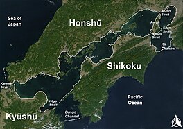
The Bungo Channel (豊後水道, Bungo-suidō[1]) is a strait separating the Japanese islands of Kyushu and Shikoku. It connects the Philippine Sea and the Seto Inland Sea on the western end of Shikoku.[2] The narrowest part of this channel is the Hōyo Strait.
In the English-speaking world, the Bungo Strait is most known as a setting in the 1958 World War II submarine film Run Silent, Run Deep, based upon the best-selling 1955 novel by then-Commander Edward L. Beach Jr.[3] On 9 November 1944, the USS Archerfish sank the Shinano, just nine hours into its maiden voyage in the Bungo strait. Shinano had been built in secret after being converted to a carrier, from a battleship of the Yamato class.
Notes
[edit]- ^ Teikoku's Complete Atlas of Japan, Teikoku-Shoin Co., Ltd., Tokyo, ISBN 4-8071-0004-1
- ^ Nussbaum, Louis-Frédéric. (2005). "Bungo Kaikyō" in Japan Encyclopedia, p. 91.
- ^ Sheffield, Richard. (2009). Subs on the Hunt: 40 of the Greatest WWII Submarine War Patrols, p. 24, at Google Books; Leeman, Sergio and Robert Wise. (1995). Robert Wise on his Films: from Editing Room to Director's Chair, p. 145.
References
[edit]- Leeman, Sergio and Robert Wise. (1995). Robert Wise on his Films: from Editing Room to Director's Chair. Los Angeles: Silman-James. ISBN 9781879505247; OCLC 243829638
- Nussbaum, Louis-Frédéric and Käthe Roth. (2005). Japan encyclopedia. Cambridge: Harvard University Press. ISBN 978-0-674-01753-5; OCLC 58053128
- Sheffield, Richard. (2009). Subs on the Hunt: 40 of the Greatest WWII Submarine War Patrols. Atlanta: Fox Publishing. ISBN 9781442169388; OCLC 652102659
