Orior Lower: Difference between revisions
Appearance
Content deleted Content added
m Reverted edits by 81.157.233.118 (talk) to last version by JamesBWatson |
m added Clare Tags: Visual edit Mobile edit Mobile web edit |
||
| (10 intermediate revisions by 10 users not shown) | |||
| Line 1: | Line 1: | ||
| ⚫ | |||
{{Use British English|date=October 2013}} |
{{Use British English|date=October 2013}} |
||
| ⚫ | |||
{{Infobox settlement |
{{Infobox settlement |
||
<!-- See Template:Infobox settlement for additional fields and descriptions --> |
<!-- See Template:Infobox settlement for additional fields and descriptions --> |
||
| Line 33: | Line 33: | ||
| elevation_ft = |
| elevation_ft = |
||
}} |
}} |
||
'''Orior Lower''' (from {{lang-ga|[[Ind Airthir|Airthir]]}}, the name of an ancient [[Gaelic Ireland|Gaelic]] territory)<ref name="Roots"/><ref name="Generations"/> is a [[Barony ( |
'''Orior Lower''' (from {{lang-ga|[[Ind Airthir|Airthir]]}}, the name of an ancient [[Gaelic Ireland|Gaelic]] territory)<ref name="Roots"/><ref name="Generations"/> is a [[Barony (Ireland)|barony]] in [[County Armagh]], [[Northern Ireland]].<ref name="PRONI"/> It lies in the east of the county and borders [[County Down]] with its eastern boundary. It is bordered by seven other baronies: [[Fews Upper]] to the south-west; [[Fews Lower]] to the west; [[Oneilland West]] to the north-west; [[Oneilland East]] to the north; [[Iveagh Lower, Lower Half]] to the north-east; [[Iveagh Upper, Upper Half]] to the east; and [[Orior Upper]] to the south. A small enclave of Orior Lower resides in the east of Orior Upper.<ref name="PRONI"/> |
||
==List of main settlements== |
==List of main settlements== |
||
| Line 44: | Line 45: | ||
===Villages and population centres=== |
===Villages and population centres=== |
||
*Eleven Lane Ends |
*Eleven Lane Ends |
||
*[[Clare, County Armagh|Clare]] |
|||
*[[Forkhill]] |
*[[Forkhill]] |
||
*[[Poyntzpass]] (split with [[Iveagh Upper, Upper Half]]) |
|||
*Jerrettspass |
*[[Jerrettspass]] |
||
*Laurelvale |
*Laurelvale |
||
*[[Loughgilly]] (also part in the baronies of Fews Lower and Orior Upper) |
*[[Loughgilly]] (also part in the baronies of Fews Lower and Orior Upper) |
||
| Line 61: | Line 64: | ||
refs= |
refs= |
||
<ref name="PRONI">[http://www.proni.gov.uk/index/local_history/geographical_index/baronies_.htm PRONI Baronies of Northern Ireland]</ref> |
<ref name="PRONI">[http://www.proni.gov.uk/index/local_history/geographical_index/baronies_.htm PRONI Baronies of Northern Ireland]</ref> |
||
<ref name="PRONI Parishes"> |
<ref name="PRONI Parishes">{{Cite web |url=http://applications.proni.gov.uk/geogindx/arma.htm |title=PRONI Civil Parishes of County Armagh |access-date=28 September 2010 |archive-url=https://web.archive.org/web/20080516233329/http://applications.proni.gov.uk/geogindx/arma.htm |archive-date=16 May 2008 |url-status=dead }}</ref> |
||
<ref name="Generations"> |
<ref name="Generations">{{Cite web |url=http://generation13.net/Baronies/baroniespages/armagh.html |title=Baronies of Armagh |access-date=28 September 2010 |archive-url=https://web.archive.org/web/20120313051842/http://generation13.net/Baronies/baroniespages/armagh.html |archive-date=13 March 2012 |url-status=dead }}</ref> |
||
<ref name="Roots">[http://www.rootsweb.ancestry.com/~irlkik/ihm/baronies.htm Ireland's History in Maps - The Baronies of Ireland]</ref> |
<ref name="Roots">[http://www.rootsweb.ancestry.com/~irlkik/ihm/baronies.htm Ireland's History in Maps - The Baronies of Ireland]</ref> |
||
<ref name="PRONI Map"> |
<ref name="PRONI Map">{{Cite web |url=http://applications.proni.gov.uk/geogindx/maps/bararma.gif |title=Baronies and civil parishes of County Armagh |access-date=6 February 2011 |archive-url=https://web.archive.org/web/20100217120729/http://applications.proni.gov.uk/geogindx/maps/bararma.gif |archive-date=17 February 2010 |url-status=dead }}</ref> |
||
<ref name="Logainm">{{cite web |url=http://www.logainm.ie/295.aspx |title=Orior Lower |work=Placenames Database of Ireland |publisher=Department of Community, Rural and Gaeltacht Affairs | |
<ref name="Logainm">{{cite web |url=http://www.logainm.ie/295.aspx |title=Orior Lower |work=Placenames Database of Ireland |publisher=Department of Community, Rural and Gaeltacht Affairs |access-date=8 June 2011}}</ref> |
||
}} |
}} |
||
{{County Armagh}} |
{{County Armagh}} |
||
{{Armagh |
{{Coord missing|County Armagh}} |
||
{{coord missing|County Armagh}} |
|||
[[Category:Barony of Orior Lower| ]] |
[[Category:Barony of Orior Lower| ]] |
||
{{Armagh-geo-stub}} |
|||
Revision as of 22:39, 2 September 2024
Orior Lower
| |
|---|---|
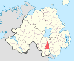
 Location of Orior Lower, County Armagh, Northern Ireland. | |
| Sovereign state | United Kingdom |
| Country | Northern Ireland |
| County | Armagh |
Orior Lower (from Template:Lang-ga, the name of an ancient Gaelic territory)[2][3] is a barony in County Armagh, Northern Ireland.[4] It lies in the east of the county and borders County Down with its eastern boundary. It is bordered by seven other baronies: Fews Upper to the south-west; Fews Lower to the west; Oneilland West to the north-west; Oneilland East to the north; Iveagh Lower, Lower Half to the north-east; Iveagh Upper, Upper Half to the east; and Orior Upper to the south. A small enclave of Orior Lower resides in the east of Orior Upper.[4]
List of main settlements
Below is a list of settlements within Orior Lower:[1]
Towns
Villages and population centres
- Eleven Lane Ends
- Clare
- Forkhill
- Poyntzpass (split with Iveagh Upper, Upper Half)
- Jerrettspass
- Laurelvale
- Loughgilly (also part in the baronies of Fews Lower and Orior Upper)
List of civil parishes
Below is a list of civil parishes in Orior Lower:[5][6]
- Ballymore
- Forkill
- Killevy (split with barony of Orior Upper)
- Kilmore (split with barony of Oneilland West, not be confused with separate civil parish of Kilmore in County Down)
- Loughgilly (split with baronies of Fews Upper and Orior Upper)
References
- ^ a b "Orior Lower". Placenames Database of Ireland. Department of Community, Rural and Gaeltacht Affairs. Retrieved 8 June 2011.
- ^ Ireland's History in Maps - The Baronies of Ireland
- ^ "Baronies of Armagh". Archived from the original on 13 March 2012. Retrieved 28 September 2010.
- ^ a b PRONI Baronies of Northern Ireland
- ^ "PRONI Civil Parishes of County Armagh". Archived from the original on 16 May 2008. Retrieved 28 September 2010.
- ^ "Baronies and civil parishes of County Armagh". Archived from the original on 17 February 2010. Retrieved 6 February 2011.
