Moatize: Difference between revisions
Mikeypitt7 (talk | contribs) |
Gaismagorm (talk | contribs) m oh thats what im supposed to do when i see that mistake. oopsies. |
||
| (26 intermediate revisions by 19 users not shown) | |||
| Line 1: | Line 1: | ||
{{Infobox settlement |
{{Infobox settlement |
||
|official_name |
| official_name = Moatize |
||
|other_name |
| other_name = |
||
|native_name |
| native_name = |
||
|nickname |
| nickname = |
||
|motto |
| motto = |
||
|image_skyline |
| image_skyline = File:Bacia Carbonífera de Moatize em Tete - panoramio - Nelson Deolinda Amin… (14).jpg |
||
|imagesize |
| imagesize = 250px |
||
|image_caption |
| image_caption = Landscape in Moatize |
||
|image_flag |
| image_flag = |
||
|flag_size |
| flag_size = |
||
|image_seal |
| image_seal = |
||
|seal_size |
| seal_size = |
||
|image_shield |
| image_shield = |
||
|shield_size |
| shield_size = |
||
|image_blank_emblem |
| image_blank_emblem = |
||
|blank_emblem_size |
| blank_emblem_size = |
||
|image_map |
| image_map = |
||
|mapsize |
| mapsize = |
||
|map_caption |
| map_caption = |
||
|pushpin_map |
| pushpin_map = Mozambique |
||
|pushpin_label_position = |
| pushpin_label_position = |
||
|pushpin_mapsize |
| pushpin_mapsize = 200 |
||
| ⚫ | |||
|coordinates_region = MZ |
|||
| ⚫ | |||
| ⚫ | |||
| ⚫ | |||
| ⚫ | |||
| ⚫ | |||
| ⚫ | |||
| ⚫ | |||
| ⚫ | |||
| ⚫ | |||
| ⚫ | |||
| government_type = |
|||
| ⚫ | |||
| |
| leader_title = |
||
| |
| leader_name = |
||
| ⚫ | |||
| ⚫ | |||
| ⚫ | |||
| ⚫ | |||
| ⚫ | |||
| ⚫ | |||
| ⚫ | |||
| ⚫ | |||
| ⚫ | |||
| ⚫ | |||
| ⚫ | |||
| ⚫ | |||
| ⚫ | |||
| ⚫ | |||
| established_date3 = |
|||
| ⚫ | |||
| |
| area_magnitude = |
||
| ⚫ | |||
| ⚫ | |||
| area_footnotes = |
|||
| ⚫ | |||
| |
| area_total_km2 = |
||
| |
| area_land_km2 = |
||
| |
| area_water_km2 = |
||
| ⚫ | |||
|area_water_km2 = |
|||
| ⚫ | |||
| ⚫ | |||
| ⚫ | |||
| ⚫ | |||
| area_water_percent = |
|||
| ⚫ | |||
| |
| area_urban_km2 = |
||
| area_urban_sq_mi = |
|||
|area_urban_km2 = |
|||
| |
| area_metro_km2 = |
||
| ⚫ | |||
|area_metro_km2 = |
|||
| ⚫ | |||
| ⚫ | |||
| ⚫ | |||
| ⚫ | |||
| ⚫ | |||
| ⚫ | |||
| ⚫ | |||
| ⚫ | |||
| ⚫ | |||
| ⚫ | |||
| ⚫ | |||
| ⚫ | |||
| ⚫ | |||
| ⚫ | |||
| ⚫ | |||
| ⚫ | |||
| ⚫ | |||
| ⚫ | |||
| ⚫ | |||
| ⚫ | |||
| ⚫ | |||
| ⚫ | |||
| ⚫ | |||
| ⚫ | |||
| ⚫ | |||
| ⚫ | |||
| ⚫ | |||
| ⚫ | |||
| |
| utc_offset = |
||
| |
| timezone_DST = |
||
| |
| utc_offset_DST = |
||
| coordinates = {{coord|16|07|S|33|44|E|region:MZ|display=inline}} |
|||
| ⚫ | |||
| ⚫ | |||
|latd= 16|latm= 07|lats= |latNS=S |
|||
| ⚫ | |||
|longd=33|longm=44|longs= |longEW=E |
|||
| elevation_ft = |
|||
| ⚫ | |||
| ⚫ | |||
| ⚫ | |||
| |
| postal_code = |
||
| ⚫ | |||
| ⚫ | |||
| blank_name = [[Köppen climate classification|Climate]] |
|||
|postal_code = |
|||
| ⚫ | |||
|area_code = |
|||
| |
| website = |
||
| ⚫ | |||
| ⚫ | |||
|website = |
|||
|footnotes = |
|||
}} |
}} |
||
'''Moatize''' is the |
'''Moatize''' is the principal town and administrative center of [[Moatize District]] in western [[Mozambique|Mozambique's]] [[Tete Province]]. It is located on the eastern side of the [[Zambezi River]] at the confluence of the Moatize and [[Revúboé River|Revuboe Rivers]]. After [[Tete, Mozambique|Tete]], it is the second largest urban area, by population, in western Mozambique. |
||
== Economy == |
== Economy == |
||
The economy of Moatize is based in the extraction of natural resources, specifically coking coal. The surrounding coal basin has an estimated 2.5 billion tons of coal. In 2006, [[Vale (mining company)|VALE]], a [[Brazil]]ian company gained a concession to build and operate a coal mine at Moatize to export coal via rail to [[Beira, Mozambique|Beira]], a Mozambican port. As of 2012, eight mining companies operated within the greater Moatize area, including [[Riversdale Mining]],<ref>[http://www.riversdalemining.com.au/ Riversdale Mining Limited<!-- Bot generated title -->]</ref> an Australian company. |
The economy of Moatize is based in the extraction of natural resources, specifically [[Metallurgical coal|coking coal]]. The surrounding coal basin has an estimated 2.5 billion tons of coal. In 2006, [[Vale (mining company)|VALE]], a [[Brazil]]ian company gained a concession to build and operate a coal mine at Moatize to export coal via rail to [[Beira, Mozambique|Beira]], a Mozambican port. As of 2012, eight mining companies operated within the greater Moatize area,<ref>Rosenfeld, D. 2012. The coal mining sector in Mozambique: A simple model for predicting government revenue. Maputo: Instituto de Estudos Sociais e Económicos.</ref> including [[Riversdale Mining]],<ref>[http://www.riversdalemining.com.au/ Riversdale Mining Limited<!-- Bot generated title -->] {{webarchive|url=https://web.archive.org/web/20080105045840/http://www.riversdalemining.com.au/ |date=2008-01-05 }}</ref> an Australian company. |
||
Additionally, there are several small-scale businesses located in and around Moatize that cater to international businessmen engaged in the coal mining industry, including several small hotels, restaurants, and night clubs. |
Additionally, there are several small-scale businesses located in and around Moatize that cater to international businessmen engaged in the coal mining industry, including several small hotels, restaurants, and night clubs. |
||
| Line 95: | Line 93: | ||
== Transport == |
== Transport == |
||
Mozambique's N7 Highway, the principle paved route heading east to Malawi, passes through town. Moatize is also the terminal stop on the rehabilitated [[Sena railway]] (Dona Ana-Moatize branch line) that links western Mozambique to the port city of [[Beira, Mozambique|Beira]].<ref name="Impacto">[https://documents1.worldbank.org/curated/pt/392121468774972372/pdf/E9620paper.pdf Beira Rail Concession Project: Environmental Audit and Management Plan]. Maputo: Impacto, Projectos e Estudos Ambientais. 2004. pg. 58-60.</ref> To fully operationalize the line, approximately 670 km of railway was upgraded at a cost of $375m.<ref>[[Australian Financial Review]], 24 November 2007, p16</ref> The first train in more than two decades reached Moatize on January 30, 2010.<ref>[http://www.railwaygazette.com//news/single-view/view//sena-line-trains-return-to-moatize.html Railway gazette article]</ref> A second line, the [[Nacala railway]], connecting the Moatize basin with a new coal harbour at Nacala-a-Velha started operating in 2015.<ref>[http://www.macauhub.com.mo/en/2015/07/20/mozambiques-port-of-nacala-mozambique-to-start-exporting-coal/ Mozambique’s port of Nacala, Mozambique to start exporting coal]</ref> Construction of a third rail line connecting the Moatize basin with the Indian Ocean coast at Macuse, Zambezia, is now scheduled to start in 2017, after struggling with financing difficulties.<ref>[https://furtherafrica.com/2016/07/13/construction-of-new-port-and-railway-in-mozambique-begins-in-2017/ Construction of new port and railway in Mozambique begins in 2017 ]</ref> |
|||
==Demographics== |
==Demographics== |
||
{| class="wikitable" |
{| class="wikitable" |
||
! Year |
! Year |
||
! Population<ref name=wg>{{cite web |url=http://world-gazetteer.com/wg.php?x=&men=gcis&lng=en&des=wg&srt=npan&col=abcdefghinoq&msz=1500&geo=-153 |title=Mozambique: largest cities and towns and statistics of their population |accessdate=2008-06-18 |work=World Gazetteer |date= }}</ref> |
! Population<ref name=wg>{{cite web |url=http://world-gazetteer.com/wg.php?x=&men=gcis&lng=en&des=wg&srt=npan&col=abcdefghinoq&msz=1500&geo=-153 |title=Mozambique: largest cities and towns and statistics of their population |accessdate=2008-06-18 |work=World Gazetteer |date= }}{{dead link|date=July 2021|bot=medic}}{{cbignore|bot=medic}}</ref> |
||
|- |
|- |
||
| 2007 |
| 2007 |
||
| 39 |
| 39,073 |
||
|} |
|} |
||
| Line 116: | Line 114: | ||
{{coord|16|07|S| 33|44|E|region:MZ_type:city|display=title}} |
{{coord|16|07|S| 33|44|E|region:MZ_type:city|display=title}} |
||
[[Category:Populated places in Mozambique]] |
|||
[[Category:Populated places in Tete Province]] |
[[Category:Populated places in Tete Province]] |
||
{{Mozambique-geo-stub}} |
{{Mozambique-geo-stub}} |
||
Latest revision as of 12:22, 20 February 2024
Moatize | |
|---|---|
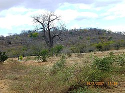
 Landscape in Moatize | |
| Coordinates: 16°07′S 33°44′E / 16.117°S 33.733°E | |
| Country | |
| Provinces | Tete Province |
| Population (2007) | |
| • Total | 39,073 |
| Climate | BSh |
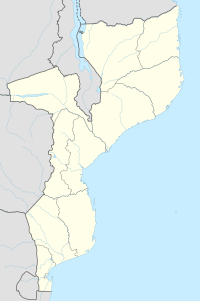
Moatize is the principal town and administrative center of Moatize District in western Mozambique's Tete Province. It is located on the eastern side of the Zambezi River at the confluence of the Moatize and Revuboe Rivers. After Tete, it is the second largest urban area, by population, in western Mozambique.
Economy
[edit]The economy of Moatize is based in the extraction of natural resources, specifically coking coal. The surrounding coal basin has an estimated 2.5 billion tons of coal. In 2006, VALE, a Brazilian company gained a concession to build and operate a coal mine at Moatize to export coal via rail to Beira, a Mozambican port. As of 2012, eight mining companies operated within the greater Moatize area,[1] including Riversdale Mining,[2] an Australian company.
Additionally, there are several small-scale businesses located in and around Moatize that cater to international businessmen engaged in the coal mining industry, including several small hotels, restaurants, and night clubs.
Transport
[edit]Mozambique's N7 Highway, the principle paved route heading east to Malawi, passes through town. Moatize is also the terminal stop on the rehabilitated Sena railway (Dona Ana-Moatize branch line) that links western Mozambique to the port city of Beira.[3] To fully operationalize the line, approximately 670 km of railway was upgraded at a cost of $375m.[4] The first train in more than two decades reached Moatize on January 30, 2010.[5] A second line, the Nacala railway, connecting the Moatize basin with a new coal harbour at Nacala-a-Velha started operating in 2015.[6] Construction of a third rail line connecting the Moatize basin with the Indian Ocean coast at Macuse, Zambezia, is now scheduled to start in 2017, after struggling with financing difficulties.[7]
Demographics
[edit]| Year | Population[8] |
|---|---|
| 2007 | 39,073 |
See also
[edit]References
[edit]- ^ Rosenfeld, D. 2012. The coal mining sector in Mozambique: A simple model for predicting government revenue. Maputo: Instituto de Estudos Sociais e Económicos.
- ^ Riversdale Mining Limited Archived 2008-01-05 at the Wayback Machine
- ^ Beira Rail Concession Project: Environmental Audit and Management Plan. Maputo: Impacto, Projectos e Estudos Ambientais. 2004. pg. 58-60.
- ^ Australian Financial Review, 24 November 2007, p16
- ^ Railway gazette article
- ^ Mozambique’s port of Nacala, Mozambique to start exporting coal
- ^ Construction of new port and railway in Mozambique begins in 2017
- ^ "Mozambique: largest cities and towns and statistics of their population". World Gazetteer. Retrieved 2008-06-18.[dead link]
16°07′S 33°44′E / 16.117°S 33.733°E
