Myagdi District (Nepali: म्याग्दी जिल्ला ), a part of Gandaki Province, is one of the seventy-seven districts of Nepal. The district, with Beni as its district headquarters, covers an area of 2,297 km2 (887 sq mi), had a population of 114,447 in 2001 and 113,641 in 2011. Magar people especially Pun Magar or simply Pun are the largest population in Maydi district.[1]
Myagdi District
(म्याग्दी जिल्ला)
| |
|---|---|
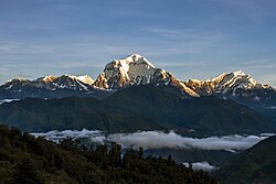
 View of Dhaulagiri from Ghorepani | |
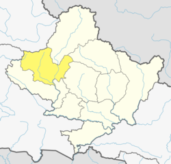
 Location of Myagdi (dark yellow) in Gandaki Province | |
| Country | |
| Province | Gandaki Province |
| Admin HQ. | Beni |
| Government | |
| • Type | Coordination committee |
| • Body | DCC, Myagdi |
| Area | |
| • Total | 2,297 km2 (887 sq mi) |
| Population (2021) | |
| • Total | 107,372 |
| • Density | 47/km2 (120/sq mi) |
| Time zone | UTC+05:45 (NPT) |
| Telephone Code | 069 |
| Main Language(s) | Nepali • Magar Kham |
In Myagdi district, there are many Pun villages, such as Doba (3rd largest Pun village), Narchyang, Paudwar, Pakhapani, Dana, Bega, Ghorepani, Chimkhola, Dagnam, Shikha, Baduk, Darmija, Kot Gau, Owlo, Rima / Bima, Histan gau, Dachale gau, Khibang, Kuye Pani gau, Muna gau, Dang, Ramche, Jaljala, Salija, Jhi/Jhin Patal khet, Begkhola, Mudi, Bhurung, Ulleri, BireThati, Tibilang, etc. Many Gorkha soldiers are recruited from here and have been serving in British Gorkha, many Pun from here have also served in Hong Kong as a British Gorkha soldier, Victoria Cross Tul Bahadur Pun (VC) and (CGC) Dipprasad Pun (British Gorkha Army) who received Conspicuous Gallantry Cross for an act of bravery, they are also from Myagdi.
The most popular tourist spots in Myagdi are: world famous Poon Hill / Pun Hill, Ghorepani, Pun Hill / Poon Hill Trek, Karbakeli Footpath, Beni Bazaar, Maharani Than, Dhaulagiri Himal, Todke, Jagannath Temple, Galeshwor Dham, Malika Dhuri, Singa Tatopani Kunda, Kaligandaki River, Rupse Jharna.
Myadi district is a mountains hills region and to reach this beautiful places, the neariest and easiest route is from Pokhara city to Beni as its district headquaters.
Geography and climate
editThis district can experience 7 types of climates
| Climate Zone[2]
i |
Elevation Range | % of Area |
|---|---|---|
| Upper Tropical | 300 to 1,000 meters 1,000 to 3,300 ft. |
0.1% |
| Subtropical | 1,000 to 2,000 meters 3,300 to 6,600 ft. |
17.5% |
| Temperate | 2,000 to 3,000 meters 6,400 to 9,800 ft. |
28.0% |
| Subalpine | 3,000 to 4,000 meters 9,800 to 13,100 ft. |
21.1% |
| Alpine | 4,000 to 5,000 meters 13,100 to 16,400 ft. |
17.8% |
| Nival | above 5,000 meters | 13.9% |
| Trans-Himalayan | 3,000 to 6,400 meters 9,800 to 21,000 ft. |
1.6% |
Demographics
editAt the time of the 2011 Nepal census, Myagdi District had a population of 113,641.
As their first language, 94.4% spoke Nepali, 2.2% Magar, 1.0% Magar Kham, 0.9% Chhantyal, 0.6% Newari, 0.1% Bhojpuri, 0.1% Gurung, 0.1% Hindi, 0.1% Maithili, 0.1% Sanskrit, 0.1% Sign language, 0.1% Thakali and 0.2% other languages.[4]
Ethnicity/caste: 39.6% were Magar, 17.0% Chhetri, 15.4% Kami, 8.0% Hill Brahmin, 5.8% Damai/Dholi, 3.5% Chhantyal, 3.4% Sarki, 2.0% Thakuri, 1.3% Newar, 1.0% Gurung, 0.9% Thakali, 0.5% Kisan, 0.2% Sanyasi/Dasnami, 0.2% Tamang, 0.1% Badi, 0.1% other Dalit, 0.1% Musalman, 0.1% Rai and 0.3% others.[5]
Religion: 87.2% were Hindu, 10.3% Buddhist, 1.3% Christian, 0.8% Prakriti, 0.2% Muslim and 0.2% others.[6]
Literacy: 71.5% could read and write, 2.3% could only read and 26.1% could neither read nor write.[7]
| Census year | Pop. | ±% p.a. | |
|---|---|---|---|
| 1981 | 96,904 | — | |
| 1991 | 100,552 | +0.37% | |
| 2001 | 114,447 | +1.30% | |
| 2011 | 113,641 | −0.07% | |
| 2021 | 107,372 | −0.57% | |
| |||
| Source: Citypopulation[8] | |||
Administration
editThe district consists of 6 Municipalities, out of which one is an urban municipality and five are rural municipalities. These are as follows:[9]
- Beni Municipality
- Annapurna Rural Municipality
- Dhaulagiri Rural Municipality
- Mangala Rural Municipality
- Malika Rural Municipality
- Raghuganga Rural Municipality
Former Village Development Committees
editPrior to the restructuring of the district, Myagdi District consisted of the following municipalities and Village development committees:
- Arman
- Arthunge
- Baadook
- Babiyachaur
- Baranja
- Begkhola
- Beni Municipality
- Bhakilmi
- Bhanbare
- Bima
- Chimkhola
- Dagnam
- Dana
- Darwang
- Devisthan
- Doba
- Ghar
- Ghatan
- Gurja Khani
- Histhan Mandali
- Jhin
- Jyamrukot
- Khibang
- Kuhunkot
- Kuinemangale
- Lulang
- Malkwang
- Marang
- Mudi
- Muna
- Nangi
- Narchyang
- Niskot
- Okharbot
- Pakhapani
- Patlekhet
- Pulachaur
- Rakhu Bhagawati
- Rakhupiple
- Ramche
- Ratnechaur
- Shikha
- Singa
- Takam
- Tatopani
- Ruma
Notable people
edit- Min Bahadur Sherchan, who was the oldest man to summit Mount Everest for about 5 years, was born in Myagdi district of Nepal was born here.[10]
- Nirmal Purja MBE, a mountaineer and former Gurkha and Special Boat Service (SBS) soldier.
- Mahabir Pun, Man who provided internet to remote villages and Leader Of National Innovation Center.
Infrastructures
edit- Tatopani Hydropower Station (2 MW)
See also
editReferences
edit- ^ "National Population and Housing Census 2011 (National Report)" (PDF). Central Bureau of Statistics. Archived from the original (PDF) on 2013-05-25. Retrieved June 1, 2015.
- ^ The Map of Potential Vegetation of Nepal - a forestry/agroecological/biodiversity classification system (PDF), Forest & Landscape Development and Environment Series 2-2005 and CFC-TIS Document Series No.110., 2005, ISBN 87-7903-210-9, retrieved November 22, 2013
- ^ 2011 Nepal Census, Social Characteristics Tables
- ^ NepalMap Language [1]
- ^ NepalMap Caste [2]
- ^ NepalMap Religion [3]
- ^ NepalMap Literacy [4]
- ^ "NEPAL: Administrative Division". www.citypopulation.de.
- ^ "स्थानिय तह" (in Nepali). Ministry of Federal Affairs and General Administration. Archived from the original on 31 August 2018. Retrieved 1 September 2018.
- ^ "Nepal's 86yo climber announces to attempt Everest again". The Himalayan Times. 2017-03-06. Retrieved 2018-07-12.
"Districts of Nepal". Statoids.