Ozamiz
Ozamiz | |
|---|---|
Ciudad | |
 | |
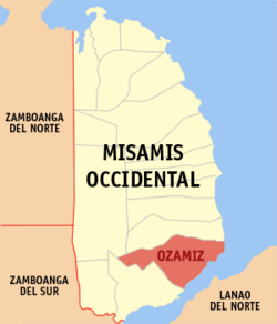
 Mapa de Misamis Occidental con Ozamiz resaltado | |
 | |
| Coordenadas: 8°9'N, 123°51'E | |
| Nación | Filipinas |
| Región | Mindanao del Norte (Región X) |
| Provincia | Misamis Occidental |
| Número de barangay | 51 |
| Fundación | 1757 |
| Gobierno | |
| • Type | ayuntamiento |
| • Electorado | Error en la secuencia de órdenes: la función «getValue» no existe. votantes (9 Mayo 2022) |
| Superficie | |
| • Total | 169,95 km2 (65,62 sq mi) |
| Elevation | 216 m (709 ft) |
| Populación (1 Mayo 2020) | |
| • Total | 140,334 |
| • Densidad | 0,83/km2 (2,1/sq mi) |
| • Hogares | 32,933 |
| Economía | |
| • Clase de ingresos | el tercera clase clase de ciudad |
| • Incidencia de la pobreza | Error en la secuencia de órdenes: la función «getValue» no existe.% (Error: fecha y hora no válidas.)[2] |
| • Ingresos | ₱ <strong4a4df3e5">Error (Error: fecha y hora no válidas.) |
| • Activos | ₱ <strong4a4df3e5">Error (Error: fecha y hora no válidas.) |
| • Pasivos | ₱ <strong4a4df3e5">Error (Error: fecha y hora no válidas.) |
| • Gastos | ₱ <strong4a4df3e5">Error (Error: fecha y hora no válidas.) |
| Huso horario | UTC+8 (PST) |
| Código postal | 7200 |
| PSGC | |
| Código telefonico | 88 |
| Lenguaje nativo | Subanon Cebuano Tagalog |
| Website | http://ozamizcity.com/ |
Ozamiz el tercera clase clase de ciudad na provincia de Misamis Occidental, Filipinas. Tiene este zona de 169.95 kilometro cuadrado.
Comporme del 1 Mayo 2020 censo este tiene papulidad de 140,334 personas y 32,933 hogares. El designada codigo postal 7200 y PSGC 104210000.
Barangay
revisa
|
|
|
Demografía
revisa| Año | Populación | ±% p.a. |
|---|---|---|
| 1903 | 11 709 | — |
| 1918 | 23 237 | +4.68% |
| 1939 | 36 313 | +2.15% |
| 1948 | 35 262 | −0.33% |
| 1960 | 44 091 | +1.88% |
| 1970 | 64 643 | +3.90% |
| 1975 | 71 559 | +2.06% |
| 1980 | 77 832 | +1.69% |
| 1990 | 91 503 | +1.63% |
| 1995 | 101 944 | +2.05% |
| 2000 | 110 420 | +1.73% |
| 2007 | 123 137 | +1.51% |
| 2010 | 131 527 | +2.43% |
| 2015 | 141 828 | +1.45% |
| 2020 | 140 334 | −0.21% |
| Ref: Autoridad de Estadísticas de Filipinas[3][4][5][6] | ||
Referencias
revisa- ↑ «Province: Misamis Occidental». PSGC Interactive. Quezon City, Philippines: Philippine Statistics Authority. Consultado el Diciembre 17, 2016.
- ↑ «PSA Releases the 2021 City and Municipal Level Poverty Estimates» (2 Abril 2024).
- ↑ Census of Population (2015). "Region X (Northern Mindanao)". Total Population by Province, City, Municipality and Barangay. Philippine Statistics Authority.
- ↑ Census of Population and Housing (2010). "Region X (Northern Mindanao)". Total Population by Province, City, Municipality and Barangay. NSO.
- ↑ Censuses of Population (1903–2007). "Region X (Northern Mindanao)". Table 1. Population Enumerated in Various Censuses by Province/Highly Urbanized City: 1903 to 2007. NSO.
- ↑ «Province of Misamis Occidental». Municipality Population Data. Local Water Utilities Administration Research Division. Consultado el Diciembre 17, 2016.
Enlaces externos
revisa- PhilAtlas.com
- Philippine Standard Geographic Code
- Local Governance Performance Management System
- ozamizcity
.com
| Provincia de Misamis Occidental | |
| Oroquieta (cabecera) | |
| Municipalidad: | Aloran ▪ Baliangao ▪ Bonifacio ▪ Calamba ▪ Clarin ▪ Concepcion ▪ Don Victoriano Chiongbian ▪ Jimenez ▪ Lopez Jaena ▪ Panaon ▪ Plaridel ▪ Sapang Dalaga ▪ Sinacaban ▪ Tudela |
| Ciudad: | Oroquieta ▪ Ozamiz ▪ Tangub |
