[go: up one dir, main page]

NC_Punt.jpg (400 × 400 píxels, mida del fitxer: 77 Ko, tipus MIME: image/jpeg)

Descripció a Commons

Resum

Descripció
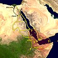
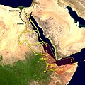
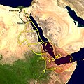
English: Map of the supposed location of Punt and trade routes from Egypt to Punt via rivers, wadis, and by sea. Mennefer is Memphis, Waset is Thebes, Irem and Nemyw are lands that supposedly border on Punt
Data 30 de novembre de 2009 (original upload date)
Font Transferred from en.wikipedia to Commons.
Autor Cush de la Viquipèdia en anglès

Llicència

Public domain S'ha alliberat aquesta obra al domini públic pel seu autor Cush de la Viquipèdia en anglès. Això s'aplica a tot el món.
En alguns països això pot no ser legalment possible, en tal cas:
Cush concedeix a tothom el dret d'usar aquesta obra per a qualsevol propòsit, sense cap condició llevat d'aquelles requerides per la llei.

This compound image uses free material land_shallow_topo_east.tif from NASA Visible Earth (formerly "Blue Marble") and world.200407.3x21600x21600.C1.png from JULY, BLUE MARBLE NEXT GENERATION

Registre original de càrregues

La pàgina de descripció original era aquí. Els noms d'usuari a continuació es refereixen a en.wikipedia.
  • 2009-11-30 00:57 Cush 400×400× (79081 bytes) Map of the supposed location of Punt
Any autoconfirmed user can overwrite this file from the same source. Please ensure that overwrites comply with the guideline.

Llegendes

Afegeix una explicació d'una línia del que representa aquest fitxer

Elements representats en aquest fitxer

representa l'entitat

amb drets d'autor, dedicat al domini p\u00fablic pel propietari dels drets d'autor<\/a>"}},"text\/plain":{"ca":{"P6216":"amb drets d'autor, dedicat al domini p\u00fablic pel propietari dels drets d'autor"}}}}" class="wbmi-entityview-statementsGroup wbmi-entityview-statementsGroup-P6216 oo-ui-layout oo-ui-panelLayout oo-ui-panelLayout-framed">
alliberat al domini p\u00fablic pel titular dels drets d'autor<\/a>"}},"text\/plain":{"ca":{"P275":"alliberat al domini p\u00fablic pel titular dels drets d'autor"}}}}" class="wbmi-entityview-statementsGroup wbmi-entityview-statementsGroup-P275 oo-ui-layout oo-ui-panelLayout oo-ui-panelLayout-framed">

Historial del fitxer

Cliqueu una data/hora per veure el fitxer tal com era aleshores.

Data/horaMiniaturaDimensionsUsuari/aComentari
actual04:33, 22 oct 2023Miniatura per a la versió del 04:33, 22 oct 2023400 × 400 (77 Ko)CushReverted to version as of 13:38, 28 February 2011 (UTC) Punt is considered to be on either side of the Bab-el-Mandeb
16:37, 29 set 2023Miniatura per a la versió del 16:37, 29 set 2023400 × 400 (68 Ko)BidiieyahanekoDue weight, majority of scholarly sources place Punt in Africa
14:38, 28 feb 2011Miniatura per a la versió del 14:38, 28 feb 2011400 × 400 (77 Ko)Freetrashbox{{Information |Description={{en|Map of the supposed location of Punt}} |Source=Transferred from [http://en.wikipedia.org en.wikipedia] |Date={{Date|2009|11|30}} (original upload date) |Author=Original uploader was Cush at [http://en.wiki

La pàgina següent utilitza aquest fitxer:

Ús global del fitxer

Utilització d'aquest fitxer en altres wikis: