[Getting there][Links][RoadTrip Facts] A scenic drive to Death Valley National Park is amazing any time of the year, but weather conditions are often ideal for a road trip in the winter and spring, when the valley temperatures at the Furnace Creek Visitor Center range from the middle 60s to the low 80s. Summertime temperatures can easily exceed 115 degrees and require more careful planning to fully enjoy the wonders that this park offers. Although several days would be required to see all parts of the park, we decided to undertake a one-day road trip starting in Las Vegas. Leaving the Las Vegas Strip, we drove south on Interstate 15 to Blue Diamond Road and turned west to begin our approach over the Spring Mountains. This section of the drive is known to locals as "crossing the hump to Pahrump." As we drove past the town of Blue Diamond, the eye-catching color of Red Rock Canyon was visible in the distance on the right side of the highway. We looked for some of the wild burros and horses that we have seen on past trips to this area. Despite the recent drought, we saw spring wildflowers beginning to appear as we reached the top of the pass and descended into the Pahrump Valley. The self-styled "oldest" (which is amusing, since it is also the only) winery in Nevada is located in the town of Pahrump. (Update August 2023: While the one visited is not currently operating, other wineries have since opened in the Pahrump area.) After a short tour and a taste of the winery's red, white, and sherry, we followed the locals' route to the national park. The road signs don't mention Death Valley, even though this is most direct route. Off to the northwest, we could see Ash Meadows National Wildlife Refuge. The spring-fed riparian environment is home to the second largest endemic population of animals, fish and plants in North America. The reserve is also home to 24 species of plants and animals that are only found here. On past trips, we have seen some of the very rare Devil's Hole Pupfish. Death Valley Junction was the next point of interest. A company town originally built in 1923 by the Pacific Coast Borax Company, the crossroads of California highways 127 and 190 doesn't rate a post office any more, but it has something far more entertaining. Marta Becket and Thomas Willett have been delighting locals and tourists at the "world famous" Amargosa Opera House since 1968 with their unique blend of dance and humor. They perform most evenings during the cooler months. Turning west from Death Valley Junction, we entered one of our favorite national parks, Death Valley. CA-190 follows the bottom of Furnace Creek Wash past the fantastic colors and geologic hues of the Funeral Mountains off to the right. To get an overview of the valley, we drove up to the mile-high vantage point of Dante's View. From the parking area at 5,475 feet we could look almost straight down to Badwater, which, at 248 feet below sea level, is the lowest point in the western hemisphere.
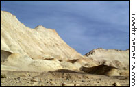
Retracing our path back down to the highway, we passed Hole in the Wall Canyon and turned left onto the one-way dirt road through Twenty Mule Team Canyon. In several places, it's possible to see the tiny mine openings the Borax miners used to crawl into the vertical cliffs while mining the desirable white mineral. The starkness of the landscape and the amazing range of colors in the soil are breathtaking, but we marveled most at the hardiness of the early miners who worked in such unforgiving surroundings.
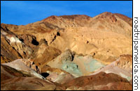
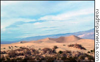
Returning to the highway, we stopped to enjoy the stunning views from Zabriskie Point before heading north to view Death Valley's sand dunes. The dunes, which are worth exploring on foot if you have the time, are not far from Stovepipe Wells, one of the few sources of water for early travelers to the valley. Our next stop was the incomparable Artists Palette road just south of Mushroom Rock on the way to Badwater. This nine-mile one-way paved track through the foothills of the Black Mountains is a favorite of photographers, especially in the raking light of sunrise and sunset. The intense purples, greens, reds, and browns are especially vivid in the late afternoon sun. Another favorite stop along the road to Badwater is the Devil's Golf course. From the highway, the area looks like a flat, brownish, white dirt patch, but up close the brown patches are jagged spikes of crystalline salt, some nearly two feet tall. Continuing on south, we slowed at Badwater, but we couldn't stop because the parking area is currently undergoing reconstruction. Because of its extraordinary negative altitude, it's one of the most visited destinations in the park. By now the sun had set, and we proceeded south past the ruins of a gold ore processing operation known as Ashford Mill, east to the town of Shoshone, and back to Las Vegas. With 3.3 million acres within its boundaries, Death Valley is huge, full of remarkable vistas, ghost towns, stunning mountain scenery and extraordinary desert secrets like the mysterious sliding stones of the Racetrack Playa. A road trip here is always an adventure! —Mark Sedenquist View
Death Valley, California Scenic Drive from the Las Vegas Strip, Nevada in a larger map
|